The latest news stories of interest in the Rogue Valley and around the state of Oregon from the digital home of Southern Oregon, Wynne Broadcasting’s RogueValleyMagazine.com
Monday, September 5, 2022

Rogue Valley Weather

Labor Day Forecast Hot and Dry — Please be Careful and Safe! Preventing wildfires is a responsibility we all share!
| With hot, dry conditions in the forecast & increased crowds for Labor Day weekend. Don’t be that spark that could lead to a tragedy! Check Conditions |
September May Be Warmer And Drier Than Normal – The climate outlook from NOAA’s Climate Prediction Center favors a warmer-than-average month for most of the United States, including Oregon and Washington.

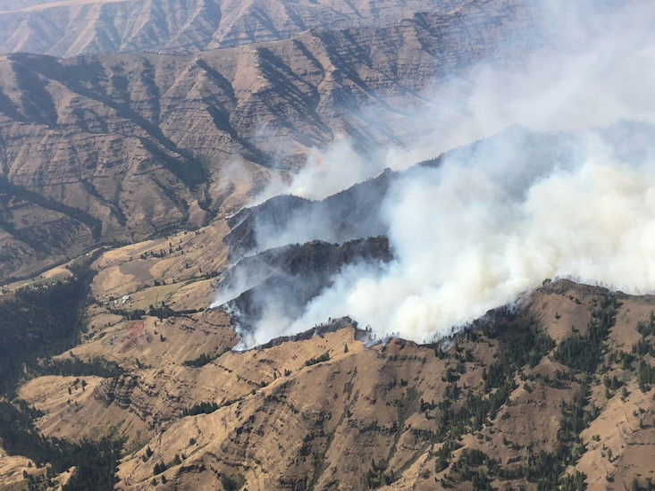
Rum Creek Fire Update
Containment on the deadly northern Josephine County wildfire is advancing as firefighters get slightly cooler, more humid weather to make progress containing it.

The Oregon National Guard is helping fight the Rum Creek Fire that has burned nearly 20,000 acres and is said to be 27% contained. Fifty-one guard members have been helping with the safety and security of the area with road closure points since Monday, Aug. 29, in the Merlin area.
Additionally, the guard has dispatched an HH-60 medical lift helicopter and crew to the Medford Airport to help if any firefighters or support staff become critically injured and need rapid transport for medical treatment.
Containment has risen to 27%, reaching that level yesterday in about a two-day span, up from 1% reported Thursday. The Unified Command (UC) says “containment” is an expression of confidence that a wildfire’s control lines will work given expected fire behavior and weather.
UC says today, “Nearly the entire Rum Creek Fire is encircled by well-defined control lines. Natural fire spread or tactical firing operations have burned the fuels adjacent to these lines. Crews are mopping up burned areas near the fire’s edges, searching for any hidden pockets of heat that might flare up later and allow the fire to escape fire lines. All of these remaining hot spots must be extinguished to secure the fire edge.”
It says parts of the fire’s containment line will not be declared “contained” until fire managers agree that segments of fire perimeter have cooled thoroughly and will not breach the line. UC says, “An increase in containment represents a lot of work: planning and preparing fire lines, deploying hose lays, tactical firings, monitoring for spot fires outside the lines, mopping up, and repeated checks with more mop up as needed.”
UC says yesterday fire personnel used tactical firing on the northwest side of the fire until firing operations were suspended when smoke was too thick for ignited fuels to burn well. It says crews plan to complete firing operations today, connecting the line from Mount Peavine north to the Rogue River.
UC says tactical firing also will eliminate fuels at the northeast side of the fire where the fire is slowly progressing through the McKnabe Creek drainage, and to the north and south, crews are mopping up areas near Grave Creek and Stratton Creek.
Evacuations: Existing evacuation orders and notifications remain in place. An interactive map showing evacuation levels according to address can be found at //JosephineCounty.gov/FireMap. For the most current evacuation information and resources, go to Josephine County Incident Information (rvem.org).
Road control: Josephine County Sheriff’s Office has established traffic access points around the fire zone. Road blocks are located at Galice Road near Crow Road; Galice Store; Bear Camp Road at Peavine (top intersection); Lower Grave Creek Road at Angora Creek (Grays Ranch); Quartz Creek Road about 3 miles up (end of County maintenance); Dutch Henry Road near Kelsey Creek (42 44’56.2/123 40’35.4); and Hog Creek at Galice Road. The National Guard is staffing the roadblocks. Only residents (must show proof of residency) and permitted users will be allowed through. https://inciweb.nwcg.gov/incident/article/8348/
Two people have been killed in the Mill Fire, burning in Weed
The Siskiyou County Sheriff’s Office confirmed the deaths on Sunday, September 4th.

What we know now is that the two people were both women who were located in the city limits of Weed. They were found in different areas as well. The ages of the two women are 66 and 73.
The Mill Fire started on Friday and forced thousands of people from their homes.
Cal Fire had previously reported that three people were injured in the fire. It’s unclear if those injuries are related to the deaths.
We will continue to update you as we learn more information.
Double Creek Fire Triples in Size
Double Creek Fire triples in size since Saturday, burning nearly 38,000 acres in NE Oregon
About 300 firefighters assisted by air tankers and water-dropping helicopters were building containment lines Sunday to combat a growing wildfire in remote eastern Oregon that forced has evacuations of campers, authorities said.
The Double Creek fire near the community of Imnaha in Hells Canyon Recreation Area grew to 37,862 acres (roughly 59 square miles) by Sunday morning, fed by gusty winds through the weekend, according to the National Interagency Fire Center.
The fire prompted evacuations by campers from Imnaha south to Pallette Ranch, the Wallowah County Sheriff’s Office said. The fire, burning on conifer timber stands and grass and shrubs, was detected on Tuesday and started by lightning.
Fire officials listed the following evacuation orders on Sunday morning:
- Level 3, “Go Now” evacuation for the Hat Point and Freezeout Roads. The Hat Point Road is also closed due to the fire activity.
- Level 2, “get Set” for the Imnaha River Road, from Rippleton Creek to the Imnaha Grange.
- Level 1, “be Ready” for the Imnaha River Road, from the town of Imnaha to Rippleton Creek.
- Level 1, “be Ready” for the Imnaha River Road, from the Imnaha Grange to the Pallette Ranch including Imnaha River Woods.
Gov. Kate Brown on Saturday issued a declaration allowing the state fire marshal to take command and send other agency resources to help local firefighters. Crews were focusing Sunday on building containment lines at the fire’s southern edge and along the Inmaha River corridor.
Firefighters were monitoring two other lightning-caused fires in the nearby Eagle Cap Wilderness. The Nebo Fire has charred 11 square miles (28 square kilometers) of rugged terrain, while the Sturgill Fire had grown to 13 square miles (34 square kilometers). Crews were allowing the two fires to feed on dry fuels while protecting structures.
Cedar Creek Fire Update
Fire activity was moderate yesterday due to cloud cover in the morning and higher humidities. Firefighters attempted to engage the fire where it crossed the retardant line near Edith Creek, but could not gain safe access because of extremely steep slopes. Firefighters initiated a strategic firing operation in the southwest area of the fire on Forest Service Road 2421. Humidities were very high, making ignition difficult, but they were able to make some progress. Today, fire behavior is expected to be slow and steady because of seasonal weather in the forecast.

Fire managers have started implementing a new plan in the southeast area of the fire, where the fire crossed over the fire-retardant line. Crews will be enhancing the area around Black Creek to use as a barrier to stop fire growth to the south. In the northern area, firefighters are utilizing Winchester Trail as a checking line to slow fire growth. In the southwest, crews are utilizing small firing operations to keep the fire north of Forest Service Road 2421.
Weather: Seasonal temperatures in the lower 80s.
Closures: All of the Waldo Camgrounds and Waldo Road are closed. Kiahane Campground and Box Canyon are closed. Forest Road 19 ( Aufderheide Scenic Byway) is closed from Kiahane Campground to Upper RoaringRiver. An expanded Area Closure is in place as of August 23rd for the Cedar Creek Fire. This includes all trailheads and dispersed camping west and north of Waldo Lake. A Temporary Flight Restriction (TFR) is in place.
Restrictions: Fire restrictions are in place on the Willamette National Forest with the exception of the Three Sisters, Mt. Jefferson, Mt. Washington, Waldo Lake, and Diamond Peak Wilderness areas.
Smoke: Smoke Forecast Outlooks are available at https://outlooks.wildlandfiresmoke.net/outlook.
Fire Information: 8:00 AM – 8:00 PM | Phone: 541-201-2335 | Email: 2022.cedarcreek@firenet.govOnline: https://inciweb.nwcg.gov/incident/8307/ | https://www.facebook.com/CedarCreekFire2022/ | https://www.facebook.com/willamettenf | https://twitter.com/willametteNF |
YouTube: https://www.tinyurl.com/cedarcreekfireyoutube
Evacuations: These evacuation notices are a combined effort of Lane County Sheriff’s Office and Deschutes County Sheriff’s Office Oregon.
NEW LEVEL 3 (GO NOW) EVACUATION NOTICES:
Shadow Bay Campground and the area to the southwest of Bobby Lake Level 3 means leave immediately! Do NOT take time to gather things. GO NOW. There is immediate and imminent danger and you should evacuate immediately.
NEW LEVEL 2 (Be Set) EVACUATION NOTICES:
The area southwest of Bobby Lake following the county line to Highway 58 All areas east of the current Level 3 Evacuation Area out to approximately 2 miles including Johnny Lake, Clover Meadow, Lemish Lake, Many Lakes Trailhead north to the line between Township 19 and 20 (Just south of Winopee Lake).
Level 2 means you must prepare to leave at a moment’s notice, and this may be the only notice that you receive. Public safety personnel cannot guarantee they will be able to notify you if conditions rapidly deteriorate.
NEW LEVEL 1 (Be Ready) EVACUATION NOTICES:
The Deschutes County Sheriff’s Office has extended the Level 1 (Be Ready) evacuation notice to the following areas:
All areas east of the current Level 2 Evacuation Area, north of FS 4290, west of Cascade Lakes Hwy, and South of the line between Township 19 and 20 (just north of Corral Swamp). Cultus Lake Resort, Cultus Lake Campground and Little Cultus Lake Campground are excluded from this Level 1 Evacuation at this time, but could be included if conditions change.
Level 1 (Be Ready) means you should be aware of the danger that exists in your area, monitor local media outlets and telephone devices to receive further information.
LEVEL 3 (GO NOW) EVACUATION NOTICE REMAINS IN EFFECT FOR THE FOLLOWING AREAS:
Islet Campground, North Waldo Campground and Harralson Horse Camp All dispersed camping and recreation in the area east of the Waldo Lake shoreline between the United State Forest Service forest closure to the north, and south to Shadow Bay Campground, and east to the Charlton Lake and Taylor Lake areas.
Forest Service Road 19 (Aufderheide Drive) from milepost 20 (just east of Kiahanie Campground) to milepost 35 (south of Roaring River Campground). This includes the Box Canyon Campground, Box Canyon Staging Area/Horse Camp and Skookum Creek Campground and all surrounding dispersed camping areas.Irish and Taylor Lake campgrounds and dispersed camping in the Charlton and Taylor lakes areas and north along the Pacific Crest Trail to Lindick Lake.
LEVEL 2 (Be Set) EVACUATION NOTICE REMAINS IN EFFECT FOR THE FOLLOWING AREAS:
The area between Taylor Lake and Lemish Lake along the Taylor Burn Road, including the Many Lakes and Metolius-Windigo Trailheads. Residents and visitors should monitor www.LaneCountyOR.gov/CedarCreek for evacuation information and maps.
Crockets Knob Fire Update
Weather:Lighter winds from the west and northwest at less than 10mph are expected along ridgetops today. Skies will be clear most of the day. Conditions will be very dry and temperatures above normal, into the 80s and lower 90s.

Operations: Yesterday, winds gusting up to speeds of 50 mph on the ridgetops challenged firefighting efforts on the north edge of the fire. Even with lower temperatures and an increase in relative humidity, fire activity continued to test containment lines. Firefighters were able to locate and contain several spot fires west of FSR 45 with the support of aircraft. Several smokejumpers have been assigned on the north end of the fire to wrap the Indian Rock Lookout with protective, heat-resistant fabric. Increased fire activity and high winds in the area have created challenges to accomplishing the project. Wrapping of the lookout should be completed today and firefighters will be engaged in the area throughout the shift.Resources will be engaging on the northeast corner of the fire to construct both direct and indirect line in areas with the highest probability of successful containment. Work continues today to hold containment line along FSR 45 on the western flank, as well as slowing fire spread on the north edge of the fire. Hotshot crews will be working with aerial firefighting resources on areas of the line that are threatened by shifting winds and rising temperatures. Engines, heavy equipment, and crews continue working to increase containment along the southern edge.
Closures and Evacuations: Grant County has issued a Level One evacuation advisory in the area of the fire. Level One means be ready and aware of fire conditions. You can view a map of the evacuation zone on the Grant County Emergency Management Facebook page. An expanded closure is in effect on the Malheur and Umatilla National Forests today. For complete closure information, please go to: https://www.fs.usda.gov/detail/malheur/notices/…
Smoke may be visible to nearby communities and Forest visitors. Smoke and air quality impacts within the state can be monitored by visiting: http://oregonsmoke.blogspot.com
FIRE INFORMATION: 541-625-0892
2022.crocketsknob@firenet.gov FACEBOOK: https://www.facebook.com/CrocketsKnobFire INCIWEB: https://inciweb.nwcg.gov/incident/8355/
—————————
Increased emergency SNAP benefits continue in September

Most Oregonians who receive Supplemental Nutrition Assistance Program (SNAP) benefits will receive emergency allotments in September.
The federal government has approved emergency allotments every month since March 2020. This gives SNAP recipients additional support during the COVID-19 pandemic. These emergency benefits are a temporary support that Oregon can provide because of the federal COVID-19 public health emergency.
- Most Oregonians who receive SNAP benefits will continue to receive temporarily increased emergency food benefits in September
- Approximately 433,000 SNAP households will receive approximately $69 million in extra food benefits in addition to their regular SNAP benefits
- These emergency benefits are a temporary support that Oregon can provide because of the federal COVID-19 public health emergency
- Find resources to meet your basic needs: Dial 2-1-1, or text your zip code to 898-211, www.211info.org
- Oregon Department of Human Services COVID-19 help center
Because the federal government approved these emergency benefits for September, Oregon will also be able to issue them in October. However, the emergency benefits are expected to end when the federal public health emergency ends.
In September, approximately 433,000 SNAP households will receive approximately $69 million in extra food benefits in addition to their regular SNAP benefits.
“We know that many rely on these additional emergency food benefits to get enough healthy food for themselves and their families,” said Jana McLellan, interim director of the Oregon Department of Human Services (ODHS), Self-Sufficiency Programs. “We also know that many Oregonians are still struggling to meet their basic needs and we encourage them to contact our partners at 211, the Oregon Food Bank and their local Community Action Agency for support during this difficult time.”
Current SNAP households will receive emergency allotments on Sept. 13. Emergency allotments will be issued Sept. 30 or Oct. 4 for households who did not receive benefits in the first monthly issuance.
SNAP recipients do not have to take any action to receive these supplemental benefits as they will be issued directly on their EBT cards.
More information about emergency allotments is available at https://www.oregon.gov/dhs/ASSISTANCE/FOOD-BENEFITS/Pages/Emergency-Allotments.aspx.
Questions about your SNAP benefits should be directed to the ONE Customer Service Center at 1-800-699-9075.
If your household receives SNAP and your income or the number of people in your household has changed, it could impact your benefits. It is important to make sure ODHS has the most up-to-date information.
You can report any changes to your income or household in many ways:
- Online at: ONE.Oregon.gov
- By mail at: ONE Customer Service Center, PO Box 14015, Salem, OR 97309
- By fax at: 503-378-5628
- By phone at: 1-800-699-9075 or TTY 711
Resources to help meet basic needs
- Find a food pantry: foodfinder.oregonfoodbank.org
- Learn about government programs and community resources for older adults and people with disabilities: Aging and Disability Resource Connection of Oregon at 1-855-673-2372 or www.adrcoforegon.org.
- Dial 2-1-1, or text your zip code to 898-211, www.211info.org
- Find local resources and support by contacting your local Community Action Agency: www.caporegon.org/find-services/
- Oregon Department of Human Services COVID-19 help center
Administered by ODHS, SNAP is a federal program that provides food assistance to approximately 1 million eligible, low-income families and individuals in Oregon, including many older adults and people with disabilities. Oregonians in need can apply for benefits, including SNAP, child care, cash assistance and Medicaid. Learn more at https://www.oregon.gov/dhs/benefits/Pages/index.aspx . For local resources in your area, such as food or shelter, please call 2-1-1 or reach out to the state’s Aging and Disability Resource Connection (ADRC) at 1-855-ORE-ADRC or 1-855-673-2372. — Oregon Department of Human Services
Experts predict Labor Day travel will reach pre-pandemic levels.
Labor Day is an especially deadly time because of drunk or impaired driving. Law enforcement agencies have announced extra patrols for DUIIs.
For more information on Oregon roads, check tripcheck.com