The latest news stories of interest in the Rogue Valley and the state of Oregon from the digital home of Southern Oregon, Wynne Broadcasting’s RogueValleyMagazine.com
Monday, July 22, 2024
Rogue Valley Weather

AIR QUALITY ALERT ISSUED: 8:03 AM JUL. 22, 2024 – NATIONAL WEATHER SERVICE
...AIR QUALITY ALERT IN EFFECT UNTIL 5 PM PDT MONDAY...

Jackson County Public Health has issued an air quality advisory for Jackson County through Monday due to numerous wildfires burning in the region.

The wildfire smoke combined with forecast conditions will cause air quality levels to fluctuate and could be at unhealthy levels. Depending on weather patterns and fire activity, air quality could be impacted for longer.

Smoke levels can change rapidly depending on the weather. Smoke can irritate the eyes and lungs and worsen some medical conditions. People most at risk include infants and young children, people with heart or lung disease, older adults and pregnant people.

For additional information...please visit the web site at https://oregonsmoke.org
- Immediately call 911 to report fires.
- Drones and other unmanned aircrafts are illegal to fly near fires.
- Fireworks, incendiary/tracer ammunition and exploding targets, are prohibited during fire season (May-October).
- Use caution when target shooting. Clear a 20-foot radius around the target by removing all vegetation and rocks.
- Ensure vehicles and trailers are properly maintained
- Make sure chains and other metal parts are not dragging.
- Keep exhaust systems clean and use spark arrestors.
- Do not park on dry grass.
- Carry extra water, shovel, and/or a fire extinguisher with you.
- Ensure your campfire is completely extinguished before leaving your campsite by making sure it is cool to the touch.
- Please don’t smoke and if you do, don’t throw out cigarette butts.
- Please be mindful and think about your actions
ODF Southwest Oregon District – 𝗔𝗟𝗟 𝗢𝗗𝗙 𝗟𝗜𝗚𝗛𝗧𝗡𝗜𝗡𝗚 𝗙𝗜𝗥𝗘𝗦 𝟭𝟬𝟬% 𝗟𝗜𝗡𝗘𝗗:
𝙏𝙃𝙐𝙉𝘿𝙀𝙍𝙎𝙏𝙊𝙍𝙈𝙎 𝙄𝙉 𝙎𝙊𝙐𝙏𝙃𝙀𝙍𝙉 𝙊𝙍𝙀𝙂𝙊𝙉: Thunderstorms began making their way north through southern Oregon and numerous strikes were recorded.
ODF has responded to any potential lightning starts, and more information will be released unless an emerging incident takes place before then.
Please be aware of this natural increased fire risk and help firefighters by following all current regulations in an effort to reduce human-caused fires: https://swofire.com


Firefighters worked all day on four new lightning-caused fires across the Oregon Department of Forestry Southwest Oregon District, and as of 6 p.m., all fires are 100% lined and in various stages of mop up.
The current fire status on ODF-protected lands in Jackson and Josephine Counties is as follows:
• The Sugarpine Gulch Fire, located northwest of Rogue River in Jackson County. This fire was the most challenging one, and the last to be 100% lined due to steep terrain and windy conditions. Currently 100% lined, 10% mopped up, and caught at just over seven acres. Numerous aircraft worked this incident all day, including one Type 3, two Type 2 and two Type 1 helicopters; some aircraft remain available and on standby but have not recently been needed. Engines, a bulldozer, crews, tree fallers and firefighters remain engaged on the ground and will continue to strengthen the line overnight and push forward on mop-up operations.
• The Eastside Road Fire, located along Upper Applegate Road and west of Buncom in Jackson County. This fire has been holding at an estimated two acres and is 100% lined and 20% mopped up. Operations are ongoing this afternoon and will continue overnight.
• The Canyon Creek Fire, located west of Highway 227 and northwest of Trail in Jackson County. This fire is now 100% lined and 30% mopped up. It was caught at just over six acres. Firefighters are engaging in mop-up operations that will continue overnight.
• The Old Baldy Fire, located in the hills between Wimer and Grants Pass in Josephine County. Firefighters caught this fire at an acre and a half, and have it 100% lined and 30% mopped up. Mop up operations are ongoing.
• The Sexton Fire, reported on the east side of Interstate 5, between Hugo and Sunny Valley in Josephine County, not found by firefighters after a thorough search.
A second recon flight was been conducted and no new fires have been found. Detection camera operators will continue to search lightning strike areas for any smoke or fires. Firefighters remain ready to respond to any new fire starts across the district.
The fire danger level in Jackson and Josephine Counties is extreme and the Industrial Fire Precaution Level is 3. Help firefighters by following all current regulations to prevent human-caused fires. For more information about the Oregon Department of Forestry’s fire season public and industrial restrictions, visit our website, www.swofire.com
𝗜𝗡𝗗𝗨𝗦𝗧𝗥𝗜𝗔𝗟 𝗙𝗜𝗥𝗘 𝗣𝗥𝗘𝗖𝗔𝗨𝗧𝗜𝗢𝗡 𝗟𝗘𝗩𝗘𝗟 𝟯 𝗜𝗡 𝗘𝗙𝗙𝗘𝗖𝗧: Industrial Fire Precaution Level III (IFPL 3) in now in effect. This regulation increase impacts industrial operations in Jackson and Josephine counties only.

For the general public, ODF Southwest’s fire restrictions remain in effect and unchanged with a fire danger level of “extreme” (red).
Under IFPL III, the following are prohibited between 1:00 p.m. – 8:00 p.m.:
• Power saws at loading sites;
• Loading or hauling of any product or material;
• Blasting;
• Welding, cutting, or grinding of metal;
• Any other spark emitting operation not specifically mentioned.
In addition, the following are permitted to operate overnight to the morning, between the hours of 8:00 p.m. and 1:00 p.m., where mechanized equipment capable of constructing fire line is immediately available to quickly reach and effectively attack a fire start:
• Ground-based operations (tractor/skidder, feller-buncher, forwarder, or shovel logging operations);
• Power saws on ground-based operations;
• Rotary head saw feller-bunchers with a continuous Firewatch;
• Non-rotary head saw feller-bunchers;
• Tethered logging – winch-assisted, cable-assisted, traction-assisted, etc. systems, which enable ground- based timber harvesting machines to operate on steep slopes
This is considered a restricted shutdown and the following activities are not permitted at any time, except as noted:
• Cable yarding systems, except that gravity operated logging systems using non-motorized carriages or approved motorized carriages may operate between 8:00 p.m. and 1:00 p.m., when all blocks and moving lines are suspended at least 10 feet above the ground (except the line between the carriage and the chokers).
For more information about the Oregon Department of Forestry’s fire season public and industrial restrictions, visit our website, www.swofire.com or call the Southwest Oregon District unit office nearest to you:
• Medford Unit, 5286 Table Rock Rd., Central Point | (541) 664-3328
• Grants Pass Unit, 5375 Monument Dr., Grants Pass | (541) 474-3152

Operational Briefing for Monday July 22nd, 2024 from Operations Section Chief, Jesse Kiene
https://www.facebook.com/watch?v=3176272582504650
JMET Serves 3 Search Warrants in 2 Days
 JULY 17, 2024 – GREENVIEW RD, CAVE JUNCTION
ARRESTED: Alvaro Rodriguez-De La Paz, 28 years-old
Julio Rodriguez-Cardinas, 48 years-old
CHARGES: 1- Unlawful Possession of Marijuana
2- Unlawful Manufacturing of Marijuana
DETAILS: On July 17, 2024, the Josephine Marijuana Enforcement Team (JMET) executed a search warrant in the 800 Block of Greenview Road, Cave Junction, regarding an illegal marijuana grow site. The search warrant was executed with the assistance of the U.S. Forest Service (USFS), Homeland Security Investigations (HSI), and Josephine County Public Health & Building Safety.
During the execution of the warrant, over 3,100 marijuana plants and approximately 2,000 pounds of processed marijuana were seized and destroyed. Additionally, a large amount of cash and 3 firearms were seized on scene.
The property also had multiple electrical, water, and solid waste code violations. These violations could result in the criminal forfeiture of the property.
Alvaro Rodriguez-De La Paz and Julio Rodriguez Cardenas were both taken into custody and lodged in the Josephine County Jail for Unlawful Possession of Marijuana and Unlawful Manufacturing of Marijuana.
JULY 18, 2024 – CLEAR CREEK RD AND PINE TREE WAY, SELMA
INCIDENT DATE: July 18, 2024
ARRESTED: Rainy Jeanne Gauvain, 51 years-old
CHARGES: 1- Unlawful Possession of Marijuana
2- Unlawful Manufacturing of Marijuana
DETAILS: On July 18, 2024, the Josephine Marijuana Enforcement Team (JMET) with the assistance of Josephine County Public Health & Building Safety, executed a search warrant in the 300 Block of Clear Creek Road, Selma, regarding an illegal marijuana grow site.
During the execution of the warrant, over 1,400 marijuana plants were seized and destroyed. Additionally, a large amount of cash and 2 firearms were seized on scene.
The property also had multiple electrical, water, and solid waste code violations. These violations could result in the criminal forfeiture of the property.
While investigators were on scene, they discovered a second illegal marijuana grow site nearby on Pine Tree Way. Detectives subsequently wrote and executed another search warrant, yielding over 590 marijuana plants that were seized and destroyed. The responsible party is known at this time and charges will be referred to the District Attorney’s Office.
Rainy Jeanne Gauvain was taken into custody and lodged in the Josephine County Jail for Unlawful Possession of Marijuana and Unlawful Manufacturing of Marijuana.
At the time of this press release the investigations are ongoing and no further details are being released.
JULY 17, 2024 – GREENVIEW RD, CAVE JUNCTION
ARRESTED: Alvaro Rodriguez-De La Paz, 28 years-old
Julio Rodriguez-Cardinas, 48 years-old
CHARGES: 1- Unlawful Possession of Marijuana
2- Unlawful Manufacturing of Marijuana
DETAILS: On July 17, 2024, the Josephine Marijuana Enforcement Team (JMET) executed a search warrant in the 800 Block of Greenview Road, Cave Junction, regarding an illegal marijuana grow site. The search warrant was executed with the assistance of the U.S. Forest Service (USFS), Homeland Security Investigations (HSI), and Josephine County Public Health & Building Safety.
During the execution of the warrant, over 3,100 marijuana plants and approximately 2,000 pounds of processed marijuana were seized and destroyed. Additionally, a large amount of cash and 3 firearms were seized on scene.
The property also had multiple electrical, water, and solid waste code violations. These violations could result in the criminal forfeiture of the property.
Alvaro Rodriguez-De La Paz and Julio Rodriguez Cardenas were both taken into custody and lodged in the Josephine County Jail for Unlawful Possession of Marijuana and Unlawful Manufacturing of Marijuana.
JULY 18, 2024 – CLEAR CREEK RD AND PINE TREE WAY, SELMA
INCIDENT DATE: July 18, 2024
ARRESTED: Rainy Jeanne Gauvain, 51 years-old
CHARGES: 1- Unlawful Possession of Marijuana
2- Unlawful Manufacturing of Marijuana
DETAILS: On July 18, 2024, the Josephine Marijuana Enforcement Team (JMET) with the assistance of Josephine County Public Health & Building Safety, executed a search warrant in the 300 Block of Clear Creek Road, Selma, regarding an illegal marijuana grow site.
During the execution of the warrant, over 1,400 marijuana plants were seized and destroyed. Additionally, a large amount of cash and 2 firearms were seized on scene.
The property also had multiple electrical, water, and solid waste code violations. These violations could result in the criminal forfeiture of the property.
While investigators were on scene, they discovered a second illegal marijuana grow site nearby on Pine Tree Way. Detectives subsequently wrote and executed another search warrant, yielding over 590 marijuana plants that were seized and destroyed. The responsible party is known at this time and charges will be referred to the District Attorney’s Office.
Rainy Jeanne Gauvain was taken into custody and lodged in the Josephine County Jail for Unlawful Possession of Marijuana and Unlawful Manufacturing of Marijuana.
At the time of this press release the investigations are ongoing and no further details are being released.
Multiple Structure Fires In Medford Over The Weekend
 Friday, multiple crews are responded to a residential structure fire on the 600 block of Kylee Ann. The fire has been knocked down. A Deputy Fire Marshal is on scene working to determine the origin and cause. There is no reported injuries to occupants or firefighters.
Three structures were involved – two residential mobile homes and one detached garage. Seven individuals have been displaced by the fire and we’re working with them to assist with resources.

Saturday, residential structure fire near Keene Way and East McAndrews road.
The fire is out and fire companies are being released. The roadway is open in both directions.
Fire investigators remain on scene working on determining the area of origin and cause of the fire.
There were no reported injuries as a result of the fire.
𝗦𝘁𝗮𝘆 𝗣𝗿𝗲𝗽𝗮𝗿𝗲𝗱! Fire season is in full swing, and we have several resources designed to help keep you and your loved ones safe:
Southern Oregon Property Insurance Sees Massive Shifts Following Wildfires
Facing a new era of risk in the light of climate-driven wildfires, insurers and residents are battling to adapt, with rural property owners facing the brunt of the changing world as insurance rates go up or in some cases- property owners struggle to get cover. Since the 2020 Labor Day fires destroyed parts of the state- with nearly $3 billion in losses, property owners across Southern Oregon have faced an ongoing flow of communications from insurance companies- whether it’s increases, a threat to cancel, or difficulty finding insurance, according to state Rep. Pam Marsh, a Democrat, representing southern Jackson County.National Insurance Shake-up As Natural Disasters Eat Into Profits
Published in May, a New York Times investigation showed that homeowners insurance was unprofitable in 18 states in 2023. This prompted insurers to raise premiums, cancel policies, or completely leave states. Driven mainly by natural disasters related to climate change such as wildfires in the western states, hurricanes in Florida, and major storms and flooding in the Midwest, as climate change escalates, insurers- who carry the weight of the disasters, are experiencing more pressure. Without insurance, homeowners won’t be able to get a mortgage. This could result in a domino effect, with declining property values reducing tax revenues across counties- funding vital for schools and other essential services. California is experiencing a crisis as companies like Allstate and Farmers Direct are not underwriting new policies or renewing existing ones in reaction to legislation that made it difficult, if not impossible, to stay profitable. California insurers can’t raise rates more than 10% without a lengthy review process and are also prohibited from using “catastrophe modeling” to predict disasters such as wildfires and storms when setting insurance rates. Many of the industry’s largest companies responded by simply leaving the state. Russ Schweikert, a partner at Ashland Insurance said, “The good news in Oregon is that we’re not California”Home Insurance In Southern Oregon
The reasons behind the rising premiums and shrinking choices are a combination of many things happening at the same time but affecting consumer’s wallets in a big way. With 105 companies operating within the state at the end of 2022, Oregon still has a robust home insurance market and strong consumer protection laws such as HB 82 which requires insurance companies to notify property owners when premium increases are related to wildfire risk. Insurers must also indicate mitigation actions property owners could take that could result in benefits such as discounts, incentives, or other premium adjustments. These requirements create transparency. Insurance companies don’t only rely on selling insurance to make profits but also invest money from premiums, often in the stock market or real estate. In a strong economy, it’s not a good time to buy stocks, and as occupancy rates in commercial buildings are still flagging after the pandemic, real estate is less attractive. Insurers are now relying on selling insurance to be profitable but reinsurance rates have also increased.Property Owners Struggling To Find Insurance Cover
Greg White, owner of Reinholdt & O’Harra Insurance in Ashland said that the higher up in the woods you get in Ashland, the fewer the insurance options. Based on wildfire score, insurance companies may say ‘No, thank you.’ Insurers don’t rely on the Oregon Statewide Wildfire Hazard Map created by Oregon State University, and each company has its own way of calculating the wildfire risk. Those homeowners who can’t find coverage elsewhere can look at the FAIR plan, a state-sponsored insurance pool. One of the majority of states with this option of last resort, Oregon’s FAIR plan premiums are higher, and coverage is capped at $600,000, but the number of Oregonians taking advantage of the FAIR plan is “astoundingly low,” according to Marsh. There is an upward trend in policies written, largely driven by the issue of wildfire concerns, as the majority of standard carriers pull out of high-risk wildfire areas. Some insurers are seeking ways to give a discount for the Firewise program, where neighbors take collective measures to “harden” homes and create defensible space around structures and this could prompt more communities in high-risk zones to do so. Mitigating risk at all levels in forests, from homeowners and neighborhoods, is the best way to ensure Oregonians have the benefit of a competitive insurance market. (SOURCE)
Attention Dog Lovers: Jackson County Sheriff Search & Rescue Looking for K9 Handlers

Jackson County Sheriff’s Office (JCSO) Search and Rescue (SAR) is recruiting prospective K9 handlers. JCSO SAR is looking for dog lovers willing to become K9 search team members. This volunteer opportunity is demanding but also greatly rewarding. K9 teams are called upon frequently for missions and are often the first searchers on the scene.
K9 teams can be trained and certified in several disciplines: wilderness area search, trailing, human remains detection, and article location. Initial training and certification can take 18 months or more.
Anyone thinking of becoming a SAR K9 handler needs to be fully aware of the significant time and financial commitment involved. The K9 team trains twice a week (Wednesday evening and Saturday morning). The training location can be nearly anywhere in Jackson County.
Prospective handlers need to own a dog that can work. The dog should be two years old or younger but that can be negotiated. Handlers must be physically fit and be comfortable with technology (radios, GPS, cellphones). Handlers must also have a reliable vehicle capable of safely transporting their dog.
Any prospective handler will first have to volunteer with SAR and complete the training academy. Before joining any SAR special team, volunteers must complete a six-month training period.
The next deadline for SAR applications is August 1, 2024. The application can be found at https://www.jacksoncountyor.gov/departments/sheriff/divisions/search_and_rescue/index.php
If you think you are up to the challenge, contact jcso.sar.k9team@gmail.com for more information.
VOTE for Ashland’s Winchester Inn Nominated by USA Today as a 2024 Best Wine Country Hotel
Decades before Wine Enthusiast magazine included southern Oregon’s Rogue Valley as one of the 2022 top five wine regions in the world, the Winchester Inn in Ashland had been celebrating regional vintners and catering to people who travel here to savor award-winning red, white and sparkling wines.
Now, the Winchester Inn has been nominated by USA Today as a 2024 Best Wine Country Hotel. Nominees are selected by a panel of experts and voting by the public continues until 9 a.m. July 22.
Vote for The Winchester Inn
Best Wine Country Hotel — The Winchester Inn in Ashland, Oregon, offers a boutique hotel experience that combines comfort and charm, including a gourmet breakfast served each morning as part of the stay. Situated in downtown Ashland, the inn offers convenient access to nearby wineries, outdoor activities such as hiking and biking, and the renowned Oregon Shakespeare Festival.
Hearts with a Mission, a program to help local seniors who need assistance, is seeking volunteers.
The volunteer-based program — which started in January 2023 — has 90 volunteers ready to help, but more than 100 seniors who need assistance. Stephanie Miller, the Hearts For Seniors Program Manager, said that it’s a heartwarming job and fulfilling volunteer work. Residents can apply here.
David Grubbs’ Murder Investigation Remains Active
 The Ashland Police Department’s investigation into the murder of David Grubbs on November 19, 2011 remains open and active. Recently two new detectives have been assigned to look into new leads that have come in.
This case remains important to David’s family, the community, and the Ashland Police Department. As detectives continue to pursue these new leads, anyone with additional information is encouraged to reach out to the Ashland Police Department at 541-488-2211. The reward for information leading to an arrest on this case remains at over $21,000.
It has been Four Years since Fauna Frey, 45, disappeared in Oregon on a road trip, June 29, 2020, following her brother’s death —
PART 2 – Newsweek Podcast Focusing on The Disappearance of Fauna Frey From Lane County

Help Find Fauna Frey #FindFaunaFrey FACEBOOK GROUP

Oregon Investigators Offering Reward For Information Identifying Individuals Who Started The 134,000 Acre Cow Valley Fire
Governor Tina Kotek and the First Lady visited the Larch Creek Fire near Dufur on Sunday

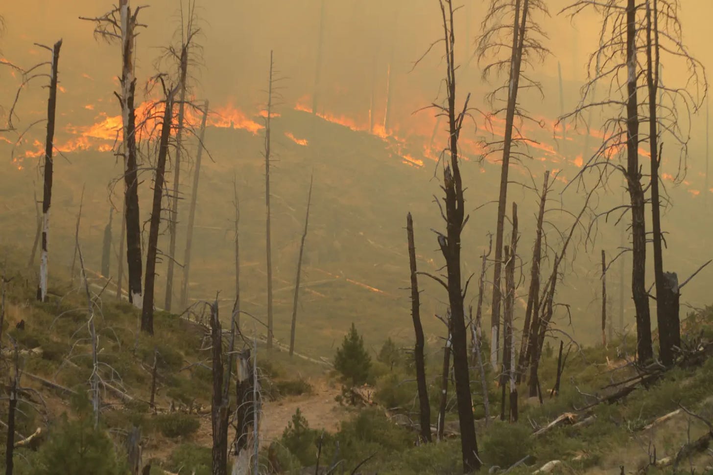
Elevated wildfire risk as Oregon wildfire season off to ‘aggressive start’
A spate of lightning storms coupled with hot dry weather has created high-risk wildfire conditions earlier than expected, officials said
Heat, lightning and wind have conspired to create high-risk conditions for wildfire across southern, central and eastern Oregon far earlier in the summer than state officials anticipated. “We are fighting fire like it’s August 19, not July 19,” said Mariana Ruiz-Temple, Oregon’s state fire marshal, at a news conference Friday. The wildfire season in the Northwest can last from May through October, but typically the season is most intense from July to September. As of Friday afternoon, there were 24 large fires of 100 or more acres burning in parts of Oregon, according to the Northwest Interagency Coordination Center, a wildfire prevention and response network that includes nine state and federal agencies across the West.Statewide emergency
On July 12, Kotek declared a statewide wildfire emergency, which enabled National Guard deployment to parts of the state and allowed state and federal resources to flow to areas in need. “To be very honest, our wildfire season is off to a very aggressive start,” she said. Oregon has received additional equipment and firefighters from Washington, California, New Mexico, Idaho, Montana, Oklahoma, Texas, Georgia, Colorado and Florida, and Kotek expects more wildfire fighters will arrive in the coming days. “I cannot emphasize enough: This is a dynamic, fast-moving situation for our state, and we will continue to use every resource, every person that we can get our hands on, to fight these fires,” she said.For more information on how to prepare for possible evacuation, visit: wildfire.oregon.gov Kotek could not provide details about whether or not the state would exceed its emergency wildfire budget, but indicated costs are adding up. “I can say, it will be more expensive than the last fire season. I think that’s a safe bet,” she said. Global issues with CrowdStrike security software taking down Microsoft systems has not impacted the agency’s work or any wildfire response work in Oregon, Kotek said. Teams from the Oregon State Fire Marshal’s Office, Department of Forestry and the U.S. Forest Service and Bureau of Land Management are working together to protect property and natural resources. Erin McMahon, director of the Department of Emergency Management, said there have been 88 evacuation orders across the state so far this summer. “Our firefighters are working at all hours of the day and night, in conditions that are hard for many of us to fathom,” Kotek said. “It’s going to be a long wildfire season, and we need each and every one of them.” (SOURCE)Monitoring Fires in Oregon
Large Fires in Oregon 7/22/24 7:30am per INCIWEB
| Incident | Type | State | Incident Size | UpdatedSort ascending |
|---|---|---|---|---|
| Falls Fire – ORMAF | Wildfire | Oregon | 132951 Acres | 37 seconds ago |
| Durkee Fire – ORVAD | Wildfire | Oregon | 173758 Acres | 30 minutes 8 seconds ago |
| Lone Rock Fire – ORPRD | Wildfire | Oregon | 116563 Acres | 43 minutes 22 seconds ago |
| Boneyard Fire – OR95S | Wildfire | Oregon | 14602 Acres | 9 hours 32 minutes ago |
| Cow Valley Fire – ORVAD | Wildfire | Oregon | 133490 Acres | 9 hours 34 minutes ago |
| Lane 1 – OR77S | Wildfire | Oregon | 768 Acres | 11 hours ago |
| Red Fire – ORDEF | Wildfire | Oregon | 350 Acres | 11 hours 12 minutes ago |
| Ore Fire – ORWIF | Wildfire | Oregon | 645 Acres | 11 hours 13 minutes ago |
| Diamond Complex – ORUPF | Wildfire | Oregon | 2816 Acres | 11 hours 46 minutes ago |
| Pyramid Fire – ORWIF | Wildfire | Oregon | 500 Acres | 15 hours 57 minutes ago |
| Battle Mountain Complex – OR97S | Wildfire | Oregon | 6408 Acres | 20 hours 42 minutes ago |
| Larch Creek Fire – OR95S | Wildfire | Oregon | 18286 Acres | 2 days 9 hours ago |
| Salt Creek – OR710S | Wildfire | Oregon | 4102 Acres | 4 days 21 hours ago |
| Little Yamsay Fire – ORFWF | Wildfire | Oregon | 6340 Acres | 1 month 3 weeks ago |
| 2023 Chilcoot Fire UNF – ORUPF | Wildfire | Oregon | 1940 Acres | 1 month 4 weeks ago |
| 2023 Chilcoot Fire UNF – ORUPF | Wildfire | Oregon | 1940 Acres | 1 month 4 weeks ago |
| 2023 Ridge Fire UNF – ORUPF | Wildfire | Oregon | 214 Acres | 1 month 4 weeks ago |
| 2023 Ridge Fire UNF – ORUPF | Wildfire | Oregon | 214 Acres | 1 month 4 weeks ago |

Please Help Prevent Wildfires!
In these dry conditions, a single spark can cause a lot of damage. Learn how you can prevent wildfires by visiting the Oregon State Fire Marshal’s wildfire prevention page.

Draft wildfire hazard maps posted for public comment – Oregon Dept. of Forestry
SALEM, Ore. — Draft versions of the statewide wildfire hazard and wildland-urban interface maps are available to the public for review and comment starting today on Oregon State University’s Wildfire Risk Explorer website.
- Educate Oregon residents and property owners about the level of hazard where they live.
- Assist in prioritizing fire adaptation and mitigation resources for the most vulnerable locations.
- Identify where defensible space standards and home hardening codes will apply.
- Adjustments for hay and pasturelands.
- Adjustments for northwest Oregon forest fuels.
- Changes based on draft rules to include irrigation of agricultural crops as a mitigating factor in wildfire hazard assessments. Final maps will reflect rules as adopted by the Board of Forestry.
Report Says Oregon is the 3rd Most Dangerous State
In a recent report, Oregon has been identified as the 3rd most dangerous state in the U.S., shedding light on concerning crime trends within its cities. Among these cities, Roseburg, OR, stands out as a focal point for understanding the challenges faced in the state. The report delves into the intricacies of crime rates, highlighting the need for a comprehensive analysis of safety and security measures.
Recently timeout.com listed the best parks in the United States and Oregon was the only state in the Northwest that made it to the top 10.

After 30 years, one of Oregon DOC’s Most Wanted Fugitives has been arrested in the state of Georgia
An Oregon Department of Corrections (DOC) adult in custody who fled from a work crew in 1994 is back in custody. Steven Craig Johnson fled from a work crew at the Mill Creek Correctional Facility (MCCF) in Salem on November 29, 1994.
Oregon’s Unemployment Situation Sees Little Change

Average gasoline prices in Oregon have fallen 4.9 cents per gallon in the last week, averaging $3.90/g today, according to GasBuddy’s survey of 1,307 stations in Oregon.
- Eugene- $3.71/g, down 4.0 cents per gallon from last week’s $3.75/g.
- Salem- $3.84/g, down 6.7 cents per gallon from last week’s $3.90/g.
- Portland- $4.05/g, down 4.5 cents per gallon from last week’s $4.09/g.
Governor Kotek proposes changes to Oregon school funding and half billion dollar boost in next budget
The proposal aims to narrow district funding gaps caused by rising costs and an end of extra federal funding in September
With Oregon’s public schools staring down a fiscal cliff this school year as the historic federal investment from the last few years expires, Gov. Tina Kotek is proposing changes. She’d like to help schools keep up with rising costs in the years ahead by updating the way schools are funded. She estimates that those changes would bring a $515 million boost to the State School Fund during the 2025-27 school years. The state’s 197 school districts have spent nearly all of their portions of the $1.6 billion in federal COVID relief money awarded to the state since 2020. The money expires in September and with it, some of the services, programs and staff that it has paid for. “Across the country, school districts are facing budget shortages caused by the expiration of federal pandemic relief dollars, declining enrollment, increasing costs due to inflation and many other factors,” Kotek said in a news release Wednesday announcing the changes. They come amid growing calls for funding help from districts. After teachers in the state’s largest district, Portland Public Schools, went on strike for more than a month last fall – in part because of low pay and poor working conditions – Kotek vowed she would review school funding and compensation issues in Oregon. Leaders in other big districts also issued warnings about their dire budget predicaments following the strike, and in May, several superintendents released a video calling school funding in the state a “crisis” as they explained their decisions to cut hundreds of jobs to keep schools solvent. They implored the Legislature to increase education spending.Years of underfunding
During the long legislative session in 2023, lawmakers passed a $10.2 billion school funding package, the largest public K-12 education budget ever allocated in Oregon. Of that, more than $8.8 billion went to the State School Fund, which pays for the bulk of district budgets. But school leaders afterwards said that was still not enough following years of underfunding and rising costs due to inflation. Legislators have historically not fully allocated to schools the amount recommended by the state’s Education Quality Commission, which is tasked with ensuring Oregon operates “a system of highly-effective schools” and presents a proposed budget to the governor and the Legislature every two-years. Oregon school funding has further been stymied by two voter-approved ballot measures passed in the 1990s that have capped the state’s ability to tax property to fund schools. School funding from property taxes dropped by two-thirds in the following years, with the Legislature drawing a greater share of funding from the state’s general fund, which is needed for myriad services in the state. Sen. Michael Dembrow, D-Portland, chair of the Senate Education Committee and the Statewide Educator Salary Task Force formed by the Legislature in 2023, said improvements to the State School Fund are desperately needed. But he said he’s concerned about where the additional money will come from with no new tax increases or revenue streams proposed alongside them. “It’s an open question as to what else in the budget might have to be cut in order to bring in this extra half a billion dollars,” he said. “Personally, I worry that it could come from higher education, which is already very much underfunded.”Proposed changes
The first change Kotek proposes to the State School Fund is to give schools 49% of their allocated budget in the first year of the two-year budget cycle, and then the remaining 51% in the second year, rather than splitting them evenly each year. She said this would help boost funding in subsequent two-year budgets since they are based on the amount allocated for the second year of the previous education budget. This would also help schools cover expenses that might be higher by the second year of a two-year budget. This change would give districts at least $217 million more in their 2025-27 budgets, Kotek’s advisers estimate. The second proposed change would involve data the state uses to project future compensation. By narrowing the data the state uses for its projections – using the last 10 years of salary data instead of 20 – about $500 million would be added to the money available to schools to hire teachers and classified and administrative staff in the 2025-27 budget. Lastly, Kotek proposes that the Legislature incorporate annual changes in local property tax revenues. Historically, the Legislature has only taken into account revenue from the first year of a biennial budget when considering what to allocate in the next budget. This limits the state’s ability to send schools more money if property tax revenues rise during a year that’s not counted. By accounting for local revenue changes every year, state officials could bring in an additional $55 million to the State School Fund for the 2025-27 school year, Kotek’s office estimated. “The governor said she was committed to this, and she is showing that she is,” Dembrow said of the latest changes. “Looking at how this gets funded in her budget, which will come out in December, will be really interesting to see, because obviously that’s where the proof in the pudding will be.” (SOURCE)Bags of rice recalled in seven US states as they may contain ‘rodent parts’
Wehah Farms has issued a recall of 4,600 cases of its Lundberg Family Farms Sustainable Wild Blend Gourmet Rice in seven states . This is due to the potential presence of a “foreign object that appears to be of rodent origin.”
The Oregon Coast Aquarium New Tufted Puffin Oregon License Plates on Sale
One of Oregon’s most adorably iconic seabirds is coming to the front and back of a car near you. The Oregon Coast Aquarium has opened voucher sales for its new tufted puffin license plates.


