The latest news stories of interest in the Rogue Valley and the state of Oregon from the digital home of Southern Oregon, Wynne Broadcasting’s RogueValleyMagazine.com
Monday – August 25, 2025
Rogue Valley Weather

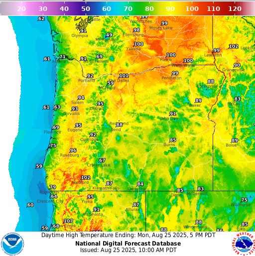
https://graphical.weather.gov/sectors/oregon.php
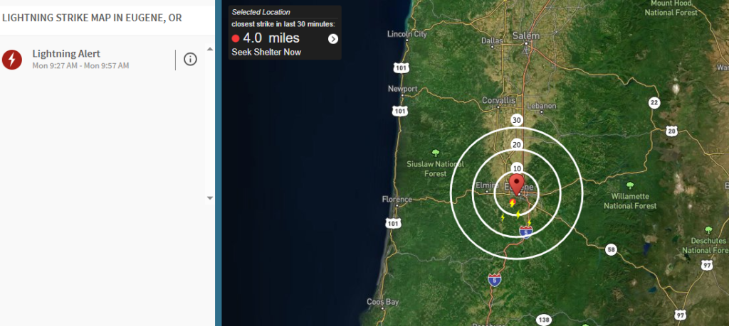
Daily rounds of thunderstorms will continue across Southern Oregon and far northern California through Wednesday, bringing the risk of lightning, hail, and new fire starts.
The most active storms are expected east of the Cascades, though Jackson, Josephine, and Siskiyou counties could also see storm activity overnight.

According to the National Weather Service in Medford, storms will be capable of producing gusty winds, heavy downpours, and small hail. Frequent lightning strikes are possible each afternoon and evening, with the strongest storms capable of sparking wildfires in dry fuels across southern Oregon.
Communities including Medford, Grants Pass, Ashland, and Klamath Falls should prepare for rapidly changing conditions. Outdoor recreation areas such as Crater Lake National Park and mountain lakes are at higher risk for dangerous lightning strikes. Residents are urged to avoid exposed summits, ridgelines, or large open fields if storms develop.
Travelers along Interstate 5 and Highways 62 and 97 may face sudden downpours reducing visibility. Authorities recommend delaying outdoor plans when thunder is heard and waiting 30 minutes after the last rumble before resuming activities.
Thunderstorm chances will remain elevated through Wednesday, with additional watches and warnings possible if fire activity increases.

U.S. Forest Service- Rogue River-Siskiyou National Forest – WILDFIRE UPDATE 08/25/25 9:30 AM


U.S. Forest Service – Umpqua National Forest
Firefighters are responding to several reports of new fires on the north zone of the Forest. A widespread lightning storm has moved and will continue to move across the Forest, multiple strikes have been confirmed.
-*New Start* Sugar Loaf (#345) – Estimated at eight acres just east of Sugarloaf Mountain on the Cottage Grove Ranger District. Two engines, two individual resources, and a dozer on scene. Air resources are also supporting this fire.
-*New Start* Eva (#343) – Estimated at 0.28 of an acre. Located just east of Mud Lake Mountain in the Diamond Lake Ranger District. Two engines, rappelers and an individual resource on scene. Air resources are also supporting this fire. 60% lined.
-*New Start* French (#339) – Estimated at one-tenth of an acre. Located just east of Mud Lake Mountain in the Diamond Lake Ranger District. Wolf Creek Job Corps Suppression Module on scene. Air resources are also supporting this fire. 100% lined, contained.
-*New Start* Jack (#336) – Estimated at one-tenth of an acre. Located just east of Jacks Saddle along National Forest Service Road #2358 on the North Umpqua Ranger District. Two engines on scene. Fire is lined, controlled.
-*New Start* Camas (#334) – Estimated at 0.2 of an acre. Located just east of the Mount Bailey Trailhead near Eva Creek on the Diamond Lake Ranger District. One Umpqua engine and one Fremont-Winema Engine on scene. Air resources are also supporting this fire. Two-thirds contained.
-*Smoke Check* Canton (#347) – Unable to locate, east of Saddle Camp Butte on the North Umpqua Ranger District.
– Emerson (#328) – August 24 start on the Tiller Ranger District – contained.
We will update with more details as soon as they become available. Smoke reports can be reported to Roseburg Interagency Communications Center at (541) 957-3325 or 911.
Please remember that flying drones near wildfires is not safe – if you fly, we can’t.
𝗙𝗶𝗿𝗲 𝗥𝗲𝘀𝘁𝗿𝗶𝗰𝘁𝗶𝗼𝗻 𝗜𝗻𝗳𝗼𝗿𝗺𝗮𝘁𝗶𝗼𝗻
– The Forest is in HIGH Fire Danger
– Public Use Restrictions Level 2 – Fires in Forest Service-constructed fire rings and fireplaces in designated sites.
– Industrial Fire Precaution Level remains at Level 2
Do your part to reduce the number of human-caused wildfires. Remember that even fires in Forest Service-constructed fire rings within designated recreation sites, need to be dead out before leaving your campsite. Drown, stir, and feel your campfire with the back of your hand. It should feel cold to the touch before leaving your campsite
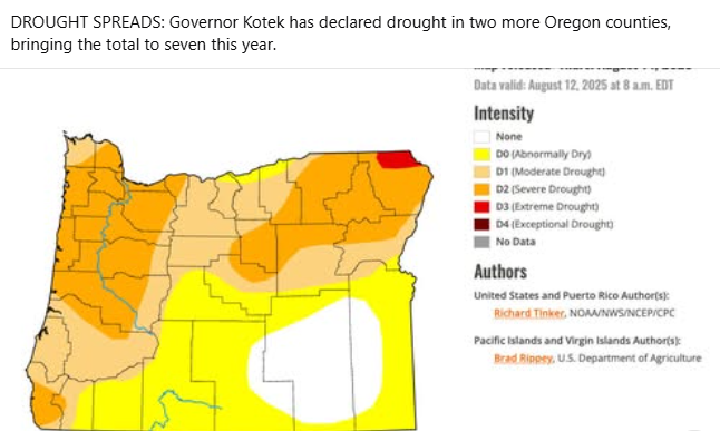
ODF Southwest Oregon District – Fire Danger Level Extreme in Jackson and Josephine Counties
Due to dry vegetation, fire behavior, and consistent hot and windy conditions, the fire danger level on lands protected by the Oregon Department of Forestry in Jackson and Josephine counties increased to “extreme” (red) at 12:01 a.m. on Tuesday, August 12, 2025. These regulations impact 1.8 million acres of state, private, county, city and Bureau of Land Management lands protected by ODF’s Southwest Oregon District. The Industrial Fire Precaution Level (IFPL) will remain at two (2).
The following public fire restrictions are in effect:
- The use of power saws is prohibited, excluding electric chainsaws.
- The cutting, grinding and welding of metal is prohibited.
- The mowing of dry or dead grass is prohibited. This includes lawnmowers, weed eaters, and any other type of grass-trimming equipment. The mowing of green lawns is allowed at any time.
- The operation of any other spark-emitting internal combustion engine not specifically mentioned above is prohibited.
The following fire prevention regulations are currently in effect and will remain in effect until the fire danger level drops significantly:
- Debris burning, including the use of burn barrels, is prohibited
- Open fires are prohibited, including campfires, charcoal fires, cooking fires and warming fires, except in approved fire rings at designated campgrounds. In other locations clear of dry vegetation, portable cooking stoves using liquefied or bottled fuels are allowed.
- Smoking is prohibited while traveling, except in vehicles on improved roads, in boats on the water, and designated locations.
- Fireworks on or within 1/8th of a mile of ODF-protected land are prohibited. Fireworks are also prohibited on all BLM lands.
- Any electric fence controller in use shall be listed by a nationally recognized testing laboratory or be certified by the Department of Consumer and Business Services; and operated in compliance with the manufacturer’s fire-safe instructions.
- The use of exploding targets is prohibited.
- The use of tracer ammunition or any bullet with a pyrotechnic charge in its base is prohibited.
- Motor vehicles, including motorcycles and all-terrain vehicles, may only be used on improved roads free of flammable vegetation, except when used for the commercial culture and harvest of agricultural crops.
- Possession of the following firefighting equipment is required while traveling, except on state highways, county roads and driveways: one shovel and one gallon of water or one 2.5 pound or larger fire extinguisher. All-terrain vehicles and motorcycles must be equipped with one 2.5 pound or larger fire extinguisher.
The US National Weather Service Medford office has issued an Extreme Heat Warning across southern Oregon, in effect now through Wednesday at 2 a.m. due to triple digit temperatures up to 110 degrees. These conditions, in combination with dry vegetation, naturally promote fire growth. Be aware of the increased risk and prevent fires by following the current regulations, found here: https://swofire.com/public-fire-restrictions
For more information about the Oregon Department of Forestry Southwest Oregon District’s fire season regulations, visit our website, www.swofire.com

ODF Southwest Oregon District -𝙇𝙄𝙂𝙃𝙏𝙉𝙄𝙉𝙂 𝙁𝙄𝙍𝙀𝙎 𝙍𝙀𝘾𝘼𝙋
Following thunderstorms last night, approximately 130 lightning strikes struck ODF-protected land up the eastern side of Jackson County, with even more on our partners at U.S. Forest Service- Rogue River-Siskiyou National Forest. Due to active thunder cells, we could only put up a reconnaissance flight for a short time, just before dark near the Prospect area. Our air attack platform was able to spot a few small fires on Forest Service land in that area, all around 1/100 of an acre.
With two fires close to private land, we sent resources to investigate. One, dubbed the Sunshine Fire, couldn’t be found. The Highway 140 Mile Marker 21 Fire was located after a couple hours of hiking. Firefighters estimate it’s a half-acre on 90% slope with the majority of the fire being a large, hazardous tree. Tree fallers will be heading out early this morning to fall it and allow firefighters to extinguish the entirety of the fire. An engines stayed out with it all night to control any further spread in the meantime. Two additional fire reports in the Greensprings area couldn’t be located.
This morning, a new recon flight will be conducted across the entire affected strike area. Lightning fires typically begin to grow in warmer conditions, so numerous flights will be made throughout the day as temperatures heat up. Our Detection Center staff will also be scanning these areas all day, and engines will be in their patrol areas to allow for a fast response. All days off have been canceled, bringing in every resource we have.
The US National Weather Service Medford Office has issued an Extreme Heat Warning for much of Jackson and Josephine counties today, ending at 8 p.m., as well as another Red Flag Warning for the lightning-affected area from 1 – 8 p.m today with more thunderstorms in the forecast. These conditions can hamper our efforts just as much as potential rain could help; hot, gusty winds that come with these storms can limit our ability to use aircraft and naturally increase fire behavior.
Additionally, we responded to an illegal burn last night. Even with rainfall, debris burning in any form is extremely dangerous with the hot and windy conditions we’re currently experiencing; burns can easily reignite, and you may not be home when that happens to extinguish and report it.
Help prevent new fires from starting, especially while firefighters are engaged on incidents caused by lightning that couldn’t have been prevented. The regulations put in place by ODF are all the most common reasons why human-caused fires start. You find them all here: https://swofire.com/public-fire-restrictions/


Grants Pass police cleared homeless encampments last week at Baker and Kesterson Parks, directing residents to leave public property.
A lawsuit filed by Disability Rights Oregon had temporarily blocked Grants Pass from clearing some park encampments. The temporary injunction was lifted after settlement was reached Thursday, Aug. 14.
Residents at both parks received notices Saturday, Aug. 16, ordering them to leave the property by Tuesday morning. The campers were instructed to make their way to the three city-sanctioned sites downtown.

Police and city vehicles idle in Baker Park in Grants Pass during the clearing of a homeless encampment on Tuesday, Aug. 19, 2025.
As part of the settlement, Grants Pass is required to ensure the sites have shade, drinkable water and comply with the Americans with Disabilities Act.
Grants Pass police officer Lucas Six arrived at Kesterson Park at 7 a.m. Tuesday. He said police could not guarantee residents would move to the provided sites, since leaving the city was also an option.
“They have their own rights as citizens,” he said. “They can choose to leave the area if they prefer.”
Moving from one site to the next is difficult for many residents.
Tess Rightbower, who moved to Kesterson Park in June after Lawnridge Park was swept, said residents were at risk of losing everything they owned if they couldn’t move it all in one trip.
“We have one of us stay because if we leave our stuff for a minute, it’s gonna be gone,” she said. “It makes it really hard to move.”
The notice at Kesterson Park warned that unattended property “will be considered abandoned and disposed of.” Community safety officers loaded abandoned tents into trucks to be carried off while other residents continued packing on the other side of the park.
The Grants Pass City Council is set to award a grant of more than $1.2 million to an organization that will carry out the settlement terms. The council is weighing four applicants and has its next workshop scheduled for Sept. 2. (SOURCE)
Pacific Flats in Phoenix is Now Leasing Apartments

Community leaders, partners, and residents celebrated the opening of the 72-unit multifamily community at 4019 South Pacific Highway last month. The affordable housing project was co-developed by Commonwealth Development Corporation and NOWIA Unete.
Its focus is on giving low-income families a place to call home, while also partnering with ACCESS and Unete to provide 2020 fire survivors a path to find adequate housing.
Pacific Flats is an income restricted property. Residents must meet these income limits to qualify for homes at Pacific Flats. Section 8 vouchers are accepted.
The community includes a clubhouse with amenities such as a community room, business center, and fitness center. The property is now leasing two- and three-bedroom apartments equipped with energy-efficient appliances. Those interested in applying can visit cascademanagement.com.
Grants Pass Man Indicted for Months-long Burglary Series
– Between September 2024 and January 2025, the Grants Pass Police Department began investigating several commercial burglaries occurring within the city.
Not only were the businesses burglarized, but items valued between $100 and $1000 were taken, and property was intentionally damaged, in some cases adding up to more than $1000. The following businesses were victims of the burglary series:
- Bi Mart (Victimized twice)
- Cash Connection (Victimized twice)
- Highland Market
- Rogue Fly Shop
- Batteries Plus Bulb
- M Street Market
- Lucky Duck on Redwood Ave.
- Farmers Building Supply
- Don’s Bike Center
- Fields Home Improvement (in Josephine County)
During the months-long investigation, Anthony Boyd Mooney, a 33-year-old male of Grants Pass, was identified as the suspect. Last week, a Grand Jury panel heard testimony and indicted Mooney on the following charges:
- 12 counts of Burglary in the Second Degree
- 5 counts of Theft in the First Degree
- 11 counts of Criminal Mischief in the First Degree
- 7 counts of Theft in the Second Degree
The whereabouts of Anthony Mooney are currently unknown, but he has several warrants for his arrest. Anyone with information on Mooney’s location should contact their local law enforcement agency to facilitate his arrest.
The Grants Pass Downs is poised to commence its fall racing season with a 12-day meet beginning on Sunday, September 7.
As stated by the Horseman’s Racing Association, this event will present a combination of competitive racing, community activities, and family-oriented entertainment extending through mid-October. The Opening Day will highlight the Daily Courier Stakes and the Southern Belle Stakes, generating excitement at the track. Additionally, the season will feature Monday evening races accompanied by a “Twice the Fun for the Price of One” promotion, starting on September 8.
On September 14, the track will host the Rex on the Rogue Dino-Races, a fundraising initiative aimed at supporting children who are battling cancer in Josephine County. A week later, on September 21, Ladies Hat Day will take place, allowing women wearing hats to gain free admission and compete for prizes across various categories. Community involvement will continue on September 28, with free entry available to patrons who donate canned goods to the Josephine County Food Bank.
Oktoberfest, scheduled for October 5, will introduce Bavarian elements with commemorative pint glasses and tastings.
Four Year Old Girl Killed in Vicious Dog Attack in Josephine County

The Josephine County Sheriff’s Office is currently investigating the death of a 4-year-old girl following a dog attack that occurred on Saturday afternoon.
Authorities responded to a 911 call reporting a dog attack on the 1800 block of Laurel Road. Law enforcement, along with AMR and the Illinois Valley Fire District, arrived on the scene and attempted lifesaving measures; however, the child was sadly pronounced dead at the location.
The dog involved, identified as a mix of Cane Corso, Rottweiler, and Pit Bull, has been taken into custody by Josephine County Animal Control. The name of the child will not be disclosed. The investigation is ongoing, and no additional information is currently available.
MISSING PERSON: Raven Alexis Baysinger
CASE: 25-18739
AGE: 32
SEX: Female
RACE: White
HEIGHT: 5’6″
WEIGHT: 145
HAIR: Brown
EYES: Brown

INFORMATION: On 08/15/2025 Raven was reported as a missing person. Raven was last seen at Griffin Park in May 2024 and has not been seen or heard from since. Raven is believed to possibly be in the area of Wilderville or Grants Pass. The above photo is about a year old.
If you have any information, please contact the Josephine County Sheriff’s Office at 541-474-5123.
The Ashland School District has been forced to move several programs out of a 99-year-old facility after an inspection by the city fire marshal uncovered severe structural problems.

Ashland.news reports that because of the emergency closure of Lincoln School, the alternative education program “Thoreau and Catalyst,” as well as two other specialized programs, Ashland Schools Foundation, the district’s wellness center, and use of the gym for high school club wrestling practices will need to relocate.
Joseph Hattrick, superintendent of Ashland School District, said the district is developing a plan to help teachers remove their materials safely.
“As superintendent of the school district, as fire marshal, we both agreed that life is far more important than risks,” Hattrick said, “which is why we’re not willing to take a risk. We’re not willing to gamble on this decision.”
After the inspection uncovered potential structural problems, Chris Brown, principal architect at Arkitek, was brought in help assess the situation. He said he noticed a “significant shift” of about 2 to 3 inches in the building. .
“That shift could potentially lead to catastrophic failure of the building in its entirety,” he told the school board.
The original Lincoln School building was constructed in 1926 and the most recent addition was built in 1961, according to school board records. Lincoln School closed in 2005 because of declining district enrollment.


Volunteers are being sought for a range of activities, including a Naturalization Ceremony, project weekend, Ride the Rim, and the group’s annual meeting.
For further information and/or to register, please contact Karen Walters at karen@friendsofcraterlake.org. Volunteers are needed.
Volunteers are also required for the annual Rim the Rim event, during which 25 miles of East Rim Drive, from its junction with the North Entrance Road to park headquarters, will be closed to motorized vehicles from 8 a.m. to 4 p.m. on two Saturdays, September 6 and 13. This event presents challenges due to significant elevation gains. For additional information and to register, please contact Ann McCaughan at ann@friendsofcraterlake.org.
The Fair May Be Once a Year… But Fair School is All Year Long!
From bacon to bread, jams to jerky — learn from the people who know their stuff.
(1).png&cb=6367c14a)
Class Line-Up:
Sept 13 – Bacon & Sausage Basics
Oct 11 – Canning Meat
Nov 8 – Gifts from the Kitchen
Dec 6 – Basic Candy Making
Jan 10 – Soup & Bread Making
All classes held in the Community Education Auditorium.
Registration required — sign up now on the Fairgrounds website!
www.josephinecountyfairgrounds.com/fair-school
 Young Entrepreneurs of Jackson County! Did the 2020 wildfires set your business back? Need a boost to grow your hustle?
IVCanDO has grants of up to $15,000 for microbusinesses (5 or fewer employees) impacted by the fires.
Whether you’re running a shop, creative studio, food truck, or anything in between — this is for YOU.
𝗘𝗹𝗶𝗴𝗶𝗯𝗶𝗹𝗶𝘁𝘆:
Must be in Jackson County
Must have been affected or be addressing impacts caused by the 2020 Labor Day fires (South Obenchain and Almeda)
Use the money for gear, staff, or anything to level up your biz
𝗔𝗽𝗽𝗹𝗶𝗰𝗮𝘁𝗶𝗼𝗻𝘀 𝗼𝗽𝗲𝗻 𝗡𝗢𝗪. 𝗗𝗼𝗻’𝘁 𝗺𝗶𝘀𝘀 𝗶𝘁!
𝗔𝗽𝗽𝗹𝘆 𝗮𝘁: www.ivcdo.org/pier
𝗤𝘂𝗲𝘀𝘁𝗶𝗼𝗻𝘀? 𝗗𝗠 𝘂𝘀 𝗼𝗿 𝗲𝗺𝗮𝗶𝗹 𝗽𝗶𝗲𝗿@𝗶𝘃𝗰𝗱𝗼.𝗼𝗿𝗴
The Illinois Valley Community Development Organization (IVCanDO) has received $950,000 through Oregon Housing and Community Services’ PIER Program as part of the ReOregon disaster recovery effort.
Sharing for our friends at Salvation Army:
The Addictions Recovery Center (ARC) in Medford is expanding its services with a new facility which is currently under construction. This will add 24 residential treatment beds to the ARC’s East Main Campus. See Video and Follow on Facebook: https://www.facebook.com/ARC541/videos/520525737735442
Ashland Rolls Out Free Pre-Approved Plans to Spur Residents into Building Affordable Backyard Homes
Seeking to promote affordability and support residents’ diverse needs, the city of Ashland has encouraged its citizens to develop accessory dwelling units (ADUs) within the city and offers guidance on getting plans approved.
The City of Ashland has streamlined the ADU application process to enhance housing options. It now offers a complete set of pre-approved ADU plans that meet local building codes for free to Ashland property owners.
To get ADU plan approval in Ashland, the Ashland Planning Division offers a free consultation. At the meeting, a City Planner will review your site and provide valuable guidance on the permit application process. The meeting is geared towards helping you understand zoning requirements, building codes, and any other considerations for ADU projects. Find free City of Ashland ADU plans here
Sheriff’s Office issues advisory about motorhome and possible link to missing Prospect woman Deenah Padgett
The Jackson County Sheriff’s Office (JCSO) is asking for help identifying the owner a motorhome. It could be associated with a missing person from the Prospect area. JCSO says 68-year-old Deenah Padgett has been missing since August 30 from Prospect, described as a white woman, 4’ 8” tall, weighing approximately 95 pounds with brownish red/greying hair. JCSO issued an advisory this weekend asking anyone with information about the owner of the pictured motor home or Padgett’s whereabouts to call Emergency Communications of Southern Oregon (ECSO) dispatch non-emergency phone number at 541-776-7206.

Did you get help from FEMA, insurance, or others after the 2020 Almeda and South Obenchain Fires?
OHCS HARP Website → bit.ly/45bHjzu
David Grubbs’ Murder Investigation Remains Active
 The Ashland Police Department’s investigation into the murder of David Grubbs on November 19, 2011 remains open and active. Recently two new detectives have been assigned to look into new leads that have come in.
It’s Been Five Years Since Fauna Frey Vanished Without A Trace In Josephine County

It’s been five years since the disappearance of a Lane County Woman, who was last seen in Grants Pass. Back in June of 2020, Fauna Frey disappeared. Police said the 45-year-old left her home in Dexter to drive to Grants Pass to visit her brother’s friend after her brother had recently passed away. The last place she was seen was at the Big 5 in Grants Pass. Investigators said her car was found in the Galice area months later. The circumstances of Fauna’s disappearance remain unclear and her case is currently classified as missing. Her case remains unsolved. Fauna’s disappearance has been featured on multiple investigative podcasts, including Nowhere to be Found, Here One Minute, Gone the Next, and Detective Perspective, each trying to fill the silence left by law enforcement. New listeners continue to discover her story, hoping a fresh set of eyes or a single loose memory might be the key to finding Fauna.
Have Information on Fauna Frey? Please Speak Up!
If you know anything, no matter how small, please contact:
- Josephine County Sheriff’s Office
- Tip line: (541) 359-5638
- Email: FindFaunaFrey@gmail.com
Currrently there is a $50,000 CASH REWARD for information leading to the location of Fauna Frey. LARGE CASH REWARDS are being offered for any other relevant information, such as any objects that could be identified as Fauna’s, i.e. her wallet, keys, or Indian/Buffalo .999 silver bullion coins. Find Fauna Frey Facebook Group: https://www.facebook.com/groups/341658526970132
PART 2 – Newsweek Podcast Focusing on The Disappearance of Fauna Frey From Lane County

Here One Minute, Gone the Next —– PART 2 – Josephine County Sheriff Dave Daniel joins investigative journalist Alex Rogue to speak with Here One Minute, Gone the Next about the disappearance of Fauna Frey, the growing friction between citizen investigators and law enforcement, and the lack of resources in missing persons cases. https://podcasts.apple.com/us/podcast/the-disappearance-of-fauna-frey-pt2-feat-sheriff/id1707094441?i=1000630100040 PART 1 – John Frey joins Newsweek to discuss exclusive details about the case of his missing daughter that until now have been unavailable to the general public. READ MORE HERE: https://www.newsweek.com/exclusive-what-happened-fauna-frey-new-clues-uncovered-1827197?fbclid=IwAR3Z3Glru5lIgqiYXbs_nA1Fj8JuCIzM11OHSVHfwIucfq2f_G5y9y5bnmQ If you have any information on the whereabouts of Fauna Frey, call the anonymous tip line at 541-539-5638 or email FindFaunaFrey@gmail.com. —- Help Find Fauna Frey #FindFaunaFrey FACEBOOK GROUP
 Families: The deadline for applications to the EBT Nutrition Program for Kids is September 3rd.
Families that meet the eligibility criteria can receive 120 dollars per child to assist with food expenses during periods when school nutrition programs are not in operation. Most qualifying school children received their benefits on May 22nd; however, families that did not automatically receive benefits can apply to determine their eligibility.
To learn more:
- Call 833-ORE-SEBT (833-673-7328). The call center is open Monday through Friday, 8 a.m. to 5 p.m. Pacific Time.
- Visit sebt.oregon.gov.

The Oregon Summer EBT (electronic benefit transfer) program helps families buy food for their school-aged children when school is out. Each summer, eligible families will get one yearly payment of $120 to buy groceries. Learn who is automatically eligible and who needs to apply at sebt.oregon.gov. Questions? Please contact the Summer EBT Call Center at 1-833-673-7328 or summerebtinfo@odhs.oregon.gov.
Oregon Food Bank

Hunger in Oregon is rising — and federal and state cuts to food assistance are making it worse. In 2024, visits to food programs grew 31%, yet resources to meet this need are shrinking.
Programs like SNAP, which help 1 in 8 Oregonians put food on the table, are facing deep cuts — leaving more families, children, veterans, and elders to make impossible choices between food, safety, and shelter.
We need policies that protect access to food for all our neighbors. Because no one should have to choose between staying safe and going hungry.
Food is available for those who need it and by entering your zip code at OregonFoodFinder.or -You can see each local program’s contact information, hours of operation and what kind of distribution it is.
We partner with 1,200+ free food markets, pantries and meal sites all across Oregon and Southwest Washington — and welcome anyone and everyone who needs food. OregonFoodFinder.org

Portland Grade School Forced to Move Due to ‘Unsafe’ Tear Gas and Munitions from Neighboring ICE Facility
A Portland grade school says it’s relocating due to dangerous and violent conditions a local ICE facility has caused amid its aggressive responses to protesters outside their building.
:max_bytes(150000):strip_icc():focal(749x0:751x2):format(webp)/the-cottonwood-school-082225-ccdda5b199d3464cb83ad680b59556c7.jpg)
A news article shared by People further shows us what this Portland school is up against. Apparently, Cottonwood School, a grade school in Portland, is temporarily relocating away from its campus. This is happening because there are nearby violent conditions at a local ICE facility due to ICE continually using large amounts of tear gas in the neighborhood. Now, neighbors are complaining about the toxic gas making its way into the local community.
The Cottonwood School, located in Portland is calling its relocation an “emergency move,” according to an automated response PEOPLE received from a school official’s email account. (READ MORE)
Fire Safety & Energy Conservation – High heat increases fire danger and strains the power grid. Prevent Wildfires

- Follow local burn bans
- Use fireworks responsibly
- Report unsafe conditions immediately
Please remember… All it takes is a spark
8/25 – #OregonFires
![]() FIRES in EVALUATION MODE:
FIRES in EVALUATION MODE:![]() 29 Oregon Wildfires
29 Oregon Wildfires ![]() – many are silent fires ( listed below) 1 to 3 acres. These silent fires can quickly turn into dangerous fires. Please stay alert and ready.#deschutescounty#JeffersonCounty FLAT FIRE
– many are silent fires ( listed below) 1 to 3 acres. These silent fires can quickly turn into dangerous fires. Please stay alert and ready.#deschutescounty#JeffersonCounty FLAT FIRE ![]() EVACUATION: LEVEL 3
EVACUATION: LEVEL 3 ![]() GO NOW
GO NOW![]() – LEVEL 1 and 2 as well.
– LEVEL 1 and 2 as well.![]() 1 LANE COUNTY FIRE
1 LANE COUNTY FIRE ![]() Scharen Rd
Scharen Rd ![]() Last update “ “Forward progress stopped” means that the advancing front of a wildfire is no longer spreading, indicating that firefighters have successfully contained its movement in a specific direction. However, it does not mean the fire is completely extinguished or controlled yet.”Silent Fires and Evacuations can change very quickly, so please stay alert
Last update “ “Forward progress stopped” means that the advancing front of a wildfire is no longer spreading, indicating that firefighters have successfully contained its movement in a specific direction. However, it does not mean the fire is completely extinguished or controlled yet.”Silent Fires and Evacuations can change very quickly, so please stay alert ![]() and safe. WILDFIRE MAP:
and safe. WILDFIRE MAP: ![]()
![]()
![]()
![]() https://www.arcgis.com/apps/instant/portfolio/index.html…
https://www.arcgis.com/apps/instant/portfolio/index.html…
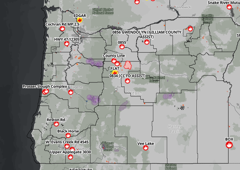
WILDFIRE MAP: https://www.arcgis.com/apps/instant/portfolio/index.html…
Nearly 80% of all fires this season have been attributed to human or undetermined causes; the rest were determined to be started by lightning. A large fire is considered any wildfire that burns more than 100 acres in timber or 300 acres of grassland and brush. As always, for the latest fire information visit the NWCC fire website.
If you see a fire call 911. Also if you are a witness to the start of a fire and can provide information, eye-witness statements, video, photos or any other data, you can assist investigators by emailing them to etips@odf.oregon.gov“>odf.firetips@odf.oregon.gov. This information helps our investigators in creating a full picture of what happened and identify a responsible party if there is one.
![]() Sign up for emergency alerts
Sign up for emergency alerts ![]() Follow evacuation orders immediately
Follow evacuation orders immediately ![]() Don’t park on dry grass
Don’t park on dry grass
![]() Keep 30 feet of defensible space around your home
Keep 30 feet of defensible space around your home ![]() No outdoor burning or fireworks
No outdoor burning or fireworks
Two Wildfires Burning in Lane County After Lightning
The estimated 300-acre Emigrant Fire in the Willamette National Forest is burning southeast of Oakridge. The estimated 8-acre Sugar Loaf Mountain fire, in the Umpqua National Forest, is burning southwest of Oakridge and to the east of Cottage Grove.
Hot, dry, and windy conditions contributed to the growth of the fires, according to the U.S. Forest Service. Air resources are responding to both of the fires alongside ground crews.
Firefighters are engaged in a full suppression response to the Emigrant Fire that started yesterday on the Middle Fork Ranger District following lightning that rolled across the central Cascades. Driven by hot, dry and windy conditions, the fire grew quickly and is now estimated at 1,200 acres burning on steep slopes in a heavily snagged area within the 2009 Tumblebug Fire scar.
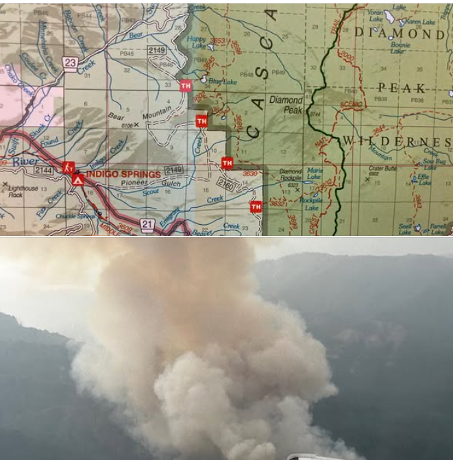
The fire is located in a remote area approximately 3 miles southwest of Indigo Springs Campground. Resources responding include crews, air attack, helicopters, and various large equipment with additional resources en route. Today, firefighters will be scouting options for fireline construction and improving containment lines previously used in the 2009 Tumblebug Fire.
An Infrared Flight was conducted this morning and provided updated information about the size and location of the fire. Given the continued hot, windy and unstable conditions accompanying today’s thunderstorms, additional fire growth is expected. These conditions also make it challenging for firefighters to take action directly along some portions of the fire’s edge. A Complex Incident Management Team is being in-briefed this evening and will assume management of the fire tomorrow.
Smoke is visible in the vicinity of the fire and may settle into nearby drainages overnight. Smoke and air quality information is available at https://www.oregonsmoke.org/ and https://www.lrapa-or.gov/air-quality-protection/current-aqi/. Visitors are asked to avoid the area for public and firefighter safety. Please remember to be check for and follow all fire restrictions when visiting the Willamette National Forest at https://www.fs.usda.gov/r06/willamette/fire.
A link to Executive Order 25-19 can be found here.
Fire Season INFO to Know
All Oregon Department of Forestry (ODF) districts are in fire season. This means that to reduce the risk of human-caused wildfires, fire restrictions may be in place where you live or at a destination you plan to visit or recreate.
Here are some links regarding fire info for mainly Oregon.These links are very important and are updated daily.
* Northwest Coordination Centerhttps://gacc.nifc.gov/nwcc/fire_info.php…
* Central Oregon Fire Info Bloghttps://centraloregonfire.org/
* Lane County/Oregon Fire Updates – FB Pagehttps://www.facebook.com/groups/650665385833845
* Oregon Fires 2025 FB pagehttps://www.facebook.com/groups/1481912815460351
* South Central Oregon Fire Management Partnership – SCOFMPhttps://www.facebook.com/SCOFMPFIREINFO
* US Forest Service – Deschuteshttps://www.facebook.com/deschutesnationalforest
* Rouge Weather – THE DAILY WILDLAND FIRE BRIEFINGhttps://www.facebook.com/RogueWeatherNow…
* Wildfire Trackerhttps://projects.oregonlive.com/wildfires/map
* Watch Duty websitehttps://www.watchduty.org/
* Watch Duty FB Page –https://www.facebook.com/watchdutyapp
* Pacific Aerial Firefighting Aircrafthttps://www.facebook.com/groups/344050713692737/

Now is the time to brush up on your wildfire prevention knowledge. Tips include:
- Know before you go. Campfires may be banned or only allowed in approved campgrounds.
- Make sure your campfire is cool to the touch before going to sleep or leaving your site. Don’t forget to Drown, Stir, Repeat.
- Backyard debris burning either requires a burn permit during fire season or is prohibited altogether. If you burned earlier this spring, go back and check on your debris burn site to make sure nothing reignites due to the heat.
- Don’t flick a cigarette onto the ground. It may be just enough to start a fire.
- Don’t park or idle over dried grass.
- Don’t drag tow chains.
- Check local restrictions and fire danger levels.
ODF protects over 16 million acres of private, county, state, and federal land in Oregon from wildfire. For more information on how you can help prevent wildfires, visit keeporegongreen.org.
Firefighters still actively engaged in suppression efforts on the Doerner Fir tree fire.
Firefighters are continuing to monitor the Doerner Fir tree following work done yesterday to extinguish remaining hotspots. No smoke has been seen today, and firefighters will continue to monitor the tree for signs of fire, especially as the weather heats up this weekend.

The partnership between the Bureau of Land Management (BLM) and the Coos Forest Protective Association (CFPA) has played a key role during this incident, with both agencies contributing to the overall success in varied ways. A BLM-provided drone with infrared capabilities allowed for heat detection up the trunk of the tree, and CFPA ground and air resources worked to suppress the fire with hand tools and aircraft. CFPA additionally hired certified arborists Damien Carré and Luke Culvin, along with master arborist Logan Collier, to climb the tree and reach the burned area, approximately 280 feet up the trunk. The arborists were able to scrape out the remaining coals, hose the area down with water and install a sprinkler for future suppression if needed. Collectively, these tools have aided firefighters in keeping the fire contained and provide the suppression work needed.
Firefighters will remain on scene to ensure the fire doesn’t flare up again, and fire lines are in place around the tree. Additional drone and helicopter flights will be conducted as needed. This will be the final update on this incident unless conditions significantly change.
The Coos Bay District issued an emergency closure of public lands for the area surrounding active fire suppression activities. The closure includes all BLM-administered lands in T27S R9W Sections 28, 29 and 31, the Doerner Fir Trail, and BLM Road 27-9-21.0.BLM investigators have ruled out lightning as a cause of the fire based on weather data, and they continue the investigation into the cause of the fire.
The Doerner Fir Tree Fire was first reported on Saturday, Aug. 16, 2025. Standing 325 feet tall with a diameter of 11.5 feet, the Doerner Fir is one of the largest coastal Douglas-fir trees in the world. The tree is estimated to be between 450 and 500 years old.
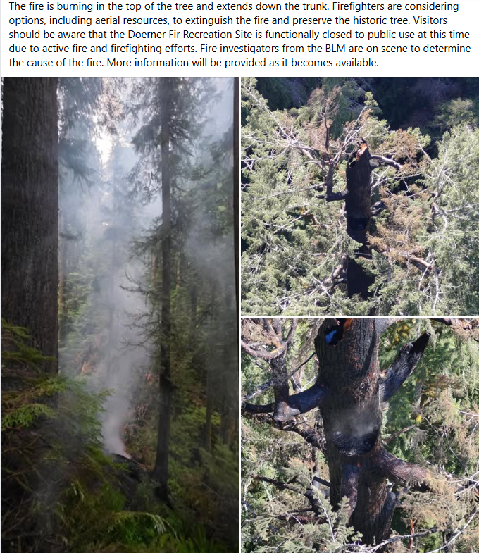
BLM investigators have ruled out lightning as a cause of the fire based on weather data, and the investigation into the cause of the fire continues.The Doerner Fir Tree Fire was first reported on Saturday, Aug. 16, 2025. Standing 325 feet tall with a diameter of 11.5 feet, the Doerner Fir is one of the largest coastal Douglas-fir trees in the world.
The fire is burning in the top of the tree and extends down the trunk. Officials say the tree stands over 325 feet high and has an 11.5-foot diameter. “Formerly known as the Brummit Fir, the tree is one of the tallest non-redwood trees in the world and is estimated to be 450-500 years old,” Coos FPA says.
. Visitors should be aware that the area will be closed to public use at this time due to active fire and firefighting efforts. More information will be provided as it becomes available.
Support Oregon Wildfire Relief with BottleDrop
Donate through BottleDrop to support nonprofits providing wildfire relief for those impacted by recent, ongoing, and future wildfires in Oregon. We’ll match all donations made via BottleDrop through Oct. 7 (up to $20k!) and then split the total donations between the Red Cross Cascades Region, United Way of the Columbia Gorge, and the Oregon Chapter of the WFF.
You can donate in-person by bringing your redeemable beverage containers into any full-service BottleDrop Redemption Center or donate online with funds from your Green Bag account: https://bottledrop.com/…/obrc-emergency-fund-online…/ Learn more: BottleDrop.com/Wildfire
Oregon taxpayers encouraged to participate in survey that could determine future of direct e-filing option
—The Oregon Department of Revenue is encouraging Oregon taxpayers to participate in an anonymous IRS feedback survey on tax preparation and filing options, which will run through September 2, 2025.
Oregon is one of 25 states that partnered with the IRS to provide a free option for taxpayers to file tax year 2024 returns electronically directly with the IRS and the state. More than 13,000 taxpayers filed their 2024 Oregon state income tax returns with Direct File Oregon, including almost 4,700 who first filed their federal returns with IRS Direct File.
“It’s important for Oregon taxpayers to take this opportunity to provide their valuable feedback to the IRS on free tax filing options,” said Oregon Department of Revenue director David Gerstenfeld. “Oregon counts on us to create a clear and easy experience for our customers and free tax filing options help us meet that mission.”
The Oregon Department of Revenue, the U.S. Department of the Treasury and the IRS encourage taxpayers to share their perspectives and help inform this important congressional report.
To participate, visit the Free Online Tax Preparation Feedback Survey or the IRS.gov landing page. Participation is anonymous.
Legislators are scheduled to reconvene in Salem on August 29 to deliberate on initiative aimed at increasing the gas tax and payroll tax to finance Oregon’s infrastructure and avert layoffs at ODOT.
The proposal seeks to raise the state gas tax by six cents, bringing it to a total of 46 cents per gallon, in addition to increasing title and registration fees. Furthermore, it plans to gradually implement a road usage charge for electric and hybrid vehicles beginning in 2027. There will also be a slight increase in the payroll tax designated for transit.
Notably, the plan intends to abolish mandatory tolling on significant state highways, with a public hearing scheduled for August 25 at the Capitol.
Several lawmakers from Oregon convened with state officials and health care providers in Eugene last week to discuss growing health care issues throughout the state.
U.S. Senators Ron Wyden and Jeff Merkley, along with U.S. Representative Val Hoyle, participated in discussions regarding the implications of President Trump’s “big, beautiful bill” for the residents of Oregon. Health care emerged as a significant topic, with Merkley labeling the bill a betrayal, asserting that it will favor the wealthiest Americans while imposing additional burdens on the less affluent.
Merkley indicated that in Oregon, the financial repercussions, encompassing both rising costs and reduced revenue, amount to an estimated $12 million reduction over a span of six years. During the forum, community leaders and health care providers had the opportunity to pose questions and express their concerns. No new plan was announced.
The Oregon State Fair runs thru September 1st. This year, there will be a total of 11 concerts. Featured artists include the All American Rejects, Wynonna Judd, Cheap Trick, and the Beach Boys.
Attendance to the concerts is complimentary with general admission to the fair; however, reserved seating and VIP Plus Suite Seats can be purchased. Tickets are available for purchase on the Oregon State Fair’s official website. The fair will take place from August 22nd until September 1st. Buy tickets and learn more at: https://oregonstatefair.org/
Oregon Attorney General Dan Rayfield is collaborating with 21 other states to file a lawsuit against the Trump administration regarding the withholding of federal funds designated for crime victim services.
This legal action contests the newly imposed conditions that link Victims of Crime Act grants to state compliance with federal immigration enforcement, a stipulation that is prohibited by Oregon’s sanctuary law. Advocates caution that the potential loss of 15 million dollars in funding for the upcoming year could lead to the closure of shelters and resource centers throughout the state.
State officials contend that the administration is exceeding its authority by imposing political conditions on funds that were never authorized by Congress.
Or, maybe it’s just Trump Derangement Syndrome over and over from Oregon officials.
A man from Coos Bay entered a guilty plea regarding the drunk driving incident that resulted in the death of a cherished softball coach and a promising young student-athlete from Umpqua Community College in April.
Jonathan J. Dowdy pleaded guilty to two counts of second-degree manslaughter for the fatalities of coach Jami Strinz, aged 46, and 19-year-old student Kiley Jones, as stated in court documents submitted to the Coos County Circuit Court.
Additionally, Dowdy admitted guilt to three counts of third-degree assault, five counts of fourth-degree assault, as well as charges of driving with a suspended license and driving under the influence of intoxicants (DUII).
Witnesses who were driving behind Dowdy’s pickup truck observed him swerving dangerously and almost hitting a concrete barrier before he crossed into oncoming traffic on Oregon 42, colliding head-on with the team bus around 10 p.m. on April 18, according to court documents.
One witness had been tailing Dowdy for several miles and had already contacted the police, as noted in a court memo authored by Coos County prosecutor John Blanc in May. First responders discovered both empty and unopened beer cans scattered along the four-lane state highway, and Dowdy’s blood-alcohol level was subsequently recorded at .22%, as mentioned in Blanc’s memo.
The community college team was returning home after a victory on Friday night when the bus overturned during the crash, resulting in injuries to all passengers and the deaths of the player and coach.
Keep Oregon Green Association – Statewide Billboard Poster Contest

Keep Oregon Green is turning 85 next year. To celebrate, the Association is asking Oregonians of all ages to create and submit artwork for a statewide billboard poster contest. Learn more about it here: https://keeporegongreen.org/kog-billboard-contest/
SOME PARKS TO SEE UPDATES TO PARKING FEES AND SEASONAL CAMPING RATES
SALEM, Oregon— Oregon Parks and Recreation Department (OPRD) is updating some visitor fees at select parks as part of a broader, proactive effort to build a more resilient financial future for Oregon State Parks.
Starting Oct. 1, 2025, Oregon State Parks will no longer waive the parking fee at 21 additional day-use parks. The parking fee is currently $10 for in-state visitors and $12 out-of-state visitors.
The parking fee does not apply to visitors who walk, bike, use public transportation, have a valid hangtag from camping at an Oregon State Park or a 12 or 24-month parking permit. Currently, OPRD charges for parking at 25 parks and waives parking fees at over 225 parks across the state.
The 21 additional parks include some of the busiest parks in the system such as Harris Beach State Park, which experienced an estimated 2 million day-use visits last year. Visitor fees help pay for maintenance and operation.
Some overnight camping rates will also see updates for visits beginning May 1, 2026:
- Overnight rates at our 29 busiest parks will increase to the top of the current rate range from May 1 through September 30. This increase will apply year round on Friday, Saturday and Sunday nights (Top rate is $29 for tents and $52 for full hook-up RV)
- At all parks:
- Cabin and yurt prices will increase to the top of the rate range year round. (Top rates vary from $72 for rustic yurts to $129 for deluxe cabins/yurts)
- Boat moorage fees will increase from $15 to $20.
- Overnight parking, overflow camping and primitive camping fees will increase from about $10 to at least $15 per night.
The park system faces a projected 14% budget shortfall due to increasing costs, impacts from record visitation and a reduction in lottery funds for operations. These targeted fee adjustments, along with internal efforts to reduce costs, modernize procurement and explore new revenue, will help maintain current service levels and ensure the system remains strong and accessible now and in the future.
“State parks are some of the most beloved spaces in Oregon, but we have struggled as a state to sustainably fund them. We’re working to reimagine the future of Oregon State Parks as financially resilient system that will serve generations to come,” said Director Lisa Sumption.
State parks has three main sources of funding: a little less than half comes from constitutionally dedicated lottery funds, about 15% comes from recreational vehicle license plate fees and roughly 35% comes from park fees from visitors. It is not funded by general fund taxes.
For visitors looking to save on parking, there are annual and 24-month parking permits available for Oregon State Parks. The 12-month parking permit costs $30 and the 24-month permit costs $50. You can buy them online.
Oregon State Parks is also collecting feedback to help guide its effort to reimagine a stronger resilient park system. The surveyincludes priorities for new and existing experiences, services and amenities as well as views on public-private partnerships, sponsorships and other funding options.
New survey gathers feedback to help build a more sustainable future for parks
— Oregon Parks and Recreation Department (OPRD) wants to better understand the public’s values and priorities for the future of state parks through a new survey as it launches a strategic initiative to reimagine how parks are funded, operated and supported.
OPRD faces a potential 14% budget shortfall for park operations by 2027 even with recent fee increases. The gap is due to increasing costs, the impact of higher visitation and changes in lottery funds. The strategic initiative will work to address that shortfall before 2027.

“For more than a century, Oregon’s parks have been a source of pride, joy, and connection for communities across the state,” said Lisa Sumption, OPRD Director. “But the way we fund the system has not kept up with how Oregonians use and value it today. We’re not waiting for the crisis—we’re planning ahead to build a more resilient and relevant park system.”
OPRD launched an online survey this month to collect feedback from visitors and potential visitors about their priorities for new and existing experiences, services and amenities as well as views on public-private partnerships, sponsorships and other funding options.
The survey is open to everyone and will help inform decisions about the future of state parks. Those who complete the survey have the option of entering a drawing for a free Oregon State Parks annual parking permit.
Oregon State Parks continues to experience record visitation with more than 56.6 million estimated visits in 2024. It is one of the most visited park systems in the country.
This level of use significantly increases wear and tear on aging park infrastructure, driving up maintenance needs and long-term operational costs.
Parks’ funding comes from three main sources. A little less than half comes from constitutionally dedicated lottery funds, about 15% comes from the agency’s share of recreational vehicle license plate fees and roughly 35% comes from park fees from visitors. Oregon State Park operations is not funded by general fund taxes.
“We already operate leanly, but we’re also taking a hard look at costs and spending decisions as we plan the future. We’re building new partnerships with Oregon businesses and growing opportunities for visitors to experience state parks in new and innovative ways,” Sumption said.
In addition to operating more than 250 state parks and maintaining hundreds of historic structures, the agency also manages the ocean shore, the State Historic Preservation Office, ATV safety programs and permits as well as multiple grant programs for trails, ATVs, historic structures and local government projects.
For more information about the survey or to learn about ways to support parks, visit stateparks.oregon.gov/ or take the survey at bit.ly/stateparksurvey.
Registration Now Open for 2025 Oregon Women Veterans Conference
Registration is now open for the 2025 Oregon Women Veterans Conference, the state’s largest gathering dedicated to honoring and supporting women who have served in the U.S. Armed Forces. The biennial event, hosted by the Oregon Department of Veterans’ Affairs, will bring together women veterans from across Oregon for a weekend of connection, resources and recognition.

The event is free and open to all women veterans, but registration is required. The 2025 Oregon Women Veterans Conference is being held on Saturday, September 27, 2025, at the Riverhouse Lodge in Bend, which was the planned location of the 2020 event that was canceled due to the COVID-19 pandemic.
“This year’s theme, ‘Stronger Together: Community and Connection,’ reflects the heart of what this conference is all about,” said Dr. Nakeia Council Daniels, director of the Oregon Department of Veterans’ Affairs. “Women veterans have long served with distinction, strength and resilience — often in the face of tremendous challenges and barriers.
“This conference is an opportunity to honor our service, share our stories, and ensure every woman who has worn the uniform feels seen, valued and supported. We are stronger when we stand together, and united, we will continue to drive the ODVA mission forward.”
The Oregon Women Veterans Conference began nearly 30 years ago as a grassroots effort by a small group of women veterans seeking connection, support, and resources. Since the first event in 1998, the conference has grown into a unique statewide gathering that brings together women veterans from across Oregon to access benefits, build meaningful connections, and amplify their voices.
The 2025 conference will continue that legacy with inspiring keynote speakers, engaging workshops, fantastic networking opportunities and assistance for women veterans connecting to the full range of benefits and resources they have earned. It is a supportive space where women who have served can connect, grow, and thrive beyond their military service.
This year’s keynote speaker is Erin McMahon, director of the Oregon Department of Emergency Management and a retired U.S. Army brigadier general, attorney and combat veteran. During her 24-year career in the U.S. Army, McMahon served as the principal deputy general counsel for the National Guard Bureau, advising senior leaders through a wide variety of domestic disaster responses and serving as the first female Army National Guard general officer in the Office of the General Counsel.
Registration is free and may be completed online at www.eventbrite.com/e/odva-women-veterans-conference-tickets-1407725487829. Community sponsors and donors are the primary sources of funding for this event and help ensure all women veterans can attend the conference free of charge.
Registration for the Women Veterans Conference covers the event only; attendees are expected to make their own lodging and travel arrangements. More information about the Women Veterans Conference, including local lodging, donations and sponsorship opportunities, can be found online at wvc.oregondva.com.
Established in 1945, the Oregon Department of Veterans’ Affairs is dedicated to serving Oregon’s diverse veteran community that spans five eras of service members. ODVA administers programs and provides special advocacy and assistance in accessing earned veteran benefits across the state. Learn about veteran benefits and services, or locate a local county or tribal veteran service office online at oregon.gov/odva.
Oregon Department of Veterans’ Affairs
No veteran should be without a place to call home, and the Oregon Department of Veterans’ Affairs is committed to ending veteran homelessness in our state.
The new ODVA Houseless Veterans Program collaborates with federal, state, county, and Tribal agencies, veteran services offices, and community homeless service providers to meet the urgent and unique needs of Oregon’s diverse veteran communities challenged with housing stability.
In addition to advocating for Oregon veterans experiencing or at risk for houselessness, the program provides direct service to veterans and their families seeking federal and state veterans’ benefits, including access to local VA health care, documentation of service, as well as other available state benefits, and local homeless services organizations and low-income assistance programs.
If you or a veteran you know is dealing with homelessness, contact the ODVA Houseless Veterans Coordinator today at houselessvets@odva.oregon.gov or visit https://ow.ly/V4EH50VnL93 to learn more.
August is National Emergency Management Awareness Month in Oregon

SALEM, Ore. – Governor Tina Kotek has officially proclaimed August 2025 as National Emergency Management Awareness Month in Oregon, recognizing the vital work of emergency managers and the role they play in helping communities prepare for, respond to and recover from disasters.
The proclamation supports a national campaign spearheaded by the International Association of Emergency Managers to increase public awareness and appreciation for the emergency management profession.
In Oregon, the campaign is being led by the Oregon Department of Emergency Management (OEM), in partnership with local, Tribal, regional, and state emergency management agencies.
“Emergency management is often invisible until something goes wrong—then it becomes essential,” said OEM Director Erin McMahon. “We’re proud to spotlight the field of emergency management and the dedicated professionals who work every day to protect lives, strengthen community resilience, and coordinate help when it’s needed most.”
OEM’s Role in Supporting Emergency Management Statewide
OEM plays a key leadership role in supporting and strengthening emergency management across the state. Through its Regional Emergency Management Coordinators Program, OEM employs specialized field staff to support all 36 counties and Oregon’s nine federally recognized Tribes. These coordinators provide on-the-ground guidance and technical assistance across all phases of emergency management—from preparedness to long-term recovery.
Additionally, OEM’s Tribal Liaison works closely with Tribal Nations to coordinate emergency management initiatives and ensure Tribal needs are represented in state planning and response efforts. The OEM Public Private Partnership Program Manager coordinates and collaborates with business and industry stakeholders across emergency preparedness, response, and recovery operations, serving as a liaison between the private sector and local and state agencies. This collaboration is further reinforced by the Private Sector Security and Resilience Seminar Series; a recurring program of educational sessions designed to inform and engage private sector participants and better equip them to navigate crises effectively and recover swiftly.
OEM also manages the State Emergency Coordination Center (ECC), which is activated during large-scale or multi-jurisdictional emergencies. The ECC serves as a central hub for coordination and communication among state agencies and emergency support partners, ensuring that local needs are met efficiently and effectively.
With responsibility for coordinating Oregon’s 18 Emergency Support Functions and supporting more than 50 local and Tribal emergency management offices, OEM is dedicated to building a resilient and well-coordinated emergency services system.
How to Celebrate Emergency Management Awareness Month
There are many simple ways Oregonians can show support for emergency managers and become more prepared:
- Find out who your local emergency manager is—reach out to learn how your community prepares for disasters.
- Say thank you to your emergency management staff, volunteers, or CERT team members.
- Get prepared: Make or update your emergency kit, sign up for local alerts at ORAlert.gov, review your household emergency plan, and take the next step by becoming Be 2 Weeks Ready.
- Share your story: Use social media to highlight how you or your community prepares and tag #EMAwarenessMonth.
Follow OEM throughout August for resources to help celebrate and share the value of emergency management.
### It is the mission of the Oregon Department of Emergency Management (OEM) to lead collaborative statewide efforts, inclusive of all partners and the communities we serve, to ensure the capability to get help in an emergency and to protect, mitigate, prepare for, respond to, and recover from emergencies or disasters regardless of cause. OEM prioritizes an equitable and inclusive culture of preparedness that empowers all Oregonians to thrive in times in crisis. The agency leads collaborative statewide efforts, inclusive of all partners and the communities we serve, to ensure the capability to get help in an emergency and to protect, mitigate, prepare for, respond to, and recover from emergencies or disasters. For more information about the OEM, visit oregon.gov/oem. You can get this document in other languages, large print, braille, or a format you prefer. For assistance, email OEM_PublicInfo@oem.oregon.gov. We accept all relay calls, or you can dial 711.
Staying Informed During a Communications Outage: Best Practices for the Public
Disasters can damage critical infrastructure, leading to temporary outages in cell service, internet, and power. When communication systems go down, it’s vital to be prepared with alternate ways to get emergency information and stay connected. Here’s how you can prepare and respond:
Have a Battery-Powered or Hand-Crank Emergency Weather Radio
- Why it matters: Emergency radios can receive Emergency Alert System (EAS) broadcasts via AM/FM or NOAA Weather Radio frequencies—even when cell towers and the internet are down.
- Note: Emergency radios do not receive Wireless Emergency Alerts (WEA) like cell phones do. Tip: Pre-tune your radio to your local emergency broadcast station (e.g., OPB in Oregon or NOAA frequencies).
Turn On WEA Alerts on Your Phone
- Make sure Wireless Emergency Alerts (WEA) are enabled in your phone’s settings. These alerts include evacuation orders, severe weather warnings, and other urgent notifications.
- WEA messages are sent through cell towers—if cell service is out, WEA alerts will not be delivered. This is why having backup methods like a radio is essential.
Charge Everything in Advance and Have Backup Power
- Charge phones, power banks, laptops, and rechargeable flashlights before fire weather conditions worsen.
- Consider solar-powered chargers or car chargers as backups.
- If you are sheltering in place, a generator (solar or gas powered) is helpful.
Know Your Evacuation Routes in Advance
- Save printed or downloaded evacuation maps in case you can’t access GPS or navigation apps.
- Most mapping services (like Google Maps or Apple Maps) offer the ability to “Make maps available offline.” Download your area in advance so you can navigate even if cell towers or internet access are down.
- When in doubt, call 511 or visit the TripCheck.com website if you have cell service.
- Don’t wait for a notification—if you feel unsafe, evacuate early.
Print or Write Down Critical Contacts and Info
- Phone numbers of family, neighbors, and local emergency contacts.
- Address of evacuation shelters, veterinary services (for pets/livestock), and medical facilities.
- Your own emergency plan, including meeting locations.
- Have copies of vital documents in your go-bag and take video of your property (inside and out) for insurance claims later.
If Calling 9-1-1 Over Wi-Fi or Satellite, Check Your Location Settings
If you call 9-1-1 using Wi-Fi calling or a satellite-connected phone (like an iPhone or Android), your location might not be automatically visible to dispatch. Instead, it may rely on the emergency address saved in your phone’s settings.
- Update this emergency address when you travel or relocate—especially in evacuation zones or rural areas.
- Most importantly, always tell the dispatcher exactly where you are—include your address, landmarks, road names, or mile markers to help first responders reach you quickly.
Sign Up for Alerts Before There’s an Outage
- Register for OR-Alert and your county’s local alert system.
- Follow your local emergency management officials’ and bookmark resources like: wildfire.oregon.gov.
Prepare for Alert Delays or Gaps
- Know the three levels of evacuation:
- Level 1 – Be Ready
- Level 2 – Be Set
- Level 3 – GO NOW
- If you hear a siren, see a neighbor evacuating, or witness fire behavior increasing—take action even if you haven’t received an alert.
Be Your Own Info Network
- Check on neighbors, especially seniors or those with disabilities.
- Post printed signs with updates for those passing by.
In rural areas, community bulletin boards or fire stations may serve as local information points.
Support and Restoration in Progress
To help maintain emergency communications during this incident, OEM deployed eight Starlink terminals under the guidance of ESF 2 and the Statewide Interoperability Coordinator (SWIC). A Communications Technician (Jeff Perkins) was also deployed to assess connectivity needs on the ground. These Starlink terminals have been providing service to the Lake County Emergency Operations Center (EOC), Oregon State Police (OSP), Warner Creek Correctional Facility, and will soon support the town of Lakeview, the Bureau of Land Management (BLM), and the Lakeview Ranger Station. OEM’s Regional Coordinator (Stacey) is also on-site supporting the Lake County EOC. Coordination has been strong across local, state, and private sector partners. *** Update: As of 7/10/25 at 1:47 PM, fiber service has been restored.
Reconnect When Service Returns
- Once communications are restored, check official websites:
- Oregon.gov/oem
- Your county emergency management page
- TripCheck.com for road conditions
- Share verified info—not rumors—on social media or community pages.
Prepare for Delays in Restoration
- Communication may come back in phases. Damage to fiber lines or cell towers can take time to repair.
- Continue using backup methods and stay alert for updates via radio or in-person notices.
Final Tip:
In an emergency, CALL 9-1-1 to report life-threatening danger, not for general information. Use local non-emergency numbers or go to physical information points if needed. You can find more tips for preparing in OEM’s Be2Weeks Ready toolkit.

Oregon’s Missing Persons
Many times you’ll see postings without case numbers or police contact. There is rarely a nefarious reason why (the nefarious ones are pretty obvious). Usually the loved one tried to call to report their missing person and they are either refused or told to wait a day or two by people who are unaware of SB 351 and the laws that they are bound to when answering the phone. Many people don’t bother calling LE if their loved one is homeless or in transition because they believe LE won’t care. The biggest myth is the 24 hour rule.
https://www.oregon.gov/osp/missing/pages/missingpersons.aspx

https://www.facebook.com/groups/1109674113319848

 Oregon State Police are reminding parents and students of the SafeOregon hotline.
It takes reports of potential threats against students and schools. The tips can be made anonymously. They can include safety threats, fights, drugs, weapons on campus, cyberbullying and students considering self-harm or suicide. A technician reviews the reports and assigns them either to police or school administrators. Tips can be made by phone, text, email or on the website https://www.safeoregon.com

Call us at 541-363-7503 Or email us at Info@RogueValleyMagazine.com