
The latest news stories of interest in the Rogue Valley and the state of Oregon from the digital home of Southern Oregon, Wynne Broadcasting’s RogueValleyMagazine.com
Monday, July 27, 2026
Rogue Valley Weather

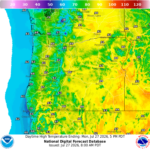
https://graphical.weather.gov/sectors/oregon.php
 https://graphical.weather.gov/sectors/oregon.php
East Evans Creek Fire – Jackson County
The East Evans Creek Fire is now 66% contained following another day of mop-up operations across the incident. Acreage remains 15,580.

Mop-Up Progress: Crews completed 300 feet of deep mop-up work adjacent to the primary fire line. This effort systematically cools hot spots and prevents interior embers from crossing containment boundaries.
]Resource Optimization: Operational command transitioned to a Florida Complex Incident Management Team as of July 27, 2026. Crews have begun demobilizing and packing up equipment that is no longer needed on the line.
Active Evacuations: All emergency evacuation levels remain downgraded to a Level 1 “Be Ready” notice for zones JAC-016, JAC-017, JAC-026, JAC-109, JAC-124, JAC-126, JAC-147, JAC-148, JAC-149, JAC-158, and JAC-203-B.
Safety Closures: Roadblocks remain active for public safety. Traffic remains closed to the general public on East Evans Creek Road at Meadows Road, along with Bureau of Land Management restrictions on West Fork Evans Creek Road and Rock Creek Road.
Incident History: The blaze originally ignited on July 10, 2026, following a vehicle crash into a roadside utility pole.
Wildfire Update – 07.26.26 11:30 AM Fire crews from Siskiyou Mountains Ranger District performed a grid of the Clay Fire (#203) near Windemar Drive in the Ashland Watershed this morning and extinguished all remaining areas of heat.
On July 26, 2026, at 01:32:18, the Illinois Valley Fire District and ODF Southwest Oregon District responded to a reported grass fire at 55xx Caves Highway, Cave Junction.

𝐆𝐫𝐚𝐬𝐬 𝐅𝐢𝐫𝐞, 𝐉𝐮𝐥𝐲 𝟐𝟔, 𝟐𝟎𝟐𝟔 | 𝟐:𝟎𝟓 𝐏𝐌

(SHAN CREEK) — A detached garage was destroyed by fire today at a residence near Griffin Park.

7/25/26, 06:48 hrs. (COLONIAL VALLEY) — A fire that originated inside a pump shed also involved a wood pile and approximately 1/10th acre of vegetation.
Firefighters with Rural Metro Fire, Grants Pass Fire and ODF Southwest Oregon District converged on the scene on Granite Hill Road near Winona Road, and completed full extinguishment and mop-up operations.
Josephine County Fair Starts Wednesday!

 IT’S FAIR WEEK!
  And have you seen the forecast?
 FREE LIVE MUSIC EVERY DAY AT THE FAIR!
 FREE Fair admission every day! (Grandstand events and rodeo tickets sold separately.)
A June 2026 report by the Woodlands Grove Recovery Campus shows that Roseburg, Eugene-Springfield, and Medford rank among the top five U.S. cities for alcohol-induced deaths in adults aged 65 and older. Six Oregon metro areas appear in the top 15 nationwide based on data from 2020 to 2024.
Oregon communities have some of the nation’s highest rates of alcohol-related deaths among adults age 65 and older. That’s according to a new study conducted by the Woodlands Grove Recovery Campus in Ohio. It used CDC data from 2020 through 2024 to rank metro areas by both alcohol-induced death rates and total number of deaths.
City Rankings and Death Rates
- Roseburg: Ranks 2nd nationally with 342.9 deaths per 100,000 older adults.
- Eugene-Springfield: Ranks 4th nationally with 275.7 deaths per 100,000 older adults.
- Medford: Ranks 5th nationally with 248.7 deaths per 100,000 older adults.
- Salem: Ranks 9th nationally.
- Bend: Ranks 11th nationally.
- Portland metro area: Ranks 15th nationally.
Contributing Factors
- Aging Population: A growing number of older residents increases vulnerable demographics.
- Health Care Gaps: Rural areas face severe shortages in treatment options and medical care.
- Local Culture and Policy: Low state alcohol taxes and a strong local drinking culture contribute to the high rates. Overall, Oregon’s alcohol-induced death rate sits 83% higher than the U.S. average.
If you or someone you know needs support, you can reach the free and confidential Oregon Alcohol and Drug Helpline at 800-923-4357, available 24/7/365.
Investigators Serve Ashland Search Warrant After Unidentified Suspect Sent Thousands of Child Sexual Abuse Material Images to Undercover Agent
ODOJ Case CJD0550-26 ASHLAND, Ore. – The Southern Oregon Child Exploitation Team (SOCET) along with the Oregon Department of Justice’s (ODOJ) Internet Crimes Against Children (ICAC) Task Force and Ashland Police Department (APD) served a search warrant Wednesday morning in Ashland.
The task force served the search warrant after SOCET investigators received over 2000 images of Child Sexual Abuse Material (CSAM) images directly from an unidentified suspect.

On scene, investigators interviewed potential witnesses and involved parties. SOCET investigators are working to identify the suspect. Once identified, investigators will refer criminal charges to the Jackson County District Attorney’s Office.
SOCET served the search warrant Wednesday, July 22 at an apartment in the 400 block of Russell Street in Ashland. Jackson County Sheriff’s Office (JCSO), Homeland Security Investigations (HSI), Medford Police Department (MPD), APD, Central Point Police Department, Talent Police Department, ODOJ ICAC, and the Southern Oregon High Tech Crimes Task Force (SOHTCTF) assisted with the warrant service. During the warrant, investigators seized digital devices which will be forensically examined by SOHTCTF for further evidence of child exploitation.
SOCET is a joint inter-agency task force that started in June of 2020 to combat child exploitation. The task force consists of investigators from JCSO, MPD, ODOJ ICAC, and HSI, as well as prosecutors from our local, state, and federal law enforcement partners in Jackson County. SOHTCTF is a joint inter-agency task force that consists of investigators from JCSO, HSI, and MPD.
Investigators continue to examine seized devices and interview witnesses as the investigation moves forward. No further details will be released at this time.
Medford Police — Join us for National Night Out! We’ll be in 𝗔𝗹𝗯𝗮 𝗣𝗮𝗿𝗸 (𝟯𝟬𝟭 𝗪 𝗠𝗮𝗶𝗻 𝗦𝘁𝗿𝗲𝗲𝘁) on 𝗔𝘂𝗴𝘂𝘀𝘁 𝟰 from 𝟱-𝟳 𝗽.𝗺.

Rogue River Growers Market Inc
40 Modular Homes to Be Built in Phoenix to Replace Homes Lost in Almeda Fire
Oregon Housing and Community Services selected five projects to build 117 affordable homes using factory-produced housing methods across the state.
AGE+ and Blazer Modular Construction plan to use the funding to build 40 fully accessible, affordable homes for older adults in Phoenix. The project, Phoenix Commons, will replace housing lost in the Almeda Fire. The modular construction will reduce per-unit costs and cut the construction schedule by several months.
The initiative comes from House Bill 3145 passed in the 2025 Legislative Session. It will fund up to five factory-produced housing projects with Local Innovation and Fast Track set-aside funds totaling $25 million. Factory-produced housing, like modular homes, offers an alternative to traditional construction and can produce homes faster and at lower costs.
 ACCESS is proud to announce the NEW location of the Talent Food Pantry at the 𝗧𝗮𝗹𝗲𝗻𝘁 𝗛𝗲𝗮𝗹𝘁𝗵 𝗖𝗲𝗻𝘁𝗲𝗿, located at 49 Talent Ave. in Talent.
City of Roseburg Government — Wondering where to get the facts about City projects, plans, decisions, events and upcoming meetings?
𝗙𝗲𝗮𝘁𝘂𝗿𝗲𝗱 𝗙𝗼𝗼𝗱 𝗣𝗮𝗻𝘁𝗿𝘆: 𝗦𝗮𝗹𝘃𝗮𝘁𝗶𝗼𝗻 𝗔𝗿𝗺𝘆 𝗣𝗮𝗻𝘁𝗿𝘆 


Southern Oregon PBS Still on The Air Despite Federal Funding Loss

Rogue Valley Humane Society
Our Community Food Bank exists to help folks who need an extra helping hand during a difficult month to feed their pets. Our program has a limited budget and so we rely on generous members of our community to donate some of these goods to continue to help assist our community. In 2023 we fed an average of 700 pets a month!
This equates to approximately 70 – 40lb bags of food each month! Many pets have benefited from the community’s generosity, and we can’t thank you enough for your kindness.
CSO Case 24-4928 PROSPECT, Ore. – Jackson County Sheriff’s Office (JCSO) detectives and Search and Rescue (SAR) personnel continue to search for a woman missing out of Prospect, Ore. since September 2024.
Deenah Padgett, 69, was reported missing on Sunday, September 8, 2024. She was last seen camping in the Prospect area on September 4, 2024.
She is described as a white woman with brownish-red, partially gray hair, standing 4’8” tall and weighing 90-100 lbs. JCSO detectives and SAR personnel have searched the area extensively and are looking for the public’s help. If you see Deenah or know her whereabouts, immediately call ECSO Dispatch at (541) 776-7206 and reference case 24-4928.
If you have any information that might help the investigation, call Detective Friend at (541) 864-8774.
The Jackson County Sheriff’s Office (JCSO) is asking for help identifying the owner a motorhome. It could be associated with a missing person from the Prospect area. JCSO says 68-year-old Deenah Padgett has been missing since August 30 from Prospect, described as a white woman, 4’ 8” tall, weighing approximately 95 pounds with brownish red/greying hair. JCSO issued an advisory this weekend asking anyone with information about the owner of the pictured motor home or Padgett’s whereabouts to call Emergency Communications of Southern Oregon (ECSO) dispatch non-emergency phone number at 541-776-7206.
David Grubbs’ Murder Investigation Remains Active
The Ashland Police Department’s investigation into the murder of David Grubbs on November 19, 2011 remains open and active. Recently two new detectives have been assigned to look into new leads that have come in.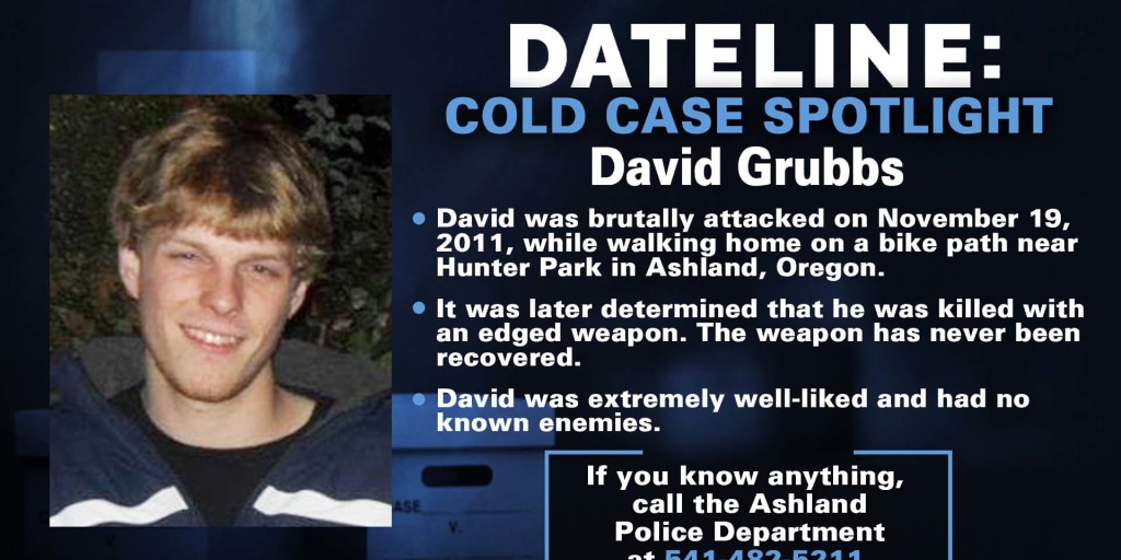 This case remains important to David’s family, the community, and the Ashland Police Department. As detectives continue to pursue these new leads, anyone with additional information is encouraged to reach out to the Ashland Police Department at 541-488-2211. The reward for information leading to an arrest on this case remains at over $21,000.
Taking Another Look at What Happened to Fauna Frey
Fauna was grieving the recent death of her brother, Dallas, when she set off from Eugene in June of 2020 heading to Grants Pass on what her family believes was both a healing trip and a mission to deliver gifts, silver coins inherited from Dallas, to a few friends. But somewhere between motel check-ins and checkouts, something went terribly wrong. Her Jeep was found months later. She was never seen again. http://bit.ly/4l63Dle

We will start resharing podcasts and articles. For starters here is a story from Danielle Denham that appeared in the June 29, 2025 edition of That Oregon Life. Ms Denham worked closely with us to insure that the facts she presented were accurate. Check out the nine episodes of the podcast Nowhere to be Found, a comprehensive, in-depth, sensitive treatment of the details surrounding Fauna’s disappearance. Hear from Fauna’s father, John, and her friends. Posted in spring of 2022, Amanda Popineau shares Fauna’s journey and the mystery that surrounds it. Go to Nowhere to be Found Season Two: Episode One “Under A Half-Moon.”
https://podcasts.apple.com/kg/podcast/s2e1-under-a-halfmoon/id1532686678?i=1000512098162
We want to remind people that Fauna’s father is offering a huge reward for information that brings Fauna home. Please if you have any information no matter how big or small let us know by calling the anonymous tip line or emailing. Tipline- 541-359-5638 Email – Helpfindfaunafrey@gmail.com FOLLOW on FACEBOOK GROUP: https://www.facebook.com/groups/341658526970132
Fauna Frey Vanished Without A Trace In Josephine County
 It’s been more than five years since the disappearance of a Lane County Woman, who was last seen in Grants Pass. Back in June of 2020, Fauna Frey disappeared. Police said the 45-year-old left her home in Dexter to drive to Grants Pass to visit her brother’s friend after her brother had recently passed away. The last place she was seen was at the Big 5 in Grants Pass. Investigators said her car was found in the Galice area months later. The circumstances of Fauna’s disappearance remain unclear and her case is currently classified as missing. Her case remains unsolved. Fauna’s disappearance has been featured on multiple investigative podcasts, including Nowhere to be Found, Here One Minute, Gone the Next, and Detective Perspective, each trying to fill the silence left by law enforcement. New listeners continue to discover her story, hoping a fresh set of eyes or a single loose memory might be the key to finding Fauna.
Have Information on Fauna Frey? Please Speak Up!
If you know anything, no matter how small, please contact:
- Josephine County Sheriff’s Office
- Tip line: (541) 359-5638
- Email: FindFaunaFrey@gmail.com
Currrently there is a $50,000 CASH REWARD for information leading to the location of Fauna Frey. LARGE CASH REWARDS are being offered for any other relevant information, such as any objects that could be identified as Fauna’s, i.e. her wallet, keys, or Indian/Buffalo .999 silver bullion coins. Find Fauna Frey Facebook Group: https://www.facebook.com/groups/341658526970132
You can find food in your community at this link
Our network of food banks and pantries provides free food and groceries across Oregon. No proof of income or documentation required.
https://www.oregonfoodbank.org/
If you can’t make it to a food location, someone else can pick up food for you.You will just need to print and fill out the Authorized Representative form at https://lnkd.in/dsskUpkQ, and have them take it with them to the food sites. You can find step-by-step instructions at https://lnkd.in/dVBRxn-A.
Worried about recent changes or losing assistance?
Here are resources that can help: 211Info: Dial 2-1-1 or visit the211Info food webpagefor information and referrals to more than 1,500 food resources across Oregon. Oregon Food Bank: Use the Oregon Food Bank’s Food Finder Map to find over 100 food pantries, free food markets or hot meal programs near you. Aging and Disability Resource Connection of Oregon (ADRC): Call 855-673-2372 or visit theADRC food webpage to find local meal programs and food boxes in your area.

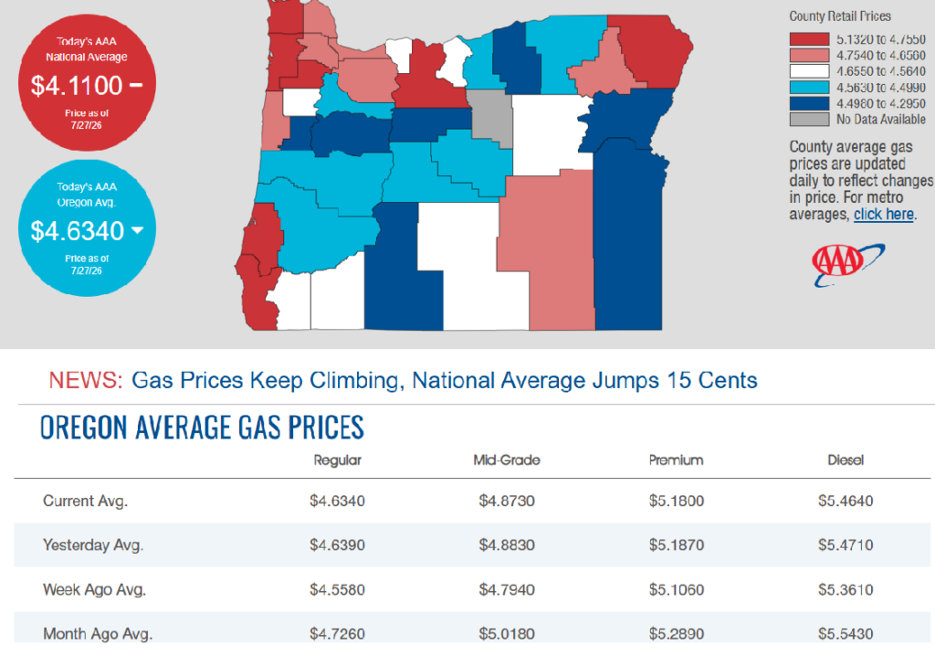
7/27/2026 — Gas Prices in Oregon Today
OSP investigating report of individuals impersonating law enforcement

CLACKAMAS COUNTY, OR– The Oregon State Police and Federal Bureau of Investigation are investigating a report of individuals impersonating law enforcement officers in Clackamas County and are asking for the public’s assistance.
There is already fear and uncertainty among immigrant communities across Oregon. OSP investigators are actively pursuing leads and conducting a thorough investigation to identify those responsible.
On Friday, July 17, 2026, between approximately 3:30 p.m. and 5 p.m., the victim was driving on Highway 211 near milepost 5, east of Woodburn, when they observed a vehicle displaying red and blue emergency-style lights behind them. Believing they were being stopped by law enforcement, the victim pulled over onto a gravel turnout.
Two men exited the suspect vehicle, one of whom was armed with a rifle. The suspects identified themselves as “ICE” and told the victim they were being detained. The victim was forcibly removed from their vehicle, searched, and placed into the back seat of the suspects’ vehicle. A third individual, who remained in the vehicle and was described as acting as a “guard,” assaulted the victim while they were detained.
After approximately 15 to 20 minutes, the suspects released the victim and told them they were free to leave.
The suspects were described as wearing boots, baseball caps, face coverings, and green long-sleeved shirts.They wore tactical vests displaying “POLICE” in white lettering and carried badges marked “Police.” The suspect vehicle was described as a newer model smaller SUV, blue or gray in color, with no visible license plates.
The victim later sought medical treatment for injuries sustained during the incident. While at an area hospital, the victim began receiving text messages from a phone number claiming to represent a law firm offering legal representation related to the incident. The messages originated from phone number 971-502-5548.
OSP investigators have contacted federal law enforcement agencies, who confirmed the individuals involved were not federal officers.
A report of individuals impersonating law enforcement officers while falsely claiming to represent federal immigration authorities may have broad impacts on immigrant communities throughout Oregon.
Anyone who witnessed suspicious activity in the area of Hwy. 211 near South Barlow Road on July 17, or anyone who may have encountered individuals posing as law enforcement officers, is asked to contact the Oregon State Police. Investigators are also interested in hearing from anyone who has received similar communications from the phone number 971-502-5548.
Anyone with information is asked to contact OSP dispatch at 800-442-0776 or OSP (677) from a mobile phone. Please reference case number SP26-237961.
OSP encourages all community members to remain vigilant, seek information from trusted sources, and report suspicious activity or individuals claiming to be law enforcement if something does not seem right. To report suspicious activity or individuals claiming to be law enforcement, contact your local law enforcement agency or call 911 in an emergency situation.
Guidance for Confirming Law Enforcement Identity — Federal agencies operating in Oregon have confirmed that officers conducting official operations must clearly identify themselves as law enforcement. They also reiterated that anyone who falsely represents themselves as a federal immigration officer will face criminal prosecution to the fullest extent of the law. Impersonating law enforcement jeopardizes public safety, creates unnecessary fear and confusion, and undermines trust in legitimate agencies.
If you are unsure whether a traffic stop or law enforcement contact is legitimate, consider the following safety tips:
- If the vehicle stopping you is not a marked unit, the emergency lights should be built in and are usually not a temporary light placed on the vehicle.
- Try to stop in a well-lit area or a location where there are a lot of people present.
- Turn on your emergency flashers, but don’t turn off your car.
- Lock your door.
- Look for a uniform or other official department clothing. If you are unsure, ask the officer to display their department identification and badge. Ask where they work and if you can contact their dispatch center to confirm their identity.
- In Oregon, local, state, and federal law enforcement officers may not wear face coverings except in specific circumstances and must clearly display identification showing the agency they represent.
- OSP also acknowledges that Oregon immigrant or refugee communities may not feel safe to do any of these things and also reminds individuals that they can always call 911 or other non-emergency line to ask for a marked vehicle to respond.
# # # About the Oregon State Police – Oregon State Police (OSP) is a multi-disciplined organization that is charged with protecting the people, wildlife, and natural resources in Oregon. OSP enforces traffic laws on the state’s roadways, investigates and solves crime, conducts postmortem examinations and forensic analysis, and provides background checks, and law enforcement data. The agency regulates gaming and enforces fish, wildlife, and natural resource laws. OSP is comprised of nearly 1,400 staff members – including troopers, investigators, and professional staff – who provide a full range of policing and public safety services to Oregon and other law enforcement agencies throughout Oregon.

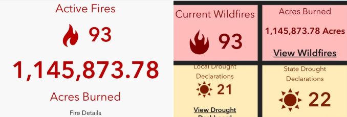
 More than 30 major wildfires burning across central and eastern Oregon with a total of 70 active fires. Majority caused by two lightning events over the span of a couple weeks. Total acreage burned in the state as of today- 1.1 Million acres.
CRITICAL FIRE WEATHER CREATES HIGH FIRE DANGER
Fire Officials Seek Public Cooperation — Critical fire weather conditions, including Red Flag Watches and Warnings, are underway across the Geographic Area, creating an increased risk for rapid wildfire growth. Fire officials urge residents and visitors to help prevent wildfires by avoiding activities that could spark a fire, following local fire restrictions, and staying informed about changing conditions. The public should also monitor evacuation information and be prepared to act quickly if conditions change.
“Right now, everyone needs to be extremely careful,” said Jeff Fedrizzi, Chair of the Pacific Northwest Wildfire Coordinating Group. “Current fire conditions mean that just one spark, a discarded cigarette, or an unattended open flame can ignite the next wildfire. After the lightning we’ve received over the past 10 days and the number of new fires already burning across the landscape, we need the public’s help to prevent additional fires and protect our firefighters, our communities, and our natural resources.”
Fire officials across Oregon and Washington remind residents and visitors that fire restrictions and area closures are in place to reduce the risk of human-caused wildfires during this period of extreme fire danger. Know before you go by checking local fire restrictions and area closures before recreating outdoors. Common activities that can ignite dry vegetation include mowing dry grass, driving off designated roads, operating equipment that creates sparks, and building campfires. Many of these activities are currently prohibited or restricted because of extreme fire conditions. Stay clear of active wildfire areas and firefighting operations. Do not drive to view wildfires, as traffic can delay emergency responders, hinder firefighting efforts, and create additional safety hazards. If you encounter smoke while driving, slow down and use extra caution.
Before traveling or recreating outdoors, check the latest road closures, fire restrictions, fire activity, and evacuation information:
Road Conditions
• Oregon: TripCheck – https://tripcheck.com/
• Washington: WSDOT Real-Time Travel – https://wsdot.com/travel/real-time/
Evacuations & Emergency Alerts
• Oregon: https://oralert.gov/
• Washington: https://mil.wa.gov/alerts
Current Fire Information
• InciWeb: https://inciweb.wildfire.gov/
• Northwest Interagency Coordination Center: https://gacc.nifc.gov/nwcc/
• Air Quality: https://fire.airnow.gov/
Your decisions matter. Stay informed, follow local restrictions and evacuation orders, and help keep yourself, your community, and our firefighters safe.
After a relatively slow start to Oregon’s fire season, prolonged dry conditions with the addition of thunderstorms and strong winds last week have caused the rapid growth of wildfires in several areas of the state.
As of Saturday, a total of roughly 690,197 acres have been burned by wildfires this season.
Govenor Tina Kotek issued a preemptive emergency declaration on June 16, which allows the Oregon fire agencies to share resources. She has since issued emergency conflagration declarations for several fires, allowing for more resources to be mobilized.
The details of all major wildfires currently burning in Oregon are listed below, and information will be continually updated. Wildfires are listed by the county in which they began, but some fires or their evacuation zones extend into neighboring counties.
Fires that reach 90% containment will be removed from the list unless evacuation orders are still in effect, and some smaller fires will be excluded. Information about fire acreage and containment percentages is approximate.
The figures below are up to date as of 8:30 a.m. on Monday, July 27, 2026, unless otherwise noted.
Wheeler County
Note: The Rowe Creek Complex includes the Crosswhite East (181,443 acres), Camel Hump (6,614 acres), Parrish (404 acres) and Deep Canyon (8,089 acres) fires, all of which have physically merged.
Rowe Creek Complex
- Location: Fossil, notably east, north and west of Twickenham, along the John Day River, across Wheeler, Wasco and Crook counties
- Acreage: 208,546acres
- Cause: Lightning
- Began: July 15
- Containment: 35%
- Closures: The Bureau of Land Management closed public lands along both sides of the John Day River, from Service Creek north to the Columbia River; the National Park Service closed the Clarno and Painted Hills sections of John Day Fossil Beds National Monument.
- Evacuations: Level 3, Level 2 and Level 1 evacuations are in place; an interactive map can be found here.
- More info: Visit Wheeler County Sheriff’s Office for more evacuation information, along with their interactive evacuation map. Residents can receive updates and view evacuation zones through Genasys Protect. Check National Park closures and BLM closures at their respective websites.
Shingle Fire
- Location: 14 miles southeast of Mitchell (Wheeler, Grant and Crook counties)
- Acreage: 21,849 acres
- Cause: Lightning
- Began: July 23
- Containment: Unknown
- Closures: None
- Evacuations: Level 2 and 3 evacuations are in place; visit the Wheeler County Sheriff’s Office, Grant County Emergency Management, Crook County Sheriff’s Office or the Shingle Fire Facebook pages for more information.
Gilliam County and Sherman County
Note: The Hoag, Hopkin, McInnes, Porcupine Ridge and Wilcox Fires are now being referred to collectively as the Hay Creek Complex. The fires are burning in Gilliam, Sherman and Wasco counties. (99% contained, as of July 25) As of July 21, the McInnes and Wilcox fires merged into the Porcupine Ridge Fire. (99% contained, as of July 25) A new fire, the Cottonwood Fire, was added to the complex (0% contained) and the Little Buck Fire (0% contained) on July 23.
Hay Creek Complex
- Location: Gilliam, Sherman and Wasco counties
- Acreage: 186,730 acres
- Cause: Multiple
- Began: July 15
- Containment: 60%
- Closures: BLM land is closed near the junction of Interstate 84 and Highway 97, south along Highway 26 and near the junction of highways 27 and 20.
- Evacuations: Some evacuations were made along Scott Canyon Lane, but most of this fire’s growth has not been made toward populated areas. A temporary shelter is in place at the South Gilliam Emergency Services building in Condon.
- More info: Visit the Gilliam County Sheriff’s Office for more details.
Grant County
Salmon Fire
- Location: Southwest of Granite in the North Fork John Day Wilderness
- Acreage: 1,425 acres
- Cause: Lightning
- Began: July 8
- Containment: 60%
- Closures: The Malheur, Umatilla and Wallowa-Whitman National Forests have put temporary forest closures in place around the Salmon, Olive Butte and Anthony fires. A map of closure areas can be seen here.
- Evacuations: Level 3, Level 2 and Level 1 evacuations are in place for areas surrounding the Salmon and Olive Butte fires.
- More info: Visit the Salmon Fire OR 2026 or Baker County Sheriff’s Office Facebook pages for more information. An in-person community meeting will be held at Prairie City High School at 6 p.m. on Thursday. It will also be streamed on the Salmon Fire OR 2026 Facebook page.
Olive Butte Fire
- Location: Southwest of Granite in the North Fork John Day Wilderness
- Acreage: 3,029 acres
- Cause: Lightning
- Began: July 8
- Containment: 60%
- Closures: The Malheur, Umatilla and Wallowa-Whitman National Forests have put temporary forest closures in place around the Salmon, Olive Butte and Anthony fires. A map of closure areas can be seen here.
- Evacuations: Level 3, Level 2 and Level 1 evacuations are in place for areas surrounding the Salmon and Olive Butte fires.
- More info: Visit the Salmon Fire OR 2026 or Baker County Sheriff’s Office Facebook pages for more information.
Anthony Fire
- Location: 34 miles north of Baker City
- Acreage: 2,561 acres
- Cause: Lightning
- Began: July 8
- Containment: 89%
- Closures: The Malheur, Umatilla and Wallowa-Whitman National Forests have put temporary forest closures in place around the Salmon, Olive Butte and Anthony fires. A map of closure areas can be seen here.
- Evacuations: Level 3, Level 2 and Level 1 evacuations are in place for areas surrounding the fire.
- More info: Visit theWallowa-Whitman National Forest or Baker County Sheriff’s Office Facebook pages for more information.
Bologna Fire
- Location: 7 miles northeast of Kimberly
- Acreage: 2,338 acres
- Cause: Lightning
- Began: July 16
- Containment: 15%
- Closures: The Malheur, Umatilla and Wallowa-Whitman National Forests have put temporary forest closures in place around the fire. A map of closure areas can be seen here.
- Evacuations: None
Harney County
Egypt Fire
- Location: 12 miles north of Riley
- Acreage: 4,595 acres
- Cause: Lightning
- Began: July 16
- Containment: 68%
- Closures: None
- Evacuations: None
Baker County
Powder River Fire
- Location: 5 miles west of Richland
- Acreage: 21,026 acres
- Cause: Undetermined
- Began: July 16
- Containment: 52%
- Closures: None
- Evacuations: Level 3 and Level 2 evacuations are in place for areas surrounding the fire. Visit the state RAPTOR map for more information.
- More info: Visit the Baker County Sheriff’s Office Facebook page for more information.
Jackson County
East Evans Creek Fire
- Location: 14 miles northeast of Rogue River
- Acreage: 15,705 acres
- Cause: Vehicle into power pole
- Began: July 10
- Containment: 46%
- Closures: Traffic is closed to the public on East Evans Creek Road at Meadows Road. The BLM has issued a road closure for West Fork Evans Creek Road and Rock Creek Road. Public entry to BLM-administered lands near the fire is also temporarily prohibited.
- Evacuations: Level 1 evacuations are in place in Jackson County. An interactive map of evacuation zones can be found here.
- More info: Visit the East Evans Creek Fire entry on InciWeb for more information.
Jefferson County
Akawa Butte Fire
- Location: Southwest of Lake Billy Chinook in Jefferson and Deschutes counties
- Acreage: 26,435 acres
- Cause: Lightning
- Began: July 16
- Containment: 5%
- Closures: Road closures in place, including Indian Ford Road between Highway 20 and Meadow View Lane, as well as Wilt Road north of Buffalo Drive
- Evacuations: Level 3, 2 and 1 evacuations, including for U.S. Forest Service land, are in place. Interactive map can be seen here.
- More info: Visit the fire’s Facebook page for more details, along with Jefferson County and Deschutes County sheriff’s office Facebook pages. The Deschutes County Sheriff’s Office also has an interactive map of the evacuation zones here. Residents can receive evacuation notices via Everbridge.
Bench Fire
- Location: Four miles southwest ofWarm Springs Reservation
- Acreage: 20,180 acres
- Cause: Unknown
- Began: July 23
- Containment: 0%
- Closures: U.S. 26 is closed near Warm Springs, milepost 108 to 110.
- Evacuations: Level 3, 2 and 1 evacuations are in place; visit the Jefferson County Sheriff’s Office or the CTWS Fire Management Facebook pages for more information. Evacuation zones can be seen on this interactive map.
- More info: Shelters at The Old School Cafeteria at 1150 Warm Springs Street or St. Patrick’s Church at 341 SW J Street in Madras; livestock can be taken to the Jefferson County Fairgrounds at 430 Southwest Fairgrounds Road.
Beachcomb Fire
- Location: Four miles southwest ofWarm Springs Reservation
- Acreage: 13,648 acres
- Cause: Unknown
- Began: July 23
- Containment: 0%
- Closures: U.S. 26 is closed near Warm Springs, milepost 108 to 110.
- Evacuations: Level 3, 2 and 1 evacuations are in place; visit the Jefferson County Sheriff’s Office or the CTWS Fire Management Facebook pages for more information. Evacuation zones can be seen on this interactive map.
- Fire activity: The Beachcomb and Bench fires have merged after burning through dry fuels between the two fires. The increase in acreage reflects extreme fire behavior and recent mapping operations. Fire activity was moderate until winds increased late in the afternoon, leading to more active fire behavior. Heavy aircraft was used throughout the fire area as conditions intensified.
- Operations: Crews continue working on structure protection and strengthening dozer lines as the fire moves farther northeast.
- More info: Shelters at The Old School Cafeteria at 1150 Warm Springs Street or St. Patrick’s Church at 341 SW J
- Street in Madras; livestock can be taken to the Jefferson County Fairgrounds at 430 Southwest Fairgrounds Road.
Brewer Fire
- Location: 1 mile east of Brewer Reservoir in both Crook and Jefferson counties
- Acreage: 51,308 acres
- Cause: Lightning
- Began: July 15
- Containment: 5%
- Closures: None
- Evacuations: Level 3, Level 2 and Level 1 evacuations are in place for the Brewer and Box Springs fires; visit the Crook County Sheriff’s Office Facebook page for updated information.
- More info: Visit the Crook County and Jefferson County sheriff’s offices’ Facebook pages.
Crook County
Coyote Fire
- Location: 25 miles southeast of Prineville
- Acreage: 17,447 acres
- Cause: Undetermined
- Began: July 16
- Containment: 57%
- Closures: None
- Evacuations: Level 3 and Level 1 evacuations are in place; visit the Crook County Sheriff’s Office Facebook page for updated information or view the county’s interactive evacuations map.
- More info: Visit the Crook County Sheriff’s Office Facebook page.
Henry Fire
- Location: 2 miles south of Paulina
- Acreage: 28,827 acres
- Cause: Undetermined
- Began: July 16
- Containment: 35%
- Closures: None
- Evacuations: Level 3 evacuations are in place; visit the Crook County Sheriff’s Office Facebook page for updated information or view the county’s interactive evacuations map.
- More info: Visit the Crook County Sheriff’s Office Facebook page.
Umatilla County
Hagen Fire
- Location: South of Bingham Road
- Acreage: 26,879 acres
- Cause: Lightning
- Began: July 16
- Containment: 0%
- Closures: None
- Evacuations: Level 3, Level 2 and Level 1 evacuations are in place in Umatilla County. Visit the Umatilla County Sheriff’s Office Facebook for current evacuation information, as well as an interactive map here.
- More info: Visit the Umatilla County Sheriff’s Office Facebook.
Wallowa County
Burnt Creek Fire
- Location: 23 miles north of Enterprise
- Acreage: 3,074
- Cause: Lightning
- Began: July 17
- Containment: 0%
- Closures: Chico Trailhead in Wallowa-Whitman National Forest
- Evacuations: None
Wasco County
Grasshopper Fire
- Location: 4 miles northwest of Sportsmans Park and 3.5 miles west of Rock Creek Reservoir
- Acreage: 10,742 Acres
- Cause: Unknown, but lightning suspected
- Began: July 23
- Containment: 0%
- Closures: Several closures are in place for Mount Hood National Forest.
- Evacuations: Level 3 evacuation orders are in place for Sportsman Park, Pine Hollow and Wamic. Shelter will be at Maupin High School, as well as some Level 2 and 1 notices. See the Wasco County Sheriff’s Office Facebook or the U.S. Forest Service for Mount Hood National Forest Facebook for updates, as well as an interactive evacuation map for the county.
- More info: The Sherman County Fairgrounds, located at 66147 Lone Rock Road in Moro, will be available to shelter large animals for evacuees.
Here’s what evacuation levels mean
Level 1 Notice – Be Ready: Residents should be aware of the danger that exists in their area and monitor local media outlets for information. Residents with special needs should take note and begin making arrangements to evacuate. Evacuations at this time are voluntary.
Level 2 Notice – Be Set: This level indicates there is significant danger to your area, and residents should either voluntarily relocate to a shelter or outside of the affected area, or if choosing to remain, to be ready at a moment’s notice. Emergency services cannot guarantee that they will be able to notify you if conditions rapidly deteriorate.
Level 3 Notice – Go Now: Danger to your area is current or imminent, and you should leave immediately. Listen to local media and watch for emergency personnel who may be coming by to give further instructions regarding the evacuation.
Shelters
The Red Cross has opened multiple shelters, including:
- Burns High School at 1100 Oregon Avenue, Burns, OR 97720
- Crook County Fairgrounds (Carey Foster Hall) at 1280 South Main Street, Prineville, OR 97754
- St Patrick Catholic Church at 341 Southwest J Street, Madras, OR
- Sunridge Middle School at 700 Southwest Runnion Avenue, Pendleton, OR 97801
- Sisters High School at 1700 West Mckinney Butte Road, Sisters, OR 97759
Fire Complexes
The following fires have been grouped together as part of larger complexes, and will no longer be individually updated:
Hoag Fire (merged with Starvation Point and Lower Rock Creek fires)
- Location: South of Arlington, near the Rock Creek area
- Acreage: 50,224 acres
- Cause: Unknown
- Began: July 16
- Containment: 99%
- Closures: None
- Evacuations: Level 3, Level 2 and Level 1 evacuations are in place around and between the various fires in the Hay Creek Complex, encompassing an overall area that covers much of the western half of Gilliam County and a large portion of southeast Gilliam County, also extending into Wasco County. See the RAPTOR evacuation map for details on areas under evacuation.
- More info: Visit the Gilliam County Sheriff’s Office or Hay Creek Complex 2026 pages on Facebook for more details.
Hopkin Fire
- Location: North of Condon
- Acreage: 11,366 acres
- Cause: Unknown
- Began: July 15
- Containment: 99%
- Closures: Travel restrictions may be in place along Highway 19 near Gwendolen.
- Evacuations: Level 3, Level 2 and Level 1 evacuations are in place around and between the various fires in the Hay Creek Complex, encompassing an overall area that covers much of the western half of Gilliam County and a large portion of southeast Gilliam County, also extending into Wasco County. See the RAPTOR evacuation map for details on areas under evacuation.
- More info: Visit the Gilliam County Sheriff’s Office or Hay Creek Complex 2026 pages on Facebook for more details.
Porcupine Ridge Fire (merged with the McInnes, 456 and Wilcox fires)
- Location: 7 miles southwest of Condon
- Acreage: 80,081 acres
- Cause: Unknown, but likely lightning
- Began: July 15
- Containment: 99%
- Closures: None
- Evacuations: Level 3, Level 2 and Level 1 evacuations are in place around and between the various fires in the Hay Creek Complex, encompassing an overall area that covers much of the western half of Gilliam County and a large portion of southeast Gilliam County, also extending into Wasco County. See the RAPTOR evacuation map for details on areas under evacuation.
- More info: A temporary shelter for those affected is at the South Gilliam Emergency Services Building, located at 220 Northeast Main Street in Condon. Visit the Gilliam County Sheriff’s Office or Hay Creek Complex 2026 pages on Facebook for more details.
L. L. Stub Stewart and Rooster Rock State Parks will host OMSI Star Parties this summer

— L.L. Stub Stewart and Rooster Rock State Parks will celebrate the night sky with free stargazing parties in July, August and September.
The parks are partnering with OMSI and Rose City Astronomers to host an OMSI Star Party 2026, which includes a presentation at dusk and stargazing from 9 to 11 p.m. Telescopes will be provided by volunteers, and visitors are welcome to bring their own. Depending on the weather, stargazers will search out stars, the moon, and planets.
“We love helping people experience the park in a different way. After dark, everything feels calmer, quieter, and a little more magical,” shared Park Ranger Jeremy Williams at L. L. Stub Stewart State Park.
These events are free. Parking in the day-use areas requires a $10 parking permit per vehicle or you can use an annual parking pass if you have one.
Visitors are encouraged to bring their own chairs, blankets, warm clothing, snacks and water. Bug repellent is always a good idea. Please use red flashlights to avoid interfering with the dark sky viewing. You can also cover your flashlight or smartphone with red electrical tape.
Star maps will be provided along with recommended astronomy apps that visitors can load on their phones if interested.
Visitors should arrive early to familiarize themselves with the area and park only in designated spaces. Overnight camping is not permitted in day-use areas, though campground reservations are available at stateparks.oregon.gov.
On the scheduled day for OMSI Star Parties, visitors should visit the OMSI website for possible weather-related cancellations. The long-range forecast looks promising for excellent viewing.
“Whether you come to Rooster Rock to count Perseids or simply to spend a peaceful evening under the stars, the meteor shower is a wonderful excuse to slow down, look up, and experience the Gorge in a whole new light”, said Park Ranger Elika Paki at Rooster Rock. “And if you lose track of how many shooting stars you’ve seen, don’t worry, that just means you’re doing it right.”
All events begin at dusk. We recommend arriving early to accommodate parking. Parks will close at 11:45 p.m.
Perseid Meteor Shower Watch | Wednesday, August 12
- L. L. Stub Stewart State Park
- Rooster Rock State Park
Equinox Celebration | Saturday, September 12
- L. L. Stub Stewart State Park
You can find additional details about the event, parking logistics, whether pets are allowed, and how to request accessibility accommodations on the L.L. Stub Stewart State Park and Rooster Rock State Park event pages, and the OMSI event page.
Oregon State Parks often hosts stargazing events across the state. More opportunities can be found on Oregon State Parks’ event page.
Public invited to comment on plan to possibly triple logging in eastern Oregon national forests
The U.S. Forest Service’s proposed revisions to the Blue Mountain Forest Plan would allow more logging and taking older trees in the name of wildfire prevention

Officials at the U.S. Forest Service are proposing new management plans for eastern Oregon’s Blue Mountains that include potentially tripling the amount of logging across 5.5 million acres in the next decade.
The Forest Service published a draft of proposed changes to the 35-year-old Blue Mountain Forest Plan last week. It would allow more logging, mining and grazing across four national forests spread across eastern Oregon, as well as parts of southeast Washington: the Malheur, Ochoco, Wallowa-Whitman and Umatilla National Forests.
The public has until Sept. 30 to submit comments on the 350-page draft proposal.Submit comments on the revised Blue Mountain Forest Plan here.
The draft plan describes increases in logging and animal grazing as important to local economies and to preventing wildfire.
It predicts everything from habitat conservation to forest carbon storage would improve over the long term if more logging is allowed because strategically logging and grazing parts of the forest would prevent wildfire, which officials characterize as the biggest threat to habitat and forest loss.
Environmental advocates disagree with the framing.
The Blue Mountains encompass Oregon’s largest protected wilderness areas. Conservation groups have expressed concern and outrage over the draft management plan, which they say could exacerbate area drought and water quality issues, wildfire risks and impact habitat for elk, wolverine, wolves, moose, owls and salmon.
“This plan seeks to open up and pillage one of the wildest places left in the U.S.,” Lauren Anderson, a climate forests manager at the nonprofit Oregon Wild, said in a statement. “The Trump administration is already taking a hatchet to protections for water, wildlife and the public’s voice. This plan is that philosophy in action, putting at risk the very values that make the Blue Mountains special.”
Bev Law, a forest scientist and professor emerita at Oregon State University who has studied extensively the potential forest carbon storage in Oregon forests, found that protected wilderness areas in the Blue Mountains contain the second highest proportion of above-ground carbon stocks in all of Oregon’s protected wilderness areas.
Nick Smith, a spokesperson for the American Forest Resource Council, a trade association representing the timber industry, said in a statement that the group is still reviewing the proposed updates but that change is overdue.
“These national forests face some of the highest wildfire, insect and disease risks in the West. At the same time, the region is steadily losing the sawmills, logging contractors and the skilled workforce needed to carry out active forest management and provide markets for the material that needs to come out of the woods,” he said.
The draft Blue Mountain Management Plan proposal also includes rescinding a 32-year-old rule called the Eastside Screens that prohibits logging trees that are 21 inches in diameter or larger on six eastern Oregon and Washington national forests. Forest Service officials attempted to rescind the rule during the first Trump administration, but conservation groups sued and it was blocked by a federal judge.
Forest Service officials have argued that some younger trees that grow fast should be able to be removed even if they are more than 21 inches in diameter, because they are crowding out other tree species that take longer to grow but are important to the forest ecosystems.
The proposal also assumes Congress will soon rescind the 25-year-old Roadless Rule, which prohibits road construction, logging and mining on roughly 60 million acres of public land, including about 2 million acres of forests in Oregon. That alone would increase the amount of land classified as open for logging in the Blue Mountains by 17%, according to the draft.
Most of the increased logging would take place in the Malheur National Forest, followed by the Wallowa-Whitman and then Umatilla national forests. (SOURCE)
The Oregon Division of Financial Regulation has issued a warning regarding a newly identified fraud ring that enrolls individuals in life insurance policies without their awareness or consent.
This fraudulent activity primarily targets older adults and has been reported across several states, including Oregon. The scheme involves licensed insurance agents who initiate contact with victims through multiple telemarketing calls, during which personal information is solicited. This information is subsequently passed on to the participating insurance agents, who then reach out to the victims to gather any additional details necessary to finalize an application for a life insurance policy.
These applications are submitted without the victims’ knowledge, resulting in the issuance of one or more policies for which the agents receive commissions, despite the fact that the premiums have not yet been paid. The fraud typically comes to light when the insurance company seeks the initial premium payment.
The Division of Financial Regulation’s consumer advocates are available to assist with inquiries or to facilitate the filing of complaints. They can be contacted at 1-888-877-4894 or via email at DFR.InsuranceHelp@dcbs.oregon.gov for insurance-related assistance, and dfr.financialserviceshelp@dcbs.oregon.gov for help with financial services.
Check out Oregon State Parks with your library card
Borrow an Oregon State Parks parking permit for free at 82 libraries statewide.

– Oregon Parks and Recreation Department (ORPD) and the State Library of Oregon are partnering to offer free state parks parking permits to Oregon public libraries. There are currently 200 parking permits available at 82 libraries across the state.
“Oregon’s state parks are for everyone,” said OPRD deputy director JR Collier. “As we assess ways to manage our budget responsibly, we also want to uplift equitable access to our parks.”
Each participating library received up to four parking permits. These are the physical hang tags you check out from the library and put in your car. The permit covers parking in all Oregon State Parks day-use areas for one vehicle. Go to the Oregon State Parks website to find participating libraries. All you need to participate is your library card.
“Libraries help make life more affordable for Oregonians. This program leverages the existing borrowing system to help connects folks of all income levels with the beauty and splendor of Oregon’s State Parks,” said Wendy Cornelisen, State Librarian.
Both OPRD and the State Library contributed 100 parking permits to the program to distribute to libraries. The agencies determined how many passes each library would receive based on interest from the library, its proximity to a park charging a day use fee, and the size of the population it serves. The State Library purchased permits with Library Services and Technology Act funds from the federal Institute of Museum and Library Services.
OPRD first distributed parking permits to 28 libraries as part of a year-long pilot program starting in August 2024. Those passes were checked out more than 2,100 times. At the pilot’s conclusion, OPRD evaluated how to best move the program forward in the context of its changing fees. In 2027, OPRD and the State Library will continue to explore options for an expanded long-term program that will serve even more libraries and people in Oregon. Learn more about the OPRD Library Pass Program.
Oregon Department of Veterans’ Affairs
No veteran should be without a place to call home, and the Oregon Department of Veterans’ Affairs is committed to ending veteran homelessness in our state. The new ODVA Houseless Veterans Program collaborates with federal, state, county, and Tribal agencies, veteran services offices, and community homeless service providers to meet the urgent and unique needs of Oregon’s diverse veteran communities challenged with housing stability. In addition to advocating for Oregon veterans experiencing or at risk for houselessness, the program provides direct service to veterans and their families seeking federal and state veterans’ benefits, including access to local VA health care, documentation of service, as well as other available state benefits, and local homeless services organizations and low-income assistance programs. If you or a veteran you know is dealing with homelessness, contact the ODVA Houseless Veterans Coordinator today at houselessvets@odva.oregon.gov or visit https://ow.ly/V4EH50VnL93 to learn more.
Staying Informed During a Communications Outage: Best Practices for the Public
Disasters can damage critical infrastructure, leading to temporary outages in cell service, internet, and power. When communication systems go down, it’s vital to be prepared with alternate ways to get emergency information and stay connected. Here’s how you can prepare and respond:
Have a Battery-Powered or Hand-Crank Emergency Weather Radio
- Why it matters: Emergency radios can receive Emergency Alert System (EAS) broadcasts via AM/FM or NOAA Weather Radio frequencies—even when cell towers and the internet are down.
- Note: Emergency radios do not receive Wireless Emergency Alerts (WEA) like cell phones do. Tip: Pre-tune your radio to your local emergency broadcast station (e.g., OPB in Oregon or NOAA frequencies).
Turn On WEA Alerts on Your Phone
- Make sure Wireless Emergency Alerts (WEA) are enabled in your phone’s settings. These alerts include evacuation orders, severe weather warnings, and other urgent notifications.
- WEA messages are sent through cell towers—if cell service is out, WEA alerts will not be delivered. This is why having backup methods like a radio is essential.
Charge Everything in Advance and Have Backup Power
- Charge phones, power banks, laptops, and rechargeable flashlights before fire weather conditions worsen.
- Consider solar-powered chargers or car chargers as backups.
- If you are sheltering in place, a generator (solar or gas powered) is helpful.
Know Your Evacuation Routes in Advance
- Save printed or downloaded evacuation maps in case you can’t access GPS or navigation apps.
- Most mapping services (like Google Maps or Apple Maps) offer the ability to “Make maps available offline.” Download your area in advance so you can navigate even if cell towers or internet access are down.
- When in doubt, call 511 or visit the TripCheck.com website if you have cell service.
- Don’t wait for a notification—if you feel unsafe, evacuate early.
Print or Write Down Critical Contacts and Info
- Phone numbers of family, neighbors, and local emergency contacts.
- Address of evacuation shelters, veterinary services (for pets/livestock), and medical facilities.
- Your own emergency plan, including meeting locations.
- Have copies of vital documents in your go-bag and take video of your property (inside and out) for insurance claims later.
If Calling 9-1-1 Over Wi-Fi or Satellite, Check Your Location Settings
If you call 9-1-1 using Wi-Fi calling or a satellite-connected phone (like an iPhone or Android), your location might not be automatically visible to dispatch. Instead, it may rely on the emergency address saved in your phone’s settings.
- Update this emergency address when you travel or relocate—especially in evacuation zones or rural areas.
- Most importantly, always tell the dispatcher exactly where you are—include your address, landmarks, road names, or mile markers to help first responders reach you quickly.
Sign Up for Alerts Before There’s an Outage
- Register for OR-Alert and your county’s local alert system.
- Follow your local emergency management officials’ and bookmark resources like: wildfire.oregon.gov.
Prepare for Alert Delays or Gaps
- Know the three levels of evacuation:
- Level 1 – Be Ready
- Level 2 – Be Set
- Level 3 – GO NOW
- If you hear a siren, see a neighbor evacuating, or witness fire behavior increasing—take action even if you haven’t received an alert.
Be Your Own Info Network
- Check on neighbors, especially seniors or those with disabilities.
- Post printed signs with updates for those passing by.
In rural areas, community bulletin boards or fire stations may serve as local information points. Support and Restoration in Progress To help maintain emergency communications during this incident, OEM deployed eight Starlink terminals under the guidance of ESF 2 and the Statewide Interoperability Coordinator (SWIC). A Communications Technician (Jeff Perkins) was also deployed to assess connectivity needs on the ground. These Starlink terminals have been providing service to the Lake County Emergency Operations Center (EOC), Oregon State Police (OSP), Warner Creek Correctional Facility, and will soon support the town of Lakeview, the Bureau of Land Management (BLM), and the Lakeview Ranger Station. OEM’s Regional Coordinator (Stacey) is also on-site supporting the Lake County EOC. Coordination has been strong across local, state, and private sector partners. *** Update: As of 7/10/25 at 1:47 PM, fiber service has been restored.
Reconnect When Service Returns
- Once communications are restored, check official websites:
- Oregon.gov/oem
- Your county emergency management page
- TripCheck.com for road conditions
- Share verified info—not rumors—on social media or community pages.
Prepare for Delays in Restoration
- Communication may come back in phases. Damage to fiber lines or cell towers can take time to repair.
- Continue using backup methods and stay alert for updates via radio or in-person notices.
Final Tip:
In an emergency, CALL 9-1-1 to report life-threatening danger, not for general information. Use local non-emergency numbers or go to physical information points if needed. You can find more tips for preparing in OEM’s Be2Weeks Ready toolkit.

Oregon’s Missing Persons
Many times you’ll see postings without case numbers or police contact. There is rarely a nefarious reason why (the nefarious ones are pretty obvious). Usually the loved one tried to call to report their missing person and they are either refused or told to wait a day or two by people who are unaware of SB 351 and the laws that they are bound to when answering the phone. Many people don’t bother calling LE if their loved one is homeless or in transition because they believe LE won’t care. The biggest myth is the 24 hour rule.
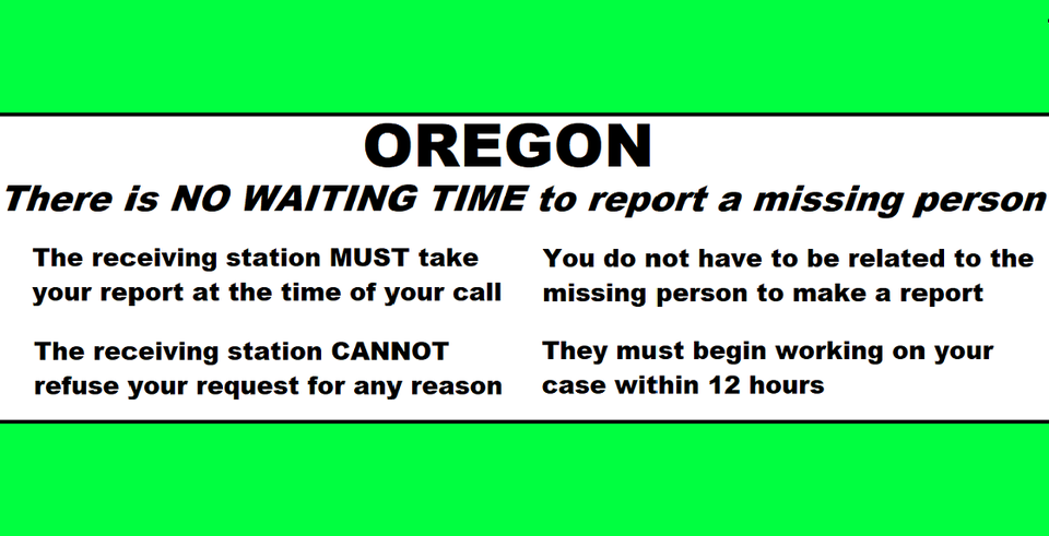
In Oregon we don’t have those rules and an officer or person answering the phone is not allowed to decide. The law decides. We have Senate Bill 351 and it states that the police CANNOT refuse a request for any reason and they must begin working on it within 12 hours. The person making the report does not have to be related to missing person either. Here is SB 351 written by families of the missing here in Oregon in conjunction with Oregon law enforcement officers. This should be common knowledge, please make it this way. https://olis.oregonlegislature.gov/…/SB351/Introduced
Find the mental health support you need

Click to see all resources https://oregonhealthnews.oregon.gov/find-the-mental-health-support-you-need/?utm_medium=email&utm_source=govdelivery

 Oregon State Police are reminding parents and students of the SafeOregon hotline. It takes reports of potential threats against students and schools. The tips can be made anonymously. They can include safety threats, fights, drugs, weapons on campus, cyberbullying and students considering self-harm or suicide. A technician reviews the reports and assigns them either to police or school administrators. Tips can be made by phone, text, email or on the website https://www.safeoregon.com
  Call us at 5 41-363-7503 Or email us at Info@RogueValleyMagazine.com