
The latest news stories of interest in the Rogue Valley and the state of Oregon from the digital home of Southern Oregon, Wynne Broadcasting’s RogueValleyMagazine.com
Wednesday, August 5, 2026
Rogue Valley Weather

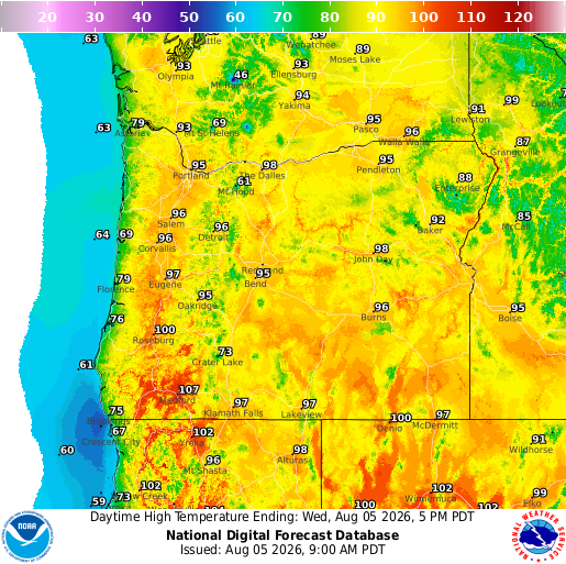
https://graphical.weather.gov/sectors/oregon.php
 https://graphical.weather.gov/sectors/oregon.php
Please pay close attention to the conditions across the state. The National Weather Service has issued Red Flag Warnings and Fire Weather Watches for a large portion of the Oregon
The National Weather Service issued a red flag wildfire warning. Forecasters issue a red flag warning when weather conditions pose an increased threat of rapidly spreading wildfire.

It’s already extremely dry. Our ask: prevent sparking a wildfire. Check your tow chains. Don’t mow tall dry grass in the heat of the day Don’t park on tall dry grass
We’ve got prevention tips posted to our website to share with your friends and family. LEARN MORE: https://www.oregon.gov/…/pages/prevent-wildfires.aspx

 Today the National Weather Service issued a Red Flag Warning for the Rogue Valley alongside a Heat Advisory. This combo plus gusty winds results in prime conditions for extreme wildfire danger.
 Emergency Alerts: https://member.everbridge.net/76864345342052/login Know Your Zone: https://protect.genasys.com/search Emergency Kits: https://rvem.org/Get-Ready-Rogue/Kit-Types WatchDuty: https://app.watchduty.org/
As of 12:01 a.m., Industrial Fire Precaution Level (IFPL) 3 is now in effect on lands protected by the Oregon Department of Forestry’s Southwest Oregon District in Jackson and Josephine counties. The Fire Danger Level remains at Extreme.

Under IFPL Level 3:
The following activities are prohibited between 1:00 p.m. and 8:00 p.m.:
- Power saws at loading sites
- Loading or hauling of any product or material
- Blasting
- Welding, cutting or grinding of metal
- Any other spark-emitting operation not specifically mentioned
The following operations may only operate between 8:00 p.m. and 1:00 p.m., provided mechanized equipment capable of constructing fireline is immediately available:
- Ground-based logging operations
- Power saws on ground-based operations
- Rotary head saw feller-bunchers with a continuous Firewatch
- Non-rotary head saw feller-bunchers
- Tethered logging systems
- Cable yarding systems are prohibited at all times, except for limited exceptions outlined in the IFPL 3 Closedown Order.
- The Firewatch requirement is reduced from a minimum of three hours to two hours during breaks and at the end of the operating period.
For more information about fire season restrictions, visit www.swofire.com or follow ODF Southwest Oregon District on Facebook.
𝗘𝗔𝗦𝗧 𝗘𝗩𝗔𝗡𝗦 𝗖𝗥𝗘𝗘𝗞 𝗙𝗜𝗥𝗘 𝗥𝗘𝗔𝗖𝗛𝗘𝗦 𝟵𝟱 𝗣𝗘𝗥𝗖𝗘𝗡𝗧 𝗖𝗢𝗡𝗧𝗔𝗜𝗡𝗠𝗘𝗡𝗧 𝗔𝗦 𝗧𝗥𝗔𝗡𝗦𝗜𝗧𝗜𝗢𝗡 𝗧𝗢 𝗟𝗢𝗖𝗔𝗟 𝗢𝗗𝗙 𝗧𝗘𝗔𝗠 𝗔𝗣𝗣𝗥𝗢𝗔𝗖𝗛𝗘𝗦:
Firefighters continued making strong progress Wednesday as mop up, suppression repair, and rehabilitation efforts moved closer to completion across the East Evans Creek Fire.
The fire remains at 15,580 acres and is now 95% contained. Crews completed backhauling operations Tuesday, removing hose, equipment, and other firefighting resources from the fireline. Firefighters are now focused on completing suppression repair, restoring impacted areas, and continuing mop up in locations where isolated heat remains.
Infrared reconnaissance and routine monitoring continue to identify occasional hotspots within the fire perimeter. On Tuesday, a helicopter completed a bucket drop to cool a small area of residual heat along the north side of the fire. While firefighters continue extinguishing remaining hotspots, light interior smoke will remain visible at times as heavier fuels continue to smolder well within the established containment lines. Smoke visible from surrounding communities does not necessarily indicate new fire growth, and crews continue to monitor the fire closely each day.
On Saturday, the Florida Complex Incident Management Team 1 will complete its deployment and transition management of the East Evans Creek Fire to a local Oregon Department of Forestry Type 3 Incident Management Team. The Florida Complex Incident Management Team 1 is sincerely grateful to the community for its patience, support, and cooperation throughout the incident. The local ODF team will continue overseeing mop up, ongoing monitoring, suppression repair, and rehabilitation efforts until the fire is fully secured.
This will be the final scheduled update on the East Evans Creek Fire unless conditions change significantly.
5:00 AM | 8/5/2026 – Vegetation fire in Sams Valley


8/4/26, 19:45 hrs. (EAST GRANTS PASS) — A wildfire reported to Grants Pass 911 near Tom Pearce Park mobilized firefighters from Rural Metro Fire, Grants Pass Fire and ODF Southwest Oregon District, launching an aggressive ground and air attack, eventually holding the fire at just under 1 acre.

An investigation is underway after a fire broke out in White City on Saturday.
According to Jackson County Fire District 3, crews responded to a second-alarm commercial structure fire at 2645 Avenue G. The fire later escalated to a third alarm and spread to nearby businesses.

Allied Environmental Services (AES) lost several buildings and recyclable materials in the fire. Nearby businesses, Radius Recycling and Tehama Tire, also sustained damages.
Firefighters were able to stop the fire before it spread onto the nearby U.S. Department of Veterans Affairs property.
Fire investigators say they have identified the fire’s point of origin, a key step in determining its cause. The investigation remains ongoing, and no cause has been released.
Wildlife Images Rehabilitation & Education Center is with Wooldridge Creek Vineyard. Join us on Saturday, August 15, from 4:00-6:00PM at Wooldridge Creek Winery for a special opportunity to witness the release of three rehabilitated barn owls back into the wild!


Asante to End Outpatient Rehabilitation Services in Grants Pass and Medford
Asante Health System will permanently close its outpatient rehabilitation clinics in Grants Pass and Medford on Aug. 28, ending a range of physical therapy, occupational therapy and speech-language pathology services that have supported patients recovering from injuries, surgeries, neurological conditions and chronic illnesses throughout Southern Oregon.
The decision marks another significant operational change for the region’s largest nonprofit health care provider as it continues adapting to financial challenges that have affected hospitals and health systems across Oregon and the nation. While demand for rehabilitation services remains strong, Asante has indicated that mounting economic pressures have made it necessary to reevaluate how and where health care services are delivered.
According to the health system, the closure is part of a broader effort to strengthen its long-term financial stability while preserving essential hospital operations. Asante has consistently cited rising operating expenses, increasing labor costs, higher prices for medical supplies and pharmaceuticals, and reimbursement rates that have failed to keep pace with the actual cost of providing patient care.
Health system leaders have explained that one of the most significant challenges facing Asante is the growing gap between the cost of delivering health care and the reimbursement received from government insurance programs. Medicare and Medicaid now account for a substantial share of the organization’s patient population, while the percentage of patients covered by commercial insurance has steadily declined. Because government reimbursement often falls below the cost of providing many medical services, hospitals have experienced increasing financial strain even as patient volumes remain high.
As the Aug. 28 closure date approaches, patients receiving outpatient rehabilitation services are expected to receive additional information regarding the continuation of their care. The announcement represents another example of the financial realities confronting hospitals throughout Oregon as health systems work to balance growing demand for medical services with the economic challenges of delivering care in an increasingly complex health care environment.
Rogue Valley Named America’s Top Wine Region by USA Today
The Rogue Valley has earned national recognition after being named the Best Wine Region in the United States in USA Today’s annual “10 Best” rankings. https://10best.usatoday.com/awards/rogue-valley-oregon/

USA Today praised the region for its diverse landscape, noting that its varying elevations and unique microclimates allow growers to produce a wide variety of grapes. That diversity creates distinctive wines and has helped establish the Rogue Valley as one of North America’s premier wine destinations.
Wine enthusiasts will find plenty to explore. Jackson County alone is home to approximately 45 wineries, according to the American Winery Guide, offering everything from intimate tasting rooms to scenic vineyard experiences.
Beyond the vineyards, visitors can enjoy some of Southern Oregon’s most beautiful outdoor attractions. Popular destinations include Mount Ashland, Roxy Ann Peak, and the Upper and Lower Table Rocks. Crater Lake National Park and California’s Redwood National Park are also just a short drive away.
USA Today also highlighted the region’s outdoor recreation, saying the combination of world-class wines and easy access to hiking, sightseeing, and other adventures makes the Rogue Valley a favorite destination for travelers.
Mt. Ashland Ski Area is set to revive its drive-in movie series this summer, following a successful inaugural season last year. The lineup features a selection of classic films
This will be succeeded by the original Mary Poppins and the iconic horror film Night of the Living Dead, presented in its original black-and-white format. The series will conclude with the cherished Pacific Northwest favorite, The Goonies.
Screenings will take place in the Mt. Ashland parking lot, where attendees are encouraged to bring blankets, chairs, or utilize the back of their trucks for a comfortable viewing experience under the stars. Snacks and beverages will be available for purchase, with tickets priced at $30 per vehicle, which can be acquired through mtashland.com.
The highly anticipated trial of Dani Marie Schofield in Jackson County will be presided over by retired Senior Judge Lorenzo Mejia, who has been out of the judiciary for three and a half years.
The case involving Schofield, a former nurse at Asante Rogue Regional Medical Center, faces 44 counts of second-degree assault.
Allegations against her include diverting prescribed fentanyl from patients and substituting it with tap water, which reportedly led to infections among those patients.
The trial, originally scheduled for September, was postponed at the request of Schofield’s defense team, and a new date has yet to be established. Additionally, District Attorney Patrick Green expressed his discontent with Presiding Judge David Hoppe’s decision to appoint Mejia in a letter sent last week.
40 Modular Homes to Be Built in Phoenix to Replace Homes Lost in Almeda Fire
Oregon Housing and Community Services selected five projects to build 117 affordable homes using factory-produced housing methods across the state.
AGE+ and Blazer Modular Construction plan to use the funding to build 40 fully accessible, affordable homes for older adults in Phoenix. The project, Phoenix Commons, will replace housing lost in the Almeda Fire. The modular construction will reduce per-unit costs and cut the construction schedule by several months.
The initiative comes from House Bill 3145 passed in the 2025 Legislative Session. It will fund up to five factory-produced housing projects with Local Innovation and Fast Track set-aside funds totaling $25 million. Factory-produced housing, like modular homes, offers an alternative to traditional construction and can produce homes faster and at lower costs.
 ACCESS – NEW location: Talent Food Pantry at the 𝗧𝗮𝗹𝗲𝗻𝘁 𝗛𝗲𝗮𝗹𝘁𝗵 𝗖𝗲𝗻𝘁𝗲𝗿, located at 49 Talent Ave. in Talent.
City of Roseburg Government — Wondering where to get the facts about City projects, plans, decisions, events and upcoming meetings?
𝗙𝗲𝗮𝘁𝘂𝗿𝗲𝗱 𝗙𝗼𝗼𝗱 𝗣𝗮𝗻𝘁𝗿𝘆: 𝗦𝗮𝗹𝘃𝗮𝘁𝗶𝗼𝗻 𝗔𝗿𝗺𝘆 𝗣𝗮𝗻𝘁𝗿𝘆 


Southern Oregon PBS Still on The Air Despite Federal Funding Loss

Rogue Valley Humane Society
Our Community Food Bank exists to help folks who need an extra helping hand during a difficult month to feed their pets. Our program has a limited budget and so we rely on generous members of our community to donate some of these goods to continue to help assist our community. In 2023 we fed an average of 700 pets a month!
This equates to approximately 70 – 40lb bags of food each month! Many pets have benefited from the community’s generosity, and we can’t thank you enough for your kindness.
CSO Case 24-4928 PROSPECT, Ore. – Jackson County Sheriff’s Office (JCSO) detectives and Search and Rescue (SAR) personnel continue to search for a woman missing out of Prospect, Ore. since September 2024.
Deenah Padgett, 69, was reported missing on Sunday, September 8, 2024. She was last seen camping in the Prospect area on September 4, 2024.
She is described as a white woman with brownish-red, partially gray hair, standing 4’8” tall and weighing 90-100 lbs. JCSO detectives and SAR personnel have searched the area extensively and are looking for the public’s help. If you see Deenah or know her whereabouts, immediately call ECSO Dispatch at (541) 776-7206 and reference case 24-4928.
If you have any information that might help the investigation, call Detective Friend at (541) 864-8774.
The Jackson County Sheriff’s Office (JCSO) is asking for help identifying the owner a motorhome. It could be associated with a missing person from the Prospect area. JCSO says 68-year-old Deenah Padgett has been missing since August 30 from Prospect, described as a white woman, 4’ 8” tall, weighing approximately 95 pounds with brownish red/greying hair. JCSO issued an advisory this weekend asking anyone with information about the owner of the pictured motor home or Padgett’s whereabouts to call Emergency Communications of Southern Oregon (ECSO) dispatch non-emergency phone number at 541-776-7206.
David Grubbs’ Murder Investigation Remains Active
The Ashland Police Department’s investigation into the murder of David Grubbs on November 19, 2011 remains open and active. Recently two new detectives have been assigned to look into new leads that have come in.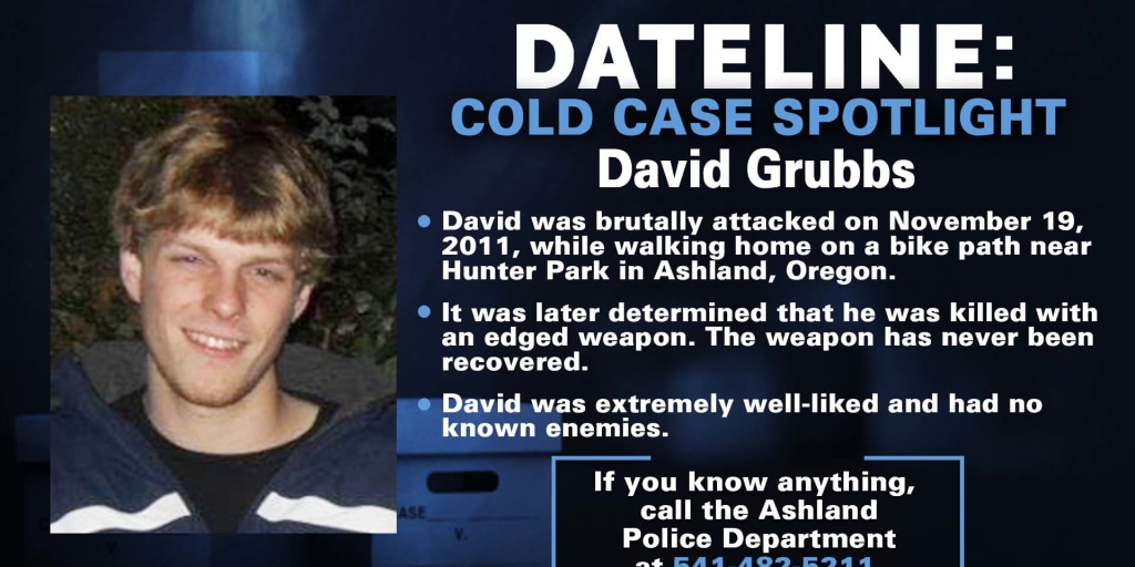 This case remains important to David’s family, the community, and the Ashland Police Department. As detectives continue to pursue these new leads, anyone with additional information is encouraged to reach out to the Ashland Police Department at 541-488-2211. The reward for information leading to an arrest on this case remains at over $21,000.
Taking Another Look at What Happened to Fauna Frey
Fauna was grieving the recent death of her brother, Dallas, when she set off from Eugene in June of 2020 heading to Grants Pass on what her family believes was both a healing trip and a mission to deliver gifts, silver coins inherited from Dallas, to a few friends. But somewhere between motel check-ins and checkouts, something went terribly wrong. Her Jeep was found months later. She was never seen again. http://bit.ly/4l63Dle

We will start resharing podcasts and articles. For starters here is a story from Danielle Denham that appeared in the June 29, 2025 edition of That Oregon Life. Ms Denham worked closely with us to insure that the facts she presented were accurate. Check out the nine episodes of the podcast Nowhere to be Found, a comprehensive, in-depth, sensitive treatment of the details surrounding Fauna’s disappearance. Hear from Fauna’s father, John, and her friends. Posted in spring of 2022, Amanda Popineau shares Fauna’s journey and the mystery that surrounds it. Go to Nowhere to be Found Season Two: Episode One “Under A Half-Moon.”
https://podcasts.apple.com/kg/podcast/s2e1-under-a-halfmoon/id1532686678?i=1000512098162
We want to remind people that Fauna’s father is offering a reward for information that brings Fauna home. Please if you have any information no matter how big or small let us know by calling the anonymous tip line or emailing. Tipline- 541-359-5638 Email – Helpfindfaunafrey@gmail.com FOLLOW on FACEBOOK GROUP: https://www.facebook.com/groups/341658526970132
Have Information on Fauna Frey? Please Speak Up!
If you know anything, no matter how small, please contact:
- Josephine County Sheriff’s Office
- Tip line: (541) 359-5638
- Email: FindFaunaFrey@gmail.com
Currrently there is a $50,000 CASH REWARD for information leading to the location of Fauna Frey. LARGE CASH REWARDS are being offered for any other relevant information, such as any objects that could be identified as Fauna’s, i.e. her wallet, keys, or Indian/Buffalo .999 silver bullion coins. Find Fauna Frey Facebook Group: https://www.facebook.com/groups/341658526970132
You can find food in your community at this link
Our network of food banks and pantries provides free food and groceries across Oregon. No proof of income or documentation required.
https://www.oregonfoodbank.org/
If you can’t make it to a food location, someone else can pick up food for you.You will just need to print and fill out the Authorized Representative form at https://lnkd.in/dsskUpkQ, and have them take it with them to the food sites. You can find step-by-step instructions at https://lnkd.in/dVBRxn-A.
Worried about recent changes or losing assistance?
Here are resources that can help: 211Info: Dial 2-1-1 or visit the211Info food webpagefor information and referrals to more than 1,500 food resources across Oregon. Oregon Food Bank: Use the Oregon Food Bank’s Food Finder Map to find over 100 food pantries, free food markets or hot meal programs near you. Aging and Disability Resource Connection of Oregon (ADRC): Call 855-673-2372 or visit theADRC food webpage to find local meal programs and food boxes in your area.

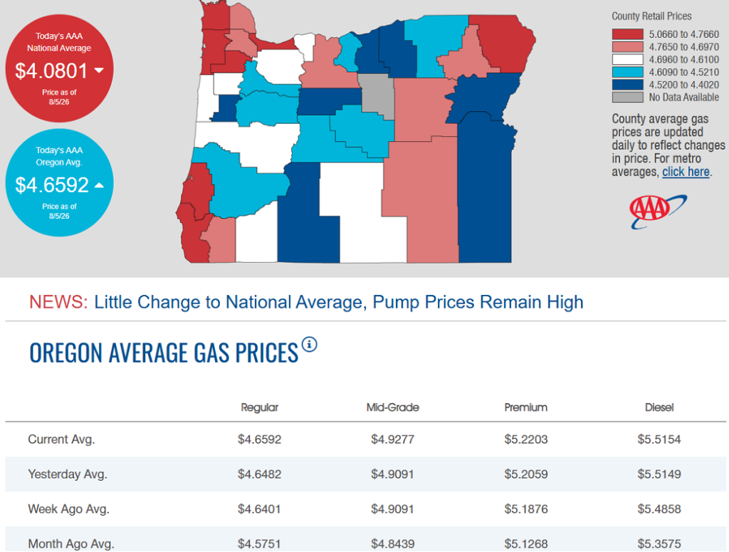
8/5/2026 — Gas Prices in Oregon Today
Oregon on track to have one of its most harmful and expensive wildfire seasons in history.
As dozens of wildfires continue to burn across Oregon, state officials say fire suppression efforts this year have cost the state more than $150 million so far, a number likely to grow significantly in the coming months.

Courtesy of Brett Deedon, Oregon State Fire Marshal
Oregon appears to be on track to have one of its most harmful and expensive wildfire seasons in history. In 2024, public agencies spent $350 million on firefighting efforts when a record 1.9 million acres burned. Just days into August, the state has surpassed that record with more than 2 million acres burned. (READ MORE)
Oregon state agencies remind everyone to be informed and prepared

— With the National Weather Service issuing a fire weather watch for Saturday across large portions of north‑central, northeast and southeast Oregon, the state’s public safety services, natural resource agencies, and tourism office want to remind residents and visitors to practice wildfire prevention, prepare their home and a go-bag for evacuation, and know where to go for real-time alerts and information.
According to the Northwest Interagency Coordination Center’s predictive services, each year the Pacific Northwest is at elevated risk of significant fires from now until October.
With fire crews responding to new fire starts every day, Oregonians and our visitors need to be prepared for wildfires, help prevent future ones, and be aware of up-to-date conditions as they travel across the state.
How can people help prevent wildfires?
The Oregon Department of Forestry is urging the public to actively practice wildfire prevention as the state continues to put out new fires every day. Additional human-caused fires on the landscape will draw the firefighting efforts away from the lightning-caused fires and put extra strain on ground and aviation resources, which are already spread thin. YOU can help prevent wildfires by:
- Checking and following your local fire regulations. The majority of the state is either in high or extreme fire danger right now, meaning even the smallest of sparks could start the next large wildfire.
- Debris burning may be prohibited where you live.
- Check local restrictions or contact your local ODF office.
- Return to check on your burn site if you burned earlier in the year.
- Make sure your car has been recently serviced to avoid faulty parts throwing sparks.
- Don’t drag tow chains.
- Avoid parking vehicles on tall, dry grass.
- Recreate responsibly. Where campfires are allowed, make sure your campfire is DEAD OUT before leaving it by drowning it with water, stirring it with a shovel and repeating that process until it is cold to the touch. If there is heat coming off it, there are still embers that could reignite.
Take Simple Steps to Protect Your Home from Wildfire
The Oregon State Fire Marshal reminds Oregonians that summer is not the safest time to tackle large landscaping or defensible space projects. Hot, dry conditions increase the risk of starting a fire from using tools or equipment. There are small, safe steps you can take now to reduce wildfire risk around your home. The Oregon State Fire Marshal encourages everyone to plan ahead and do light cleanup tasks that protect your property without increasing fire danger.
Easy tasks to reduce risk in the first five feet around your home:
- Clear leaves, pine needles, and other debris from your roof, gutters, and under decks.
- Trim plants and bushes that are touching your home or growing under roof eaves. Give trees and shrubs space from each other and from structures.
- Remove dead plants and wood mulch. Use nonflammable materials like rocks or gravel near your home. Avoid bark mulch or dry grasses right next to buildings.
- Move firewood, propane tanks, and other flammable items at least five feet away from your home.
- Cover attic vents, soffit vents, and spaces under decks with 1/8-inch metal mesh to block embers.
Avoid using power tools or equipment that could spark a fire, especially during the heat of the day. Summer is a good time to plan defensible space projects, so you’re ready to work safely once wildfire season ends.
For more tips or help with defensible space, visit www.oregondefensiblespace.org or https://preventwildfires.oregon.gov.
How can I prepare myself in case I need to evacuate?
The Oregon Department of Emergency Management (OEM) urges everyone to prepare for wildfires and other emergencies by knowing evacuation levels, staying informed, having a plan, and having a go-kit ready.
Evacuation Levels
- Oregon follows a three-level evacuation notification system, each structured around safety threat level.
- Oregonians should become familiar with “Be Ready, Be Set, Go!” evacuation levels to make informed decisions when receiving evacuation notices.
- OEM urges people to evacuate whenever they feel unsafe, conditions can change rapidly; individuals should always make the best decision for their safety.
- Following evacuation, people should not return to the area until public safety officials state it is safe.
Stay Informed
- Stay informed, sign up to receive evacuation at, ORAlert.gov remember to update information if need be.
- Find the websites for your county emergency management, sheriff’s office, or tribal police and follow them on social media.
- Check your phone settings to ensure wireless emergency alerts are turned on.
- Build redundancy into how you can access alerts. Have a personal C.E plan for what you will do if your cell phone stops working. A good place to start is a hand-cranked NOAA radio.
- If you use a third-party app for alerts and situational awareness and notice discrepancy information, default to the information provided by your local emergency management office.
Have a Plan
- Do you know what to do during an evacuation? This evacuation checklist explains what to do before, during and after an evacuation.
- Establish a communication plan with a list of important contacts and a safe place for loved ones to meet if they are separated during an emergency.
- Identify multiple evacuation routes from home, work, or school and plan for transportation needs.
- People with disabilities should consider individual circumstances and specific needs when planning for evacuation, such as special equipment, transportation, and service animals. Then plan extra time, when possible, this may mean treating a level 2 notice like a level 3 notice.
- Have an evacuation plan for pets, make a pet evacuation kit in a tote bag or pet crate, and plan for transportation and sheltering of large animals such as horses and other livestock.
Make a Go-Kit
- Assemble an emergency kit of essential supplies that can be grabbed quickly.
- Pack an easy-to-carry backpack or bag for each household member with health and safety items such as food, water, medication, flashlights, phone chargers, clothing, and important documents. Visit American Red Cross to learn more.
- Find more information and resources at Wildfire.Oregon.gov.
Recreate Responsibly
Oregon Parks and Recreation Department (OPRD) encourages visitors to know before they go when it comes to campfire restrictions. OPRD coordinates with local fire officials throughout the summer and bans open flames in high-risk areas around the state until conditions improve. Please check park webpages or the current fire restrictions list before your next visit. Thank you for helping to reduce the risk of wildfires.
Additionally, many waterways in eastern Oregon are currently being used by firefighting aircraft. Stay clear of the center of major waterways. Recreational boats can block aircraft from accessing the water, which means they will not be able to retrieve water to help put out nearby wildfires.
Occasionally, OPRD will need to evacuate a state park. Evacuations occur at level 2 or earlier depending on fire conditions and the time required to get in and out of the park. Please follow park ranger instructions to pack gear and evacuate. Any park closure information will be posted on the park web page and OPRD social media.
How do I know if I should change my vacation plans?
Oregon is a large state, and while wildfires can disrupt travel in some regions, those impacts are often localized and can change rapidly as conditions improve or deteriorate. Because of this, it’s important to check current alerts at the resources below to see whether your destination is affected. If you’re looking for general guidance about traveling during wildfire season, read Travel Oregon’s Wildfire Travel FAQ.
Before You Go:
- Check road conditions at TripCheck.com or by calling 511.
- Review and follow all local fire restrictions and closures.
- Be aware of air quality conditions that could impact health and visibility.
- View real-time hazard updates, maps, and fire information through OEM’s Wildfire Dashboard.
- Sign up for emergency alerts at ORAlert.gov and ensure Wireless Emergency Alerts are enabled on your mobile device.
Oregon Division of Financial Regulation offers insurance tips for Oregonians affected by wildfires

The Oregon Division of Financial Regulation (DFR) has tips for homeowners and renters who have evacuated or been affected by wildfires, smoke, or ash damage.
“We know this is a hard time for many Oregonians as wildfires affect communities across the state,” said Oregon Insurance Commissioner TK Keen. “We want people to have these tips so they know what their insurance covers and what steps to take if they are affected by a wildfire.”
- If you were evacuated, save your receipts. Your homeowners policy may pay for expenses such as lodging, food, and even pet boarding due to a mandatory evacuation. Be sure to check with your insurance company or agent to confirm your specific coverage. Coverage is typically available for fire, smoke, and ash damage to your home and personal property.
- Additional living expenses (ALE) are typically subject to your deductible, so before you file a claim, be sure it makes sense to do so. It is important to note that a claim can be counted against you for underwriting purposes, even if the insurance company does not make a payment. Most homeowners and renters’ insurance policies help pay for extra expenses such as ALE if you are unable to live in your home. Every company handles these expenses differently. Check with your company or agent for specifics.
- If you have not evacuated and it is safe to do so, make a quick home inventory list by taking photos or video of each room in your home. Pay close attention to what is on the walls and in drawers and closets. Don’t forget storage areas such as the attic and garage. You can also check your insurance company’s website for an app or checklist that will help. Creating that list will help you after a fire or disaster. If your personal belongings are damaged, the insurance company will request a list of items that are damaged or destroyed. Take some time to work on your home inventory list now. Look through your photos and videos to help recall personal items. Be sure to look for smaller items, such as jewelry. To the best of your ability, write down the age, original cost, and replacement cost of each item.
- Ask about your auto coverage, too. You need comprehensive coverage on your auto policy to cover fire, smoke, and ash damage, no matter where your vehicle is located at the time of loss.
Following these tips will help save you money, time, and stress during a wildfire and its aftermath. For more information on preparing for a wildfire, visit DFR’s wildfire page.
If you still have questions or concerns, DFR’s consumer advocates are here to help. Call the team at 888-877-4894 (toll-free), email them at .insurancehelp@dcbs.oregon.gov“>dfr.insurancehelp@dcbs.oregon.gov, or visit dfr.oregon.gov.
### About Oregon DFR: The Division of Financial Regulation protects consumers and regulates insurance, depository institutions, trust companies, securities, and consumer financial products and services. The division is part of the Department of Consumer and Business Services, Oregon’s largest consumer protection and business regulatory agency. Visit dfr.oregon.gov and dcbs.oregon.gov.

 PACIFIC NORTHWEST WILDFIRE UPDATE
Oregon is currently home to the four largest active wildfires in the United States, with the fifth largest burning in Washington, as fire activity remains elevated across the Northwest and much of the West.
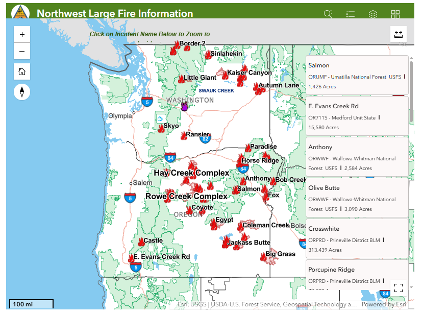
Washington and Oregon continue to battle an extraordinary wildfire season, with more than 1.72 million acres burning across dozens of large active fires.
Washington: 205,055 acres are burning across 12 major incidents, led by the Kaiser Canyon Fire (126,402 acres).
Oregon: 1,516,034 acres are burning across 22 large fires, with the Rowe Creek Complex (294,000 acres) and Big Grass Fire (292,087 acres) among the largest in the nation.
Firefighters continue working around the clock in steep terrain, extreme heat, low humidity, and challenging wind conditions to protect lives, homes, and critical infrastructure. Many communities remain under evacuation notices or heightened fire weather concerns, and conditions can change rapidly.
Please continue to respect closures, follow evacuation orders immediately if issued, and give emergency responders the space they need to do their jobs safely.
 To all firefighters, dispatchers, aviation crews, law enforcement, EMS, and support personnel—thank you for your dedication and sacrifice.Stay informed. Stay prepared. Stay safe.
8/5 – WILDFIRE UPDATES of all Oregon Counties
Updated Evacuation information, Acres, and Containment #FireUpdates #oregonfires
REPORT: 6 am #fireevacuations
**JACKSON COUNTY #jacksoncounty
EAST EVANS CREEK FIRE – 18900 Block of E Evans Creek Rd. APPROX 14 miles NE of Rogue River
15,580 ACRES
95% contained
Evacuations still lifted
———————————————-
*(JOSEPHINE COUNTY) #josephinecounty
– I-5 MM 57 NB FIRE
-Area of I-5 & NE Beacon Dr., Grants Pass #josephinecounty 100 ACRES
23% containment
REDUCED TO LEVEL 1
———————————————
**(BAKER COUNTY) #bakercounty
–Fox Fire- Fox Creek Rd, Huntington; Baker County-
79,008 Acres- 61% Containment
EVAC LEVEL 3 / LEVEL 2
LEVEL 1
–Powder River Fire-Southwest of Richland; Baker County-
21,088 Acres- 96% Containment LEVEL 3 / LEVEL 2
#bakercounty
–Anthony Fire-2 Miles North of Anthony Lakes; Baker & Union Counties-2
2,584 Acres-89% Containment
LEVEL 3/ LEVEL 1
–Bob Creek Fire- East of Forest Rd., & West of Homestead Rd.,
Oxbow Area; Baker County
851Acres-
72% Containment
LEVEL 3 GO NOW
————————————————
**(CROOK COUNTY) #crookcounty
–Henry Fire (497) 1.7 Miles South Paulina; #crookcounty
29,888 Acres- 92% Containment
LEVEL 2/ LEVEL 1
–Coyote Fire (500) 22300 Block of Newsome Creek Rd., Post; #crookcounty
17,4.88 Acres-
89% Containment
LEVEL 2
LEVEL 1
———————————————-
**(GRANT COUNTY) #grantcounty
–Olive Butte Fire-South of Granite; USFS 050 Rd., Sumpter
3,090 Acres-66% Containment
LEVEL 2
–Bologna Fire- 9 Miles Northwest Monument; Grant County-
2,425 Acres- 98% Containment #grantcounty
–Salmon Fire-½ Mile Northwest of Greenhorn; Grant County-
1,426 Acres-79% Containment
EVAC – LEVEL 2
———————————————
**(HARNEY COUNTY) #harneycounty
–Coleman Creek Fire-8 Miles Southwest of Warm Springs Reservoir; Malheur & Harney Counties
278,422.3 Acres-
32% Containment LEVEL 3
LEVEL 2 / LEVEL 1
–Second Flat Fire-Approximately 6 Miles NE of Hwy 20 and Hwy 395 Junction; Harney County-
105,462 Acres- 55% Containment
LEVEL 3 #harneycounty
LEVEL 2 / LEVEL 1
–Bald Mountain Fire-Off Dry Creek-McBain Flat Rd and East of Big Hill, East of Diamond-
78,239 Acres and 30% Contained LEVEL 1
–Jackass Butte Fire-Off Jack Mountain Rd near Jackass Mtn.
24,742 Acres
78% Containment #harneycounty
Evacuations Removed
–Stubble Fire- East of HWY 205 near Sodhouse Ln., South of Malheur Lake- Harney County-
15,673 Acres-93% Containment #harneycounty EVACS Removed
–Egypt Fire- Just South of Emigrant Butte., 13 miles North of Riley;
4,553 ACRES
82% Contained #harneycounty
Evacuations Removed
–Crater Fire- Northwest of Diamond Crater; Harney County-
705 Acres- 97% Containment #harneycounty EVACS removed
———————————————-
**(JEFFERSON COUNTY) #jeffersoncounty
**ROWE CREEK COMPLEX
#crookcounty #wheelercounty #wascocounty #jeffersoncounty
325,265 ACRES
57% contained
**ROWE CREEK COMPLEX / WEST ZONE
Near Brewer Reservoir Approx 11.5 miles – East of Madras #crookcounty
#JeffersonCounty
LEVEL 3
( GO NOW)
LEVEL 2 ( BE SET)
LEVEL 1 ( BE READY)
**ROUND BUTTE FIRE (0658)
5500 Block of SW BOULDER LN., Culver #jeffersoncounty
1,163.1 ACRE
56% contained
EVACUATION: LEVEL 3
GO NOW
LEVEL 1
( BE READY)
–AKAWA BUTTE FIRE
-9 Miles Northwest of Crooked River Ranch; Jefferson & Deschutes Counties- 27,491 Acres-
99% contained
ALL EVACUATIONS LIFTED #deschutescounty #jeffersoncounty
–Bench Fire-9 Miles Southwest of Warm Springs; Jefferson County- 67,079.5 Acres-
84% Containment –
LEVEL 2 / LEVEL 1
merged with larger fire –
———————————————-
**(MALHEUR COUNTY)
#malheurcounty
–Big Grass Fire
– Skull Creek Rd., & Upper Horse Camp Reservoir Rd. Jordan Valley #malheurcounty #owyeecounty
349,081.9 ACRES
35% containment
LEVEL 3 / LEVEL 2
LEVEL 1
–Hat Fire-Approximately 1mi East of Hat Butte; Malheur County-
44,122 Acres-
99% Containment
#malheurcounty
Evacuations Removed
————————————————-
**(UMATILLA COUNTY)
#umatillacounty #unioncounty
–HORSE RIDGE FIRE
– East of Klondike Creek, near NF Road 050, S/W of Duncan #umatillacounty
860 Acres
98% Containment
Evacuations Removed
–HAGEN FIRE
– Hagen Creek / Hagar Ridge -South of Bingham Rd., Approx. 4 miles East of Gibbon; #umatillacounty #unioncounty
40,804.3 Acres- 11% Containment
LEVEL 3 / LEVEL 2
LEVEL 1
——————————————-
**(WALLOWA COUNTY) #wallowacounty
–Burnt Creek Fire- Davis Creek, East of Hwy. 3 near Day Ridge intersection; Wallowa County
4,169 Acres-
70% Containment
EVACS REMOVED
#wallowacounty
–Paradise Fire-Area of Paradise Creek and the Mill Creek Watershed; Wallowa, Columbia, Walla Walla, Umatilla Counties-
1663.8 Acres-
0% Containment
#columbiacounty #wallawallacounty #umatillacounty
LEVEL 2 (BE SET)
LEVEL 1 (BE READY
————————————————
**(WASCO COUNTY) #wascocounty
–Little Buck Fire (567) – 2 miles East of Hwy. 97 at MM51-5.8 Miles Northeast of Shaniko; Wasco County-
43,818 Acres-
89% Containment #wascocounty
ALL EVACUATIONS REMOVED
–Grasshopper Fire-
0.3 Miles West of Rocky Butte / 12 Miles East of Government Camp; Wasco & Hood River Counties-
39,439 Acres-
19% Containment
LEVEL 3
LEVEL 2 – LEVEL 1
#hoodrivercounty #wascocounty
——————————————
**(WHEELER COUNTY) #wheelercounty
–Crosswhite East Fire (445) (Rowe Creek Complex)- Rowe Creek Rd., North of Twickenham; Wheeler, Crook, Wasco, & Jefferson
#wheelercounty #crookcounty #wascocounty #jeffersoncounty
Counties-
311,407.5 Acres-
55% Containment
LEVEL 3
LEVEL 2 / LEVEL 1
–Camel Hump Fire (446) (Rowe Creek Complex)-Between John Day River and Service – Creek 3 Miles Northwest of Richmond; Wheeler County-
6,789 Acres-
68% Containment
LEVEL 3
LEVEL 2 – LEVEL 1
#wheelercounty
–Shingle Fire – 1.5 miles East of Barnhouse Campground -13 Miles Southeast of Mitchell; Wheeler, Grant, & Crook Counties-
70,569.7 Acres-
50% Containment
#wheelercounty #grantcounty #crookcounty
EVAC: LEVEL 3/ LEVEL 2
and LEVEL 1
Governor Kotek presses feds to get Oregon farmers, ranchers same urgent wildfire relief as red states
‘Oregon asks for the Utah clock,’ Gov. Tina Kotek wrote in a letter for immediate and robust aid to Oregon farmers and ranchers hit by wildfires

The Akawa Butte Fire in Central Oregon on July 22, 2026. (Photo courtesy of the Oregon Department of Forestry)
Oregon Gov. Tina Kotek is urging federal officials to help Oregon farmers and ranchers respond to, and rebound from, wildfires at the same scale and speed those officials delivered in Republican-controlled states hit by natural disasters this year.
In a letter requesting aid that Kotek sent Thursday to Brooke Rollins, head of the U.S. Department of Agriculture, and Doug Burgum, head of the U.S. Department of the Interior, Kotek wrote: “Oregon asks for the Utah clock.”
Immediately following early July fires that broke Utah’s 10-year records, USDA officials made available to ranchers and farmers in the state the full suite of federal loan, reimbursement and grant programs for losses and rebuilding, as well as expedited permits and fee waivers for livestock that needed federal land to graze on.
Kotek has asked for the same as more than 80 fires, including the four largest wildfires in the nation at present, burn across more than 1 million Oregon acres. That’s three times the amount that burned all of last year, and early in a wildfire season that still has up to three more months to go and two of the hottest and driest to come.

Kotek sent her letter just one day after the Federal Emergency Management Agency approved firefighting assistance grants for three Oregon fires but denied assistance that Kotek requested for two others. The grants are meant to help cover the majority of a state’s costs fighting specific fires that threaten to become a major disaster.
Kotek’s reminders in her request to Rollins and Burgum that they promised and delivered aid this year in the immediate aftermath of natural disasters in Nebraska, Texas and Utah reflect concerns that the agency under President Donald Trump is selectively approving aid based on the political makeup of the state’s leaders.
A federal lawyer earlier this month admitted the administration withheld federal grants to states based on whether voters backed Trump or former Vice President Kamala Harris in the 2024 presidential election, as well as whether the state had two Democratic senators. And a recent Politico analysis found Trump in his second term has approved less than 25% of requests for disaster aid from blue states, compared to nearly 90% approval for red state requests.
Kotek in her letter requested a wildfire disaster designation for 14 counties, which would allow farmers and ranchers access to emergency loan and disaster relief programs. She also requested fence replacement funds for hundreds of miles lost to fires and temporary federal-land grazing permits and fee waivers for displaced livestock.
She asked Rollins and Burgum to ensure their agencies collaborate on aid with state officials and with the tribes in Oregon, and requested a written commitment from Rollins that the USDA’s new plans to reorganize its regional U.S. Forest Service offices will not interrupt any wildfire recovery work. Kotek asked that USDA appoint one contact for Oregon fire recovery to coordinate interagency work, “so the state works one door rather than six.”
Kotek wrote that the state, and its farmers and ranchers, have held up their side of the bargain, investing in post-fire recovery from major blazes during the last several years, as well as prevention, mitigation and response planning.
Oregon’s farmers and ranchers “will rebuild again,” she wrote. “What they ask of their government is not sympathy; it is speed.” (SOURCE)
Oregon agency issues emergency order to pause insurance cancellations due to wildfires

The Oregon Division of Financial Regulation has issued Wildfire Emergency Order and bulletin for people affected by the state’s growing wildfire situation.
This order requires all property and casualty insurance companies to take proactive measures to protect people in wildfire affected areas. The order:
- Suspends cancellations and nonrenewals
- Establishes a grace period for premium payments for all insurance policies issued, delivered, or covering a risk in the affected areas
- Extends all deadlines for policyholders to report claims or submit other communication related to claims
- Take all practicable steps to provide opportunities for policyholders to report claims
The order applies to all insurance companies transacting property and casualty insurance in Oregon. It provides temporary protections to policyholders in affected areas, including those in ZIP codes subject to wildfire evacuation notices as provided in the order. The emergency order follows Gov. Tina Kotek’s state of emergency declaration on June 16 due to the imminent threat of wildfires. Since that declaration, Gov. Kotek has invoked the Emergency Conflagration Act for 11 fires.
“Last week, I met with fire response teams and community members in Sisters currently challenged by the Akawa Butte Fire,” Governor Kotek said. “I could not be more proud of the way Oregon communities are supporting each other during this time, but the last thing anyone needs to worry about in this moment is losing their homeowners insurance. I’m taking immediate action with this directive to ensure that families and communities across the state that are or will be responding to the catastrophic effects of wildfires this summer are provided with stability and certainty during this ongoing wildfire state of emergency.”
The order protects consumers in ZIP codes under evacuation notices who may be required to leave their homes, businesses, or both, and may be unable to access their property, records, mail, internet, financial information, or other resources. Evacuation may also inhibit an insured’s ability to communicate with their insurer, make a timely premium payment, report a claim, document a loss, or perform other duties required under insurance contract terms.
Providing these temporary measures extends grace periods for premium payments and postpones cancellations and nonrenewals. They also provide relief from reporting and other required communication related to claims submission and processing for insureds, and they give relief from other duties of insureds that may be burdensome. These measures will help ensure that Oregonians do not lose insurance coverage because an evacuation notice or order was complied with.
“We issued this order to make sure evacuees and other Oregonians affected by these wildfires are able to access the insurance resources they need, especially while they are displaced,” Oregon Insurance Commissioner TK Keen said. “We appreciate all the work our state’s insurance representatives are doing to help their customers right now, and we encourage everyone to be patient and work together throughout the recovery process.”
If your home or property was damaged by the wildfires, contact your insurance company as soon as possible to discuss your situation and learn next steps. If you still have concerns, the division’s consumer advocates are here to help. Call 888-877-4894 (toll-free) or email dfr.insurancehelp@oregon.gov .
Visit the DFR’s wildfire insurance resource page to view the order, bulletin, and more insurance information.
### About Oregon DFR: The Division of Financial Regulation protects consumers and regulates insurance, depository institutions, trust companies, securities, and consumer financial products and services. The division is part of the Department of Consumer and Business Services, Oregon’s largest consumer protection and business regulatory agency. Visit dfr.oregon.gov and dcbs.oregon.gov.
Statewide hotline available for Oregonians affected by wildfires and smoke
People anywhere in Oregon who have been affected by wildfires or wildfire-related air quality can call 1-833-699-0554 24 hours a day, seven days a week.


The statewide hotline is available to people experiencing any wildfire-related impact, including those who:
- Lost a home or property
- Evacuated and have ongoing needs
- Are sheltering in place and have wildfire-related needs
- Are affected by wildfire smoke or poor air quality
- Have another need or concern caused by a wildfire
“During this difficult wildfire season, Oregonians impacted by fires deserve immediate and reliable access to the help they need,” said Governor Tina Kotek. “That’s why we’ve established a dedicated, 24/7 hotline – so that no Oregonian has to navigate this wildfire season alone or wonder where to turn to for help.”
The hotline is staffed by 211info. If a call is not answered, callers can leave a message and will receive a return call within one business day.
This hotline does not provide emergency evacuation assistance or help people locate immediate shelter. People who are in immediate danger, have a medical emergency, or need emergency help evacuating should call 911. People looking for information about shelters or other immediate resources can call 2-1-1. For current 211info operating hours, visit 211info.org.
People can also enter their contact information and describe their wildfire-related needs using the Oregon Wildfire Assistance web form. An ODHS staff member will review the information and follow up with them.
“This wildfire season is already affecting a growing number of Oregon Tribes and communities,” said Ed Flick, Director, ODHS Office of Resilience and Emergency Management. “Wildfires can affect people in many ways, even when their homes have not burned. We want people to know there is one place they can call to share what they are experiencing and learn what resources may be available.”
In previous years the hotline has been used to connect people who lost homes in disasters with recovery support. This year, the Oregon Department of Human Services is expanding it to people experiencing a broader range of wildfire impacts.
ODHS has informally coordinated individual assistance following Oregon disasters since 2020. This year, Governor Tina Kotek directed ODHS to be ready to formally activate individual assistance when needed as the state prepares to establish a formal program in 2027 under House Bill 4121.
211info and ODHS will work with local communities to connect people with existing programs and local resources. If those resources are not enough to meet the level of need, ODHS will work with state leaders to identify additional support and funding options.
The hotline does not guarantee financial assistance or eligibility for a particular program. Staff will listen to each caller’s experience, document their needs and help identify available resources and next steps.
Hotline information
- Call: 1-833-699-0554
- Available: 24 hours a day, seven days a week
- Missed calls: Leave a message and your call will be returned within one business day
- Shelter and other immediate resource questions: call 211
- Emergencies or emergency evacuation help: call 911
The Lloyd Center Mall in Portland, which has been in operation for over 60 years, is set to close this Saturday, and a variety of activities are scheduled for its final week.
Among these is Prom on Ice, taking place this Friday evening, where participants will don formal attire and vintage prom dresses.
On Saturday, August 8th, the mall will host several events, including a community walk, a bike ride, and a final skating session dedicated to Jerry and Tally Leonard, who have been regular skaters at the Lloyd Center for nearly six decades. For further information, details can be found on Lloyd Center’s official website.
Award-Winning Capital City Retro Fest Returns to Salem Aug. 14-16
Three-night, all-ages music festival returns to Riverfront Park following Oregon Festivals & Events Association Music Festival of the Year honor.

— After earning the Oregon Festivals & Events Association’s Music Festival of the Year award following its inaugural season, Capital City Retro Fest returns to the Gerry Frank | Salem Rotary Amphitheater Aug. 14-16 for three nights of live music, food and family-friendly entertainment.
The festival features nine tribute bands celebrating the music of artists including the Fleetwood Mac, Red Hot Chili Peppers, Def Leppard, Foo Fighters, Tom Petty, Alanis Morissette, Duran Duran, U2, Hall & Oates and the Doobie Brothers.
Presented by Harefest, LLC, the festival offers an affordable outdoor concert experience in the scenic setting of Salem’s Riverfront Park, bringing together music fans of all ages for a weekend celebrating some of the most recognizable songs in rock history.
Beyond the music, attendees can enjoy local food vendors, alcoholic beverages for guests 21 and over, misting tents, free water refill stations, family-friendly activities, and the festival’s interactive photo stage, where fans can grab an instrument and capture their own rock star moment.
“There’s something special about hearing thousands of people sing along to songs they’ve loved for decades,” said Jason Fellman, co-founder of Harefest, LLC. “Capital City Retro Fest brings generations together through music that’s stood the test of time, all in one of the most beautiful outdoor settings in Oregon.”
The festival was created to provide an accessible, high-quality live music experience in downtown Salem while contributing to the city’s growing lineup of summer events. Organizers expect attendees from throughout the Willamette Valley and beyond to gather at Riverfront Park for the second annual celebration.
Festival gates open Friday and Saturday at 6:00 p.m. with music beginning at 7:00 p.m. Sunday’s gates open at 4:00 p.m. with music beginning at 5:00 p.m.
Tickets are on sale now. Single-day and three-day passes are available, and children 12 and under are admitted free with a paid adult.
For tickets and complete festival information, visit CapCityRetro.com.
About Harefest, LLC — Harefest, LLC produces live music festivals and entertainment experiences throughout the Pacific Northwest, including HAREFEST: The Mother of All Tribute Festivals, Capital City Retro Fest, Legends Reloaded, 90’s Flannel Fest, and Seattle Retro Fest. The company is dedicated to creating memorable live music experiences that bring communities together through the music they love.
Avoid contact with bats to reduce rabies exposure risk
OHA, ODFW officials say people can support important wildlife and stay safe by not touching dead or dying animals, keeping pets away
What you should know
- Bats are the natural carrier for rabies in Oregon.
- Twenty-two bats have tested positive for rabies so far in 2026.
- Don’t touch or handle dead or dying wildlife.
| —Oregon Health Authority (OHA) and the Oregon Department of Fish and Wildlife (ODFW) are urging people to prevent exposure to rabies while highlighting the importance of bats and other wildlife to the state’s ecosystems.
So far, 22 bats have tested positive for rabies in 2026, according to OHA data. That means the state has matched – and is poised to surpass – its record for the number of bats that test positive for rabies in a single year. Bats have carried the rabies virus in their populations for thousands of years and are well known to carry rabies today, but generally at a very low level. Nevertheless, they account for the most human exposures to the virus more than any other species in the U.S. The highest number of animals testing positive for rabies since 2000 was in 2006, when 22 bats and two foxes were found to be carrying the disease. In 2023, 20 bats tested positive for the virus. Emilio DeBess, DVM, public health veterinarian at OHA’s Public Health Division, said the more contact someone has with bats, the higher the risk of exposure to rabies. “Unfortunately, when people find a dead or dying bat, they may pick it up with their hands because they want to help it, or maybe they’re just curious,” DeBess said. “When a bat or other wild animal is sick or dying with rabies, there’s an increased chance they will bite or transmit the virus in other ways.” Colin Gillin, DVM, ODFW state wildlife veterinarian, agrees that bats and other wildlife rarely bite people but may do so if they are sick or feel threatened. Oregon bats, in particular, eat only insects—about 1,000 insects every hour—and avoid people. “Bats provide important ecosystem services in Oregon, but also globally with insect control, seed dispersal, and pollination of specific plants, supporting agriculture and forest systems,” Gillin said. “And like many animals that can carry disease, bats can also prevent or suppress disease by reducing mosquitoes and other vectors that carry human and animal pathogens.” What to do if you find a bat — Bats are protected wildlife, which makes it illegal to harm or keep them. If you see a bat that appears to be sick:Stay calm, do not touch it, and keep people and pets away. When the sick or dead bat is indoors, do not release the bat. It may have exposed someone or a pet to rabies. If it is safe to do so, place a container or box over the bat. When the sick or dead bat is outdoors and may have exposed someone to rabies, cover it with a box or bucket to keep it in place, if safe to do so. Finding a dead bat does not require any action unless someone was bitten or scratched before the bat died. Contact your local health authority or veterinarian for your area right away to discuss potential exposures to humans or pets. If there are multiple sick or dead bats observed in an area, report it to ODFW. When a person or pet has been bitten or scratched by an animal that may have rabies, report this exposure immediately to your local animal regulation services or local public health authority. Seek medical care immediately from a medical provider or veterinarian.Teach children to avoid all contact with bats and other wildlife. Avoid bats seen in the wild, such as while hiking. Make sure your dog or cats’ vaccinations are up to date, whether they are indoor or outdoor pets. Unvaccinated pets that come into contact with a bat may be quarantined for up to four months, or euthanized. Protect your home from bats by covering vents, chimneys, and other entry points with screens. If you have roosting (nesting) bats living in your attic or other areas of your house, call a wildlife control operator (WCO). ODFW is unable to respond to homeowner requests for bat removal. Find additional information about rabies and bats at: OHA’s bats and rabies website ODFW’s bats website “Help Oregon’s bats with a bat-friendly home” article (ODFW)Centers for Disease Control and Prevention’s rabies website |
L. L. Stub Stewart and Rooster Rock State Parks will host OMSI Star Parties this summer

— L.L. Stub Stewart and Rooster Rock State Parks will celebrate the night sky with free stargazing parties in July, August and September.
The parks are partnering with OMSI and Rose City Astronomers to host an OMSI Star Party 2026, which includes a presentation at dusk and stargazing from 9 to 11 p.m. Telescopes will be provided by volunteers, and visitors are welcome to bring their own. Depending on the weather, stargazers will search out stars, the moon, and planets.
“We love helping people experience the park in a different way. After dark, everything feels calmer, quieter, and a little more magical,” shared Park Ranger Jeremy Williams at L. L. Stub Stewart State Park.
These events are free. Parking in the day-use areas requires a $10 parking permit per vehicle or you can use an annual parking pass if you have one.
Visitors are encouraged to bring their own chairs, blankets, warm clothing, snacks and water. Bug repellent is always a good idea. Please use red flashlights to avoid interfering with the dark sky viewing. You can also cover your flashlight or smartphone with red electrical tape.
Star maps will be provided along with recommended astronomy apps that visitors can load on their phones if interested.
Visitors should arrive early to familiarize themselves with the area and park only in designated spaces. Overnight camping is not permitted in day-use areas, though campground reservations are available at stateparks.oregon.gov.
On the scheduled day for OMSI Star Parties, visitors should visit the OMSI website for possible weather-related cancellations. The long-range forecast looks promising for excellent viewing.
“Whether you come to Rooster Rock to count Perseids or simply to spend a peaceful evening under the stars, the meteor shower is a wonderful excuse to slow down, look up, and experience the Gorge in a whole new light”, said Park Ranger Elika Paki at Rooster Rock. “And if you lose track of how many shooting stars you’ve seen, don’t worry, that just means you’re doing it right.”
All events begin at dusk. We recommend arriving early to accommodate parking. Parks will close at 11:45 p.m.
Perseid Meteor Shower Watch | Wednesday, August 12
- L. L. Stub Stewart State Park
- Rooster Rock State Park
Equinox Celebration | Saturday, September 12
- L. L. Stub Stewart State Park
You can find additional details about the event, parking logistics, whether pets are allowed, and how to request accessibility accommodations on the L.L. Stub Stewart State Park and Rooster Rock State Park event pages, and the OMSI event page.
Oregon State Parks often hosts stargazing events across the state. More opportunities can be found on Oregon State Parks’ event page.
Public invited to comment on plan to possibly triple logging in eastern Oregon national forests
The U.S. Forest Service’s proposed revisions to the Blue Mountain Forest Plan would allow more logging and taking older trees in the name of wildfire prevention

Officials at the U.S. Forest Service are proposing new management plans for eastern Oregon’s Blue Mountains that include potentially tripling the amount of logging across 5.5 million acres in the next decade.
The Forest Service published a draft of proposed changes to the 35-year-old Blue Mountain Forest Plan last week. It would allow more logging, mining and grazing across four national forests spread across eastern Oregon, as well as parts of southeast Washington: the Malheur, Ochoco, Wallowa-Whitman and Umatilla National Forests.
The public has until Sept. 30 to submit comments on the 350-page draft proposal. Submit comments on the revised Blue Mountain Forest Plan here.
The draft plan describes increases in logging and animal grazing as important to local economies and to preventing wildfire.
It predicts everything from habitat conservation to forest carbon storage would improve over the long term if more logging is allowed because strategically logging and grazing parts of the forest would prevent wildfire, which officials characterize as the biggest threat to habitat and forest loss.
Environmental advocates disagree with the framing.
The Blue Mountains encompass Oregon’s largest protected wilderness areas. Conservation groups have expressed concern and outrage over the draft management plan, which they say could exacerbate area drought and water quality issues, wildfire risks and impact habitat for elk, wolverine, wolves, moose, owls and salmon.
“This plan seeks to open up and pillage one of the wildest places left in the U.S.,” Lauren Anderson, a climate forests manager at the nonprofit Oregon Wild, said in a statement. “The Trump administration is already taking a hatchet to protections for water, wildlife and the public’s voice. This plan is that philosophy in action, putting at risk the very values that make the Blue Mountains special.”
Bev Law, a forest scientist and professor emerita at Oregon State University who has studied extensively the potential forest carbon storage in Oregon forests, found that protected wilderness areas in the Blue Mountains contain the second highest proportion of above-ground carbon stocks in all of Oregon’s protected wilderness areas.
Nick Smith, a spokesperson for the American Forest Resource Council, a trade association representing the timber industry, said in a statement that the group is still reviewing the proposed updates but that change is overdue.
“These national forests face some of the highest wildfire, insect and disease risks in the West. At the same time, the region is steadily losing the sawmills, logging contractors and the skilled workforce needed to carry out active forest management and provide markets for the material that needs to come out of the woods,” he said.
The draft Blue Mountain Management Plan proposal also includes rescinding a 32-year-old rule called the Eastside Screens that prohibits logging trees that are 21 inches in diameter or larger on six eastern Oregon and Washington national forests. Forest Service officials attempted to rescind the rule during the first Trump administration, but conservation groups sued and it was blocked by a federal judge.
Forest Service officials have argued that some younger trees that grow fast should be able to be removed even if they are more than 21 inches in diameter, because they are crowding out other tree species that take longer to grow but are important to the forest ecosystems.
The proposal also assumes Congress will soon rescind the 25-year-old Roadless Rule, which prohibits road construction, logging and mining on roughly 60 million acres of public land, including about 2 million acres of forests in Oregon. That alone would increase the amount of land classified as open for logging in the Blue Mountains by 17%, according to the draft.
Most of the increased logging would take place in the Malheur National Forest, followed by the Wallowa-Whitman and then Umatilla national forests. (SOURCE)
Check out Oregon State Parks with your library card
Borrow an Oregon State Parks parking permit for free at 82 libraries statewide.

– Oregon Parks and Recreation Department (ORPD) and the State Library of Oregon are partnering to offer free state parks parking permits to Oregon public libraries. There are currently 200 parking permits available at 82 libraries across the state.
“Oregon’s state parks are for everyone,” said OPRD deputy director JR Collier. “As we assess ways to manage our budget responsibly, we also want to uplift equitable access to our parks.”
Each participating library received up to four parking permits. These are the physical hang tags you check out from the library and put in your car. The permit covers parking in all Oregon State Parks day-use areas for one vehicle. Go to the Oregon State Parks website to find participating libraries. All you need to participate is your library card.
“Libraries help make life more affordable for Oregonians. This program leverages the existing borrowing system to help connects folks of all income levels with the beauty and splendor of Oregon’s State Parks,” said Wendy Cornelisen, State Librarian.
Both OPRD and the State Library contributed 100 parking permits to the program to distribute to libraries. The agencies determined how many passes each library would receive based on interest from the library, its proximity to a park charging a day use fee, and the size of the population it serves. The State Library purchased permits with Library Services and Technology Act funds from the federal Institute of Museum and Library Services.
OPRD first distributed parking permits to 28 libraries as part of a year-long pilot program starting in August 2024. Those passes were checked out more than 2,100 times. At the pilot’s conclusion, OPRD evaluated how to best move the program forward in the context of its changing fees. In 2027, OPRD and the State Library will continue to explore options for an expanded long-term program that will serve even more libraries and people in Oregon. Learn more about the OPRD Library Pass Program.
Oregon Department of Veterans’ Affairs
No veteran should be without a place to call home, and the Oregon Department of Veterans’ Affairs is committed to ending veteran homelessness in our state. The new ODVA Houseless Veterans Program collaborates with federal, state, county, and Tribal agencies, veteran services offices, and community homeless service providers to meet the urgent and unique needs of Oregon’s diverse veteran communities challenged with housing stability. In addition to advocating for Oregon veterans experiencing or at risk for houselessness, the program provides direct service to veterans and their families seeking federal and state veterans’ benefits, including access to local VA health care, documentation of service, as well as other available state benefits, and local homeless services organizations and low-income assistance programs. If you or a veteran you know is dealing with homelessness, contact the ODVA Houseless Veterans Coordinator today at houselessvets@odva.oregon.gov or visit https://ow.ly/V4EH50VnL93 to learn more.
Staying Informed During a Communications Outage: Best Practices for the Public
Disasters can damage critical infrastructure, leading to temporary outages in cell service, internet, and power. When communication systems go down, it’s vital to be prepared with alternate ways to get emergency information and stay connected. Here’s how you can prepare and respond:
Have a Battery-Powered or Hand-Crank Emergency Weather Radio
- Why it matters: Emergency radios can receive Emergency Alert System (EAS) broadcasts via AM/FM or NOAA Weather Radio frequencies—even when cell towers and the internet are down.
- Note: Emergency radios do not receive Wireless Emergency Alerts (WEA) like cell phones do. Tip: Pre-tune your radio to your local emergency broadcast station (e.g., OPB in Oregon or NOAA frequencies).
Turn On WEA Alerts on Your Phone
- Make sure Wireless Emergency Alerts (WEA) are enabled in your phone’s settings. These alerts include evacuation orders, severe weather warnings, and other urgent notifications.
- WEA messages are sent through cell towers—if cell service is out, WEA alerts will not be delivered. This is why having backup methods like a radio is essential.
Charge Everything in Advance and Have Backup Power
- Charge phones, power banks, laptops, and rechargeable flashlights before fire weather conditions worsen.
- Consider solar-powered chargers or car chargers as backups.
- If you are sheltering in place, a generator (solar or gas powered) is helpful.
Know Your Evacuation Routes in Advance
- Save printed or downloaded evacuation maps in case you can’t access GPS or navigation apps.
- Most mapping services (like Google Maps or Apple Maps) offer the ability to “Make maps available offline.” Download your area in advance so you can navigate even if cell towers or internet access are down.
- When in doubt, call 511 or visit the TripCheck.com website if you have cell service.
- Don’t wait for a notification—if you feel unsafe, evacuate early.
Print or Write Down Critical Contacts and Info
- Phone numbers of family, neighbors, and local emergency contacts.
- Address of evacuation shelters, veterinary services (for pets/livestock), and medical facilities.
- Your own emergency plan, including meeting locations.
- Have copies of vital documents in your go-bag and take video of your property (inside and out) for insurance claims later.
If Calling 9-1-1 Over Wi-Fi or Satellite, Check Your Location Settings
If you call 9-1-1 using Wi-Fi calling or a satellite-connected phone (like an iPhone or Android), your location might not be automatically visible to dispatch. Instead, it may rely on the emergency address saved in your phone’s settings.
- Update this emergency address when you travel or relocate—especially in evacuation zones or rural areas.
- Most importantly, always tell the dispatcher exactly where you are—include your address, landmarks, road names, or mile markers to help first responders reach you quickly.
Sign Up for Alerts Before There’s an Outage
- Register for OR-Alert and your county’s local alert system.
- Follow your local emergency management officials’ and bookmark resources like: wildfire.oregon.gov.
Prepare for Alert Delays or Gaps
- Know the three levels of evacuation:
- Level 1 – Be Ready
- Level 2 – Be Set
- Level 3 – GO NOW
- If you hear a siren, see a neighbor evacuating, or witness fire behavior increasing—take action even if you haven’t received an alert.
Be Your Own Info Network
- Check on neighbors, especially seniors or those with disabilities.
- Post printed signs with updates for those passing by.
In rural areas, community bulletin boards or fire stations may serve as local information points. Support and Restoration in Progress To help maintain emergency communications during this incident, OEM deployed eight Starlink terminals under the guidance of ESF 2 and the Statewide Interoperability Coordinator (SWIC). A Communications Technician (Jeff Perkins) was also deployed to assess connectivity needs on the ground. These Starlink terminals have been providing service to the Lake County Emergency Operations Center (EOC), Oregon State Police (OSP), Warner Creek Correctional Facility, and will soon support the town of Lakeview, the Bureau of Land Management (BLM), and the Lakeview Ranger Station. OEM’s Regional Coordinator (Stacey) is also on-site supporting the Lake County EOC. Coordination has been strong across local, state, and private sector partners. *** Update: As of 7/10/25 at 1:47 PM, fiber service has been restored.
Reconnect When Service Returns
- Once communications are restored, check official websites:
- Oregon.gov/oem
- Your county emergency management page
- TripCheck.com for road conditions
- Share verified info—not rumors—on social media or community pages.
Prepare for Delays in Restoration
- Communication may come back in phases. Damage to fiber lines or cell towers can take time to repair.
- Continue using backup methods and stay alert for updates via radio or in-person notices.
Final Tip:
In an emergency, CALL 9-1-1 to report life-threatening danger, not for general information. Use local non-emergency numbers or go to physical information points if needed. You can find more tips for preparing in OEM’s Be2Weeks Ready toolkit.

Oregon’s Missing Persons
Many times you’ll see postings without case numbers or police contact. There is rarely a nefarious reason why (the nefarious ones are pretty obvious). Usually the loved one tried to call to report their missing person and they are either refused or told to wait a day or two by people who are unaware of SB 351 and the laws that they are bound to when answering the phone. Many people don’t bother calling LE if their loved one is homeless or in transition because they believe LE won’t care. The biggest myth is the 24 hour rule.

In Oregon we don’t have those rules and an officer or person answering the phone is not allowed to decide. The law decides. We have Senate Bill 351 and it states that the police CANNOT refuse a request for any reason and they must begin working on it within 12 hours. The person making the report does not have to be related to missing person either. Here is SB 351 written by families of the missing here in Oregon in conjunction with Oregon law enforcement officers. This should be common knowledge, please make it this way. https://olis.oregonlegislature.gov/…/SB351/Introduced
Find the mental health support you need

Click to see all resources https://oregonhealthnews.oregon.gov/find-the-mental-health-support-you-need/?utm_medium=email&utm_source=govdelivery

 Oregon State Police are reminding parents and students of the SafeOregon hotline. It takes reports of potential threats against students and schools. The tips can be made anonymously. They can include safety threats, fights, drugs, weapons on campus, cyberbullying and students considering self-harm or suicide. A technician reviews the reports and assigns them either to police or school administrators. Tips can be made by phone, text, email or on the website https://www.safeoregon.com
  Call us at 5 41-363-7503 Or email us at Info@RogueValleyMagazine.com