The latest news stories of interest in the Rogue Valley and the state of Oregon from the digital home of Southern Oregon, Wynne Broadcasting’s RogueValleyMagazine.com
Monday, July 22, 2024
Rogue Valley Weather

AIR QUALITY ALERT ISSUED: 4:01 AM JUL. 24, 2024 – NATIONAL WEATHER SERVICE
...AIR QUALITY ALERT IN EFFECT UNTIL 5 PM PDT THIS AFTERNOON...

Oregon Department of Environmental Quality has issued an Air
Pollution Advisory...in effect until 5 PM PDT this afternoon.

Wildfires burning in the region combined with forecast conditions
will cause air quality levels to fluctuate and could be at unhealthy
levels.

Smoke levels can change rapidly depending on the weather. People at
risk include infants and young children, people with heart or lung
disease, older adults and pregnant people.

People can take the following precautions to protect their health:

- Follow local burn restrictions to prevent deteriorating air
quality.
- Avoid strenuous outdoor activity during periods of poor air quality.
- People with heart or lung problems and young children are
especially vulnerable. These people should stay indoors while smoke
levels are high.
- Use certified High Efficiency Particulate Air (HEPA) filters in
indoor heating, ventilation, cooling and air purification systems.
- Avoid using wood-burning stoves and other sources of indoor smoke
if possible.

DEQs color-coded Air Quality Index provides current air quality
conditions and ranks air quality as follows: Green is good. Yellow is
moderate. Orange is unhealthy for sensitive groups such as children,
the elderly, pregnant women and those with respiratory conditions.
Red is unhealthy for everyone. Purple is very unhealthy for all
groups. Maroon is hazardous.

For additional information...please visit the web site at
https://oregonsmoke.org
- Immediately call 911 to report fires.
- Drones and other unmanned aircrafts are illegal to fly near fires.
- Fireworks, incendiary/tracer ammunition and exploding targets, are prohibited during fire season (May-October).
- Use caution when target shooting. Clear a 20-foot radius around the target by removing all vegetation and rocks.
- Ensure vehicles and trailers are properly maintained
- Make sure chains and other metal parts are not dragging.
- Keep exhaust systems clean and use spark arrestors.
- Do not park on dry grass.
- Carry extra water, shovel, and/or a fire extinguisher with you.
- Ensure your campfire is completely extinguished before leaving your campsite by making sure it is cool to the touch.
- Please don’t smoke and if you do, don’t throw out cigarette butts.
- Please be mindful and think about your actions

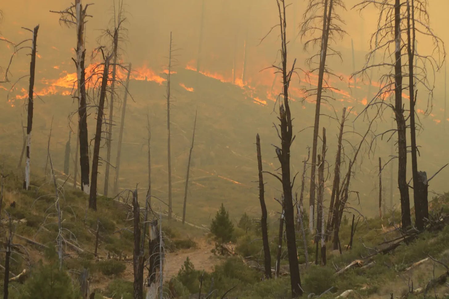
𝗦𝗔𝗟𝗧 𝗖𝗥𝗘𝗘𝗞 𝗙𝗜𝗥𝗘 𝟭𝟬𝟬% 𝗖𝗢𝗡𝗧𝗔𝗜𝗡𝗘𝗗, 𝟭𝟳 𝗟𝗜𝗚𝗛𝗧𝗡𝗜𝗡𝗚-𝗖𝗔𝗨𝗦𝗘𝗗 𝗙𝗜𝗥𝗘𝗦 𝗔𝗟𝗟 𝗦𝗧𝗢𝗣𝗣𝗘𝗗 𝗔𝗧 𝗨𝗡𝗗𝗘𝗥 𝟭𝟬 𝗔𝗖𝗥𝗘𝗦 𝗜𝗡 𝗔 𝗪𝗘𝗘𝗞
Firefighters are completing the last portions of mop-up operations on two of the 17 lightning-caused fires that were found on Oregon Department of Forestry Southwest Oregon District and Bureau of Land Management (BLM) land within the last week, following numerous rounds of thunderstorms that moved through southern Oregon. Between July 15 and 22, five fires were reported on the ODF Medford Unit and 12 were reported on the Grants Pass Unit, all as a result of lightning. At this time, all are 100% contained but two, which are nearly mopped up. A list of lightning-caused fires by date, name, location, size and current status is available below.
Thunderstorms first materialized on the evening of Monday, July 15, with a total of 66 lightning strikes recorded across the district. From this storm, firefighters responded to 13 fires, along with numerous other reports of smoke or fire that were not found to be present. Of these 13 fires, the largest, the Waters Gulch Fire, was stopped at just two acres. The next storm system arrived late Saturday night on July 20, with 18 recorded lightning strikes across both Jackson and Josephine Counties. Four fires were reported, two in each unit. This storm arrived with little to no rain, which allowed for more natural fire growth. Despite this, the largest fire from this group, the Sugarpine Gulch Fire, was caught at just over seven acres. Today, it is 100% lined and 100% mopped up.
These results are largely due to the aggressive initial attack that took place on each fire, as well as partnerships with local agencies, ranging from local structural departments to our federal partners at the BLM and U.S. Forest Service- Rogue River-Siskiyou National Forest; the preparation of all agencies and the readiness to respond to new fire starts is largely contributed to the success on the ground.
Resources and equipment were also strategically used from the Salt Creek Fire, which was caught and lined at just over 4,100 acres and nearly entirely mopped up within the week and a half that the Oregon Department of Forestry Incident Management Team 1 was in command of it. As progress was quickly made on this incident, resources were available to respond to new fire starts and staff lightning-caused fires, even as the Salt Creek Fire transitioned to local control once more. Despite this pull on resources throughout its duration, the Salt Creek Fire is now 100% contained.
In the coming days, additional lightning-caused fires from these storms may surface. ODF Detection Center staff continues to monitor lightning strike areas and firefighters are keeping an eye on strike zones daily within their patrol areas. Reconnaissance flights will be conducted as needed. While these fires can’t be prevented, human-caused wildfires can be; the fire danger level in Jackson and Josephine Counties is extreme and the Industrial Fire Precaution Level is 3. Help firefighters by following all current regulations to prevent human-caused fires.

More information is available here:
• The ODF Southwest Oregon District: https://swofire.com/
• The BLM OR/WA Fire Management Page: https://www.blm.gov/orwafire
BLM-managed lands in the area of the Salt Creek Fire remain closed for safety. For more info go to: https://www.blm.gov/orwafire

𝗦𝘁𝗮𝘆 𝗦𝗮𝗳𝗲 𝗗𝘂𝗿𝗶𝗻𝗴 𝗦𝗺𝗼𝗸𝘆 𝗪𝗲𝗮𝘁𝗵𝗲𝗿!  We’re seeing smoky conditions in our area as a result of fires in the region, so here are some resources to help you stay informed and safe:
Shooting Incident in Grants Pass – On July 19, 2024, at about 9:19 PM, Dispatch received multiple emergency calls of a shooting that just occurred in the 1400 block of Rogue River Highway. Additionally, a male victim was in the parking lot of the apartment complex. Grants Pass Police responded to the scene, along with Oregon State Troopers and Josephine County Sheriff Deputies.
Upon arrival, law enforcement personnel located and provided immediate medical care to a male gunshot victim. Grants Pass Fire/Rescue and AMR paramedics also provided medical care, however the male succumbed to his injuries.
Grants Pass Police Detectives took over the investigation and identified the deceased as Jose Regalado, a 24-year-old male of Grants Pass. Additionally, the OSP major crimes team, Josephine County District Attorney’s Office, and Josephine County Medical Examiner supported the investigation.
This is an active investigation, and we are requesting anyone with information or video to contact the Grants Pass Police Department at 541-450-6260 and reference case number is 2024-26283.
𝗝𝗼𝗶𝗻𝘁 𝗦𝘁𝗮𝘁𝗲𝗺𝗲𝗻𝘁 𝗳𝗿𝗼𝗺 𝗠𝗲𝗱𝗳𝗼𝗿𝗱 𝗦𝗰𝗵𝗼𝗼𝗹 𝗗𝗶𝘀𝘁𝗿𝗶𝗰𝘁 𝗮𝗻𝗱 𝗠𝗲𝗱𝗳𝗼𝗿𝗱 𝗣𝗼𝗹𝗶𝗰𝗲 𝗗𝗲𝗽𝗮𝗿𝘁𝗺𝗲𝗻𝘁:

We continue to be aware of Facebook rumors circulating about the transfer of Officer Josh Doney from the School Resource Officer (SRO) position at South back to patrol. A new SRO has been assigned for South and will be announced soon. Officer Doney’s reassignment to Patrol was not disciplinary. We want to reiterate it is common for officers to be reassigned to different areas within the department.
The rumors that Officer Doney was transferred from SRO back to patrol because he voiced safety concerns that the district and the police department did not want to address are not true. Contrary to false allegations circulating on social media, the Medford Police Department and the Medford School District are leaders in responding to potential threats to students and staff.
It takes a community to keep our students safe and there is nothing that matters more to us. MPD and MSD have the longest standing SRO program in the State of Oregon, and conducted the largest community emergency response exercise in state history last summer. We also recently expanded the program to include several school marshals shared between our MSD elementary schools. The Medford Police Department and the Medford School District make every decision based first and foremost on the safety and security of students and staff and our community.
Allowing false rumors to spread undermines the positive safety impact that the School Resource Officer and School Marshals programs have in our community.
Thank you for supporting the Medford Police and Medford School District 549C as we continue to do everything we can to keep our community safe. -𝘾𝙝𝙞𝙚𝙛 𝙄𝙫𝙚𝙣𝙨, 𝙈𝙚𝙙𝙛𝙤𝙧𝙙 𝙋𝙤𝙡𝙞𝙘𝙚 𝘾𝙝𝙞𝙚𝙛, 𝙖𝙣𝙙 𝘽𝙧𝙚𝙩 𝘾𝙝𝙖𝙢𝙥𝙞𝙤𝙣, 𝙈𝙚𝙙𝙛𝙤𝙧𝙙 𝙎𝙘𝙝𝙤𝙤𝙡 𝘿𝙞𝙨𝙩𝙧𝙞𝙘𝙩 𝙎𝙪𝙥𝙚𝙧𝙞𝙣𝙩𝙚𝙣𝙙𝙚𝙣𝙩
JMET Serves 3 Search Warrants in 2 Days
 JULY 17, 2024 – GREENVIEW RD, CAVE JUNCTION
ARRESTED: Alvaro Rodriguez-De La Paz, 28 years-old
Julio Rodriguez-Cardinas, 48 years-old
CHARGES: 1- Unlawful Possession of Marijuana
2- Unlawful Manufacturing of Marijuana
DETAILS: On July 17, 2024, the Josephine Marijuana Enforcement Team (JMET) executed a search warrant in the 800 Block of Greenview Road, Cave Junction, regarding an illegal marijuana grow site. The search warrant was executed with the assistance of the U.S. Forest Service (USFS), Homeland Security Investigations (HSI), and Josephine County Public Health & Building Safety.
During the execution of the warrant, over 3,100 marijuana plants and approximately 2,000 pounds of processed marijuana were seized and destroyed. Additionally, a large amount of cash and 3 firearms were seized on scene.
The property also had multiple electrical, water, and solid waste code violations. These violations could result in the criminal forfeiture of the property.
Alvaro Rodriguez-De La Paz and Julio Rodriguez Cardenas were both taken into custody and lodged in the Josephine County Jail for Unlawful Possession of Marijuana and Unlawful Manufacturing of Marijuana.
JULY 18, 2024 – CLEAR CREEK RD AND PINE TREE WAY, SELMA
INCIDENT DATE: July 18, 2024
ARRESTED: Rainy Jeanne Gauvain, 51 years-old
CHARGES: 1- Unlawful Possession of Marijuana
2- Unlawful Manufacturing of Marijuana
DETAILS: On July 18, 2024, the Josephine Marijuana Enforcement Team (JMET) with the assistance of Josephine County Public Health & Building Safety, executed a search warrant in the 300 Block of Clear Creek Road, Selma, regarding an illegal marijuana grow site.
During the execution of the warrant, over 1,400 marijuana plants were seized and destroyed. Additionally, a large amount of cash and 2 firearms were seized on scene.
The property also had multiple electrical, water, and solid waste code violations. These violations could result in the criminal forfeiture of the property.
While investigators were on scene, they discovered a second illegal marijuana grow site nearby on Pine Tree Way. Detectives subsequently wrote and executed another search warrant, yielding over 590 marijuana plants that were seized and destroyed. The responsible party is known at this time and charges will be referred to the District Attorney’s Office.
Rainy Jeanne Gauvain was taken into custody and lodged in the Josephine County Jail for Unlawful Possession of Marijuana and Unlawful Manufacturing of Marijuana.
At the time of this press release the investigations are ongoing and no further details are being released.
JULY 17, 2024 – GREENVIEW RD, CAVE JUNCTION
ARRESTED: Alvaro Rodriguez-De La Paz, 28 years-old
Julio Rodriguez-Cardinas, 48 years-old
CHARGES: 1- Unlawful Possession of Marijuana
2- Unlawful Manufacturing of Marijuana
DETAILS: On July 17, 2024, the Josephine Marijuana Enforcement Team (JMET) executed a search warrant in the 800 Block of Greenview Road, Cave Junction, regarding an illegal marijuana grow site. The search warrant was executed with the assistance of the U.S. Forest Service (USFS), Homeland Security Investigations (HSI), and Josephine County Public Health & Building Safety.
During the execution of the warrant, over 3,100 marijuana plants and approximately 2,000 pounds of processed marijuana were seized and destroyed. Additionally, a large amount of cash and 3 firearms were seized on scene.
The property also had multiple electrical, water, and solid waste code violations. These violations could result in the criminal forfeiture of the property.
Alvaro Rodriguez-De La Paz and Julio Rodriguez Cardenas were both taken into custody and lodged in the Josephine County Jail for Unlawful Possession of Marijuana and Unlawful Manufacturing of Marijuana.
JULY 18, 2024 – CLEAR CREEK RD AND PINE TREE WAY, SELMA
INCIDENT DATE: July 18, 2024
ARRESTED: Rainy Jeanne Gauvain, 51 years-old
CHARGES: 1- Unlawful Possession of Marijuana
2- Unlawful Manufacturing of Marijuana
DETAILS: On July 18, 2024, the Josephine Marijuana Enforcement Team (JMET) with the assistance of Josephine County Public Health & Building Safety, executed a search warrant in the 300 Block of Clear Creek Road, Selma, regarding an illegal marijuana grow site.
During the execution of the warrant, over 1,400 marijuana plants were seized and destroyed. Additionally, a large amount of cash and 2 firearms were seized on scene.
The property also had multiple electrical, water, and solid waste code violations. These violations could result in the criminal forfeiture of the property.
While investigators were on scene, they discovered a second illegal marijuana grow site nearby on Pine Tree Way. Detectives subsequently wrote and executed another search warrant, yielding over 590 marijuana plants that were seized and destroyed. The responsible party is known at this time and charges will be referred to the District Attorney’s Office.
Rainy Jeanne Gauvain was taken into custody and lodged in the Josephine County Jail for Unlawful Possession of Marijuana and Unlawful Manufacturing of Marijuana.
At the time of this press release the investigations are ongoing and no further details are being released.
𝗦𝘁𝗮𝘆 𝗣𝗿𝗲𝗽𝗮𝗿𝗲𝗱! Fire season is in full swing, and we have several resources designed to help keep you and your loved ones safe:
Southern Oregon Property Insurance Sees Massive Shifts Following Wildfires
Facing a new era of risk in the light of climate-driven wildfires, insurers and residents are battling to adapt, with rural property owners facing the brunt of the changing world as insurance rates go up or in some cases- property owners struggle to get cover. Since the 2020 Labor Day fires destroyed parts of the state- with nearly $3 billion in losses, property owners across Southern Oregon have faced an ongoing flow of communications from insurance companies- whether it’s increases, a threat to cancel, or difficulty finding insurance, according to state Rep. Pam Marsh, a Democrat, representing southern Jackson County.National Insurance Shake-up As Natural Disasters Eat Into Profits
Published in May, a New York Times investigation showed that homeowners insurance was unprofitable in 18 states in 2023. This prompted insurers to raise premiums, cancel policies, or completely leave states. Driven mainly by natural disasters related to climate change such as wildfires in the western states, hurricanes in Florida, and major storms and flooding in the Midwest, as climate change escalates, insurers- who carry the weight of the disasters, are experiencing more pressure. Without insurance, homeowners won’t be able to get a mortgage. This could result in a domino effect, with declining property values reducing tax revenues across counties- funding vital for schools and other essential services. California is experiencing a crisis as companies like Allstate and Farmers Direct are not underwriting new policies or renewing existing ones in reaction to legislation that made it difficult, if not impossible, to stay profitable. California insurers can’t raise rates more than 10% without a lengthy review process and are also prohibited from using “catastrophe modeling” to predict disasters such as wildfires and storms when setting insurance rates. Many of the industry’s largest companies responded by simply leaving the state. Russ Schweikert, a partner at Ashland Insurance said, “The good news in Oregon is that we’re not California”
Attention Dog Lovers: Jackson County Sheriff Search & Rescue Looking for K9 Handlers

Jackson County Sheriff’s Office (JCSO) Search and Rescue (SAR) is recruiting prospective K9 handlers. JCSO SAR is looking for dog lovers willing to become K9 search team members. This volunteer opportunity is demanding but also greatly rewarding. K9 teams are called upon frequently for missions and are often the first searchers on the scene.
K9 teams can be trained and certified in several disciplines: wilderness area search, trailing, human remains detection, and article location. Initial training and certification can take 18 months or more.
Anyone thinking of becoming a SAR K9 handler needs to be fully aware of the significant time and financial commitment involved. The K9 team trains twice a week (Wednesday evening and Saturday morning). The training location can be nearly anywhere in Jackson County.
Prospective handlers need to own a dog that can work. The dog should be two years old or younger but that can be negotiated. Handlers must be physically fit and be comfortable with technology (radios, GPS, cellphones). Handlers must also have a reliable vehicle capable of safely transporting their dog.
Any prospective handler will first have to volunteer with SAR and complete the training academy. Before joining any SAR special team, volunteers must complete a six-month training period.
The next deadline for SAR applications is August 1, 2024. The application can be found at https://www.jacksoncountyor.gov/departments/sheriff/divisions/search_and_rescue/index.php
If you think you are up to the challenge, contact jcso.sar.k9team@gmail.com for more information.
VOTE for Ashland’s Winchester Inn Nominated by USA Today as a 2024 Best Wine Country Hotel
Decades before Wine Enthusiast magazine included southern Oregon’s Rogue Valley as one of the 2022 top five wine regions in the world, the Winchester Inn in Ashland had been celebrating regional vintners and catering to people who travel here to savor award-winning red, white and sparkling wines.
Now, the Winchester Inn has been nominated by USA Today as a 2024 Best Wine Country Hotel. Nominees are selected by a panel of experts and voting by the public continues until 9 a.m. July 22.
Vote for The Winchester Inn
Best Wine Country Hotel — The Winchester Inn in Ashland, Oregon, offers a boutique hotel experience that combines comfort and charm, including a gourmet breakfast served each morning as part of the stay. Situated in downtown Ashland, the inn offers convenient access to nearby wineries, outdoor activities such as hiking and biking, and the renowned Oregon Shakespeare Festival.
Hearts with a Mission, a program to help local seniors who need assistance, is seeking volunteers.
The volunteer-based program — which started in January 2023 — has 90 volunteers ready to help, but more than 100 seniors who need assistance. Stephanie Miller, the Hearts For Seniors Program Manager, said that it’s a heartwarming job and fulfilling volunteer work. Residents can apply here.
David Grubbs’ Murder Investigation Remains Active
 The Ashland Police Department’s investigation into the murder of David Grubbs on November 19, 2011 remains open and active. Recently two new detectives have been assigned to look into new leads that have come in.
This case remains important to David’s family, the community, and the Ashland Police Department. As detectives continue to pursue these new leads, anyone with additional information is encouraged to reach out to the Ashland Police Department at 541-488-2211. The reward for information leading to an arrest on this case remains at over $21,000.
It has been Four Years since Fauna Frey, 45, disappeared in Oregon on a road trip, June 29, 2020, following her brother’s death —
PART 2 – Newsweek Podcast Focusing on The Disappearance of Fauna Frey From Lane County

Help Find Fauna Frey #FindFaunaFrey FACEBOOK GROUP

Oregon Department of Transportation – If you plan to travel across the state in the coming days, make sure you carefully plan your route.

Campfires temporarily banned at most Oregon State Parks due to dry conditions, nearby wildfires

- Several parks have been closed due to wildfires including Battle Mountain Forest State Scenic Corridor, Farewell Bend State Recreation Area, East and West Hatfield Trailheads on the Columbia River Highway State Trail and Ukiah-Dale Forest State Scenic Corridor. Check park webpages at stateparks.oregon.gov/ and search by park.
- Some parks have reduced air quality due to wildfire smoke. Check DEQ’s website for air quality information at www.oregonsmoke.org/
- Several roads and highways have been closed due to wildfires. Please use TripCheck to learn about closures and alternative routes. Relying on GPS might lead drivers into unsafe conditions
Campfires prohibited across BLM’s Northwest Oregon District
– Starting July 23, campfires will be prohibited on all Bureau of Land Management public lands throughout the Northwest Oregon District. BLM leaders encourage all visitors to be aware of active restrictions and closures as hotter, drier weather sets in around the Pacific Northwest. In addition to fires and campfires, the stronger restrictions also prohibit smoking in vegetated areas; using vehicles in unmanaged vegetated areas; operating a chainsaw; welding, cutting or grinding; or using an internal combustion engine without a spark arrestor. These prohibitions will stay in effect until rescinded. These level II fire restrictions help reduce the risk of human-caused fires. They build on the BLM’s statewide fire restrictions prohibiting fireworks, exploding targets or metallic targets, steel component ammunition (core or jacket), tracer or incendiary devices, and sky lanterns, which went effect May 24. Those who violate the prohibition may be fined up to $100,000 and/or imprisoned for up to 12 months. In addition, those found responsible for starting wildland fires on federal lands can be billed for the cost of fire suppression. For the complete order and more information on seasonal fire restrictions and fire closures, please see www.blm.gov/orwafire. To learn more about fire careers with BLM Oregon-Washington, please see https://www.blm.gov/programs/public-safety-and-fire/fire/state-info/oregon-washington/careers.Oregon Investigators Offering Reward For Information Identifying Individuals Who Started The 134,000 Acre Cow Valley Fire
Reward offered for information relating to wildfires in the Malheur Reservoir area.
VALE, Ore. – Fire investigators and law enforcement officials are requesting the public’s assistance in the investigation of the Cow Valley, Bonita and other small wildfires in the Malheur Reservoir area. These fires all began in the early morning hours of July 11, between approximately 1 and 5 a.m. They are believed to be human-caused and of a suspicious nature. A monetary reward is being offered for information leading to the identification of individuals responsible. Anyone with information about any of these incidents should call We Tip Anonymous at 1-800-47-ARSON, online at wetip.com. This is a multi-agency investigation by the Bureau of Land Management Vale District, Oregon State Fire Marshal, Malheur County Sheriff’s Office, and Oregon State Police. Shortly after these and other fires broke out, the Pacific Northwest increased its wildfire preparedness to the highest level, a PL5. There are currently 28 uncontained large fires in the PNW, with 11 Teams assigned to these incidents. (SOURCE)Elevated wildfire risk as Oregon wildfire season off to ‘aggressive start’
A spate of lightning storms coupled with hot dry weather has created high-risk wildfire conditions earlier than expected, officials said
Heat, lightning and wind have conspired to create high-risk conditions for wildfire across southern, central and eastern Oregon far earlier in the summer than state officials anticipated. “We are fighting fire like it’s August 19, not July 19,” said Mariana Ruiz-Temple, Oregon’s state fire marshal, at a news conference Friday. The wildfire season in the Northwest can last from May through October, but typically the season is most intense from July to September. As of Friday afternoon, there were 24 large fires of 100 or more acres burning in parts of Oregon, according to the Northwest Interagency Coordination Center, a wildfire prevention and response network that includes nine state and federal agencies across the West.Statewide emergency
On July 12, Kotek declared a statewide wildfire emergency, which enabled National Guard deployment to parts of the state and allowed state and federal resources to flow to areas in need. “To be very honest, our wildfire season is off to a very aggressive start,” she said. Oregon has received additional equipment and firefighters from Washington, California, New Mexico, Idaho, Montana, Oklahoma, Texas, Georgia, Colorado and Florida, and Kotek expects more wildfire fighters will arrive in the coming days. “I cannot emphasize enough: This is a dynamic, fast-moving situation for our state, and we will continue to use every resource, every person that we can get our hands on, to fight these fires,” she said.For more information on how to prepare for possible evacuation, visit: wildfire.oregon.gov Kotek could not provide details about whether or not the state would exceed its emergency wildfire budget, but indicated costs are adding up. “I can say, it will be more expensive than the last fire season. I think that’s a safe bet,” she said. Global issues with CrowdStrike security software taking down Microsoft systems has not impacted the agency’s work or any wildfire response work in Oregon, Kotek said. Teams from the Oregon State Fire Marshal’s Office, Department of Forestry and the U.S. Forest Service and Bureau of Land Management are working together to protect property and natural resources. Erin McMahon, director of the Department of Emergency Management, said there have been 88 evacuation orders across the state so far this summer. “Our firefighters are working at all hours of the day and night, in conditions that are hard for many of us to fathom,” Kotek said. “It’s going to be a long wildfire season, and we need each and every one of them.” (SOURCE)Monitoring Fires in Oregon

| Incident | Type | State | Incident Size | UpdatedSort ascending |
|---|---|---|---|---|
| Oakridge Lightning Fires 2024 – ORWIF | Wildfire | Oregon | Acres | 3 minutes 26 seconds ago |
| Red Fire – ORDEF | Wildfire | Oregon | 262 Acres | 23 minutes 21 seconds ago |
| Boneyard Fire – OR95S | Wildfire | Oregon | 39646 Acres | 25 minutes 26 seconds ago |
| Diamond Complex – ORUPF | Wildfire | Oregon | 3352 Acres | 28 minutes 25 seconds ago |
| Durkee Fire – ORVAD | Wildfire | Oregon | 244842 Acres | 40 minutes 33 seconds ago |
| Lone Rock Fire – ORPRD | Wildfire | Oregon | 134752 Acres | 1 hour 2 minutes ago |
| Cow Valley Fire – ORVAD | Wildfire | Oregon | 133490 Acres | 9 hours 9 minutes ago |
| Battle Mountain Complex – OR97S | Wildfire | Oregon | 52832 Acres | 9 hours 32 minutes ago |
| Cottage Grove – Lane 1 – OR77S | Wildfire | Oregon | 1090 Acres | 10 hours 7 minutes ago |
| Homestead Complex – ORUPF | Wildfire | Oregon | 767 Acres | 10 hours 7 minutes ago |
| Ore Fire – ORWIF | Wildfire | Oregon | 747 Acres | 10 hours 12 minutes ago |
| Telephone Fire – ORMAF | Wildfire | Oregon | 5000 Acres | 11 hours 49 minutes ago |
| Whisky Creek Fire – ORMHF | Wildfire | Oregon | 155 Acres | 11 hours 49 minutes ago |
| Falls Fire – ORMAF | Wildfire | Oregon | 139507 Acres | 12 hours 2 minutes ago |
| Pyramid Fire – ORWIF | Wildfire | Oregon | 535 Acres | 12 hours 24 minutes ago |
| Microwave Tower – OR954S | Wildfire | Oregon | 150 Acres | 13 hours 33 minutes ago |
| Salt Creek – OR710S | Wildfire | Oregon | 4102 Acres | 1 day 15 hours ago |
| Larch Creek Fire – OR95S | Wildfire | Oregon | 18286 Acres | 4 days 9 hours ago |
| Little Yamsay Fire – ORFWF | Wildfire | Oregon | 6340 Acres | 1 month 3 weeks ago |
| 2023 Chilcoot Fire UNF – ORUPF | Wildfire | Oregon | 1940 Acres | 2 months ago |
| 2023 Chilcoot Fire UNF – ORUPF | Wildfire | Oregon | 1940 Acres | 2 months ago |
| 2023 Ridge Fire UNF – ORUPF | Wildfire | Oregon | 214 Acres | 2 months ago |
| 2023 Ridge Fire UNF – ORUPF | Wildfire | Oregon | 214 Acres | 2 months ago |

Please Help Prevent Wildfires!
In these dry conditions, a single spark can cause a lot of damage. Learn how you can prevent wildfires by visiting the Oregon State Fire Marshal’s wildfire prevention page.

Climate change a growing public health threat in Oregon, but state adapting, report finds
The latest Climate and Health in Oregon report shows health impacts of heat, smoke and drought are rising, but some state investments are paying off
More Oregonians are suffering from respiratory, heart and mental health issues caused by extreme weather events linked to climate change, and rural, elderly and minority communities are being hit the hardest, a new state report found.
Hottest year on record
Globally, 2023 was the hottest year on record, though Oregon was spared from exceptional wildfire events like those in 2020 and the excessive heat events like the summer “heat dome” in 2021, when temperatures reached triple digits from late June through mid-July. The Oregon Health Authority had not anticipated an event like that in the Portland metro area until 2050, the report said. Between 2020 and 2023, 139 people died from heat-related causes in Oregon, including more than 100 in 2021. The toll over those years was three times that of the previous decade. Cardiovascular disease contributed to 25% of those deaths, and people 50 and older accounted for 87%, the report said. It also looked at the lasting impacts of the 2020 wildfire season and 2021 heat dome. The 2020 Labor Day fires burned more than 1 million acres, destroyed 5,000 homes, largely destroying the towns of Gates, Detroit, Phoenix and Talent, and left nine people dead. Researchers found that mental health suffering, including uncontrollable worry, was acute among wildfire survivors years after the events. Officials said making communities resilient to climate change and adapting to heat and wildfire need to be baked into recovery and rebuilding efforts after such events. The report said health authority officials are working on reaching people from different demographics in different parts of the state. Surveys have found that older Oregonians prefer to be alerted to upcoming extreme weather events through local television, while most other Oregonians prefer text messages. But more resources are needed, especially to help households obtain filters, emergency supplies for wildfires and upgraded doors and windows so they fully seal. (SOURCE)Avangrid hires 5,000 sheep for grazing on two solar projects in the Pacific Northwest
Avangrid, member of the Iberdrola Group, has partnered with a fifth-generation Oregon rancher to graze sheep at two solar farms in Oregon and Washington, and launched likely the largest “solar grazing” operation in the region. Solar grazing is a vegetation management method used at solar energy facilities that uses grazing livestock, like sheep, instead of machinery. Sheep are effective at limiting the growth of weeds and vegetation, cutting down on wildfire risks while replacing the use of gas-powered machines.
U.S. Senators Ron Wyden and Jeff Merkley and Representative Val Hoyle announced $16.6 million in federal funds for Oregon habitat restoration and coastal resilience projects have been made available through the Bipartisan Infrastructure Law and Inflation Reduction Act.
Wyden said, “Salmon, fishing and our beautiful outdoors are all central to Oregon’s economy and identity”. Wyden said, “This funding is exactly what I fought for in the Bipartisan Infrastructure Law and the Inflation Reduction Act, and I will continue to advocate for more resources to preserve Oregon’s pristine waterways and coast”. Merkley said, “Oregon’s native fish are the lifeblood of our state, supporting the health and vitality of our communities, local economies, and Tribes who have been here since time immemorial”. Merkley said, “…Crucially, the two projects receiving funding will strengthen coastal resiliency and go a long way to enhance habitat for fish populations, including our beloved coho salmon, spring Chinook salmon and other native fish species”. Hoyle said, “It will support better habitats for salmon on the Willamette River and the Oregon Coast. I’m looking forward to seeing the results of these investments, and I’ll continue working to bring federal funding back to Oregon”. The joint release said the $16.6 million comes from the National Oceanic and Atmospheric Administration Fisheries’ Office of Habitat Restoration and will be used for: *McKenzie Watershed Alliance – Resilience through Floodplain Restoration: Creating Conditions for Native Species and Communities to Thrive in the Upper Willamette: $8.5 million. *Wild Salmon Center – Oregon Coast Coho Recovery Plan Implementation in Oregon: $8.1 million.Opioid Settlement Board directs $13 million to substance use disorder treatment infrastructure
State Alcohol and Drug Policy Commission recommended allocation, which OHA will administer PORTLAND, Ore. – A $13.08 million allocation by the Opioid Settlement Prevention, Treatment & Recovery Board (Settlement Board) will expand and strengthen the state’s access to substance use disorder treatment and services through opioid treatment programs (OTPs) and jails. The Board approved Alcohol and Drug Policy Commission (ADPC) recommendations July 10. The allocation, which Oregon Health Authority (OHA) will administer, will improve access to medication for opioid use disorder and treatment services by providing:- Up to $3.9 million to fund:
- Two mobile or non-mobile medication units in Clackamas County serving Oregon City and rural Clackamas County.
- An opioid treatment program or a mobile or non-mobile medication unit in Multnomah County serving the geographic areas of the county with the highest unmet need.
- Up to $9.1 million to fund a total of seven opioid treatment programs or mobile or non-mobile medication units, specifically:
- Two in Northeastern Oregon.
- One in the Mid-Gorge region.
- One in Klamath County.
- Two in underserved coastal areas.
- One in eastern Lane County.
- Up to $250,000 to Oregon Health & Science University (OHSU) to provide technical assistance to jails and to foster collaboration between opioid treatment providers and jails.
Oregon Wildlife Agencies Want Your Help Tracking Roadkill
This summer, the Oregon Department of Fish and Wildlife and the Oregon Zoo started asking Oregonians to do their own tracking and upload pictures of roadkill.
Sens. Merkley and Wyden and Rep. Blumenauer urge VA to expand care to medical cannabis
They say that the prohibition deprives veterans of a drug that’s legal in nearly 40 states and forces them go to outside the VA system
U.S. Sen. Jeff Merkley wants veterans to receive access to medical cannabis through Veterans Affairs clinics and hospitals. Merkley, D-Oregon, led a left-leaning independent and seven other Democratic senators, including Oregon’s U.S. Sen. Ron Wyden, in sending a letter late last week to Veterans Affairs Secretary Denis McDonough, urging him to allow medical marijuana treatment for veterans in states that have legalized its use. Medical cannabis is legal in nearly 40 states and the District of Columbia, but the federal government has not changed it alongside that trend. The letter follows a similar plea in June spearheaded by another Democratic Oregon congressional member, Rep. Earl Blumenauer, co-chair of the Congressional Cannabis Caucus. Oregon is home to 250,000 veterans and many rely on U.S. Department of Veterans Administration outpatient clinics in urban and rural communities and its hospitals in Portland and Roseburg. But a VA directive bars providers from recommending the use of medical marijuana or making referrals for its use. It even prevents providers from completing forms for state-authorized medical marijuana. But advocates are hopeful the VA will loosen these restrictions following a May proposal by the U.S. Drug Enforcement Administration. It recommended that marijuana be rescheduled from Schedule 1 – the most restrictive listing possible for dangerous drugs with no recognized medical use – to Schedule III, which is less restrictive and recognizes the medical benefits of cannabis, potentially opening up treatment options. The senators asked the VA to educate providers about the benefits of cannabis use to treat various medical conditions, including anxiety and seizures. They noted that scientific data shows it’s effective for controlling nausea and vomiting and stimulating the appetite while being much less addictive than opioids in treating pain. “Leaving our nation’s heroes without access to effective pain management methods is unconscionable,” the letter said. Blumenauer’s letter struck a similar tone, saying that barring medical marijuana forces veterans to seek outside care. “No one is better qualified to make recommendations on care for veterans than veterans working with their VA health care providers,” Blumenauer wrote. “Placing arbitrary restrictions on those decisions is a disservice to our veterans.” The letter was signed by a Republican, Rep. David Joyce of Ohio, and a Democrat, Rep. Barbara Lee of California. In June, with a boost from Blumenauer, the House voted to 290-116 to pass an amendment to the VA’s spending bill that would end the agency’s prohibition on helping veterans access medical marijuana care. The bipartisan amendment, co-sponsored with U.S. Rep. Brian Mast, R-Florida, would require the agency to authorize providers to discuss medical marijuana with veterans and recommend that care if they believe it is necessary. In 1998, Oregon voters approved legalizing medical marijuana. In 2014, Oregon voters legalized recreational marijuana. Besides Merkley and Wyden, Democratic Sens. Kirsten Gillibrand of New York; Elizabeth Warren of Massachusetts; John Fetterman of Pennsylvania; Peter Welch of Vermont; Tina Smith of Minnesota; and Jacky Rosen of Nevada signed the letter along with Sen. Bernie Sanders, an independent from Vermont who caucuses with Democrats. (SOURCE)Recently timeout.com listed the best parks in the United States and Oregon was the only state in the Northwest that made it to the top 10.

Bags of rice recalled in seven US states as they may contain ‘rodent parts’
Wehah Farms has issued a recall of 4,600 cases of its Lundberg Family Farms Sustainable Wild Blend Gourmet Rice in seven states . This is due to the potential presence of a “foreign object that appears to be of rodent origin.”
The Oregon Coast Aquarium New Tufted Puffin Oregon License Plates on Sale
One of Oregon’s most adorably iconic seabirds is coming to the front and back of a car near you. The Oregon Coast Aquarium has opened voucher sales for its new tufted puffin license plates.


