
The latest news stories of interest in the Rogue Valley and the state of Oregon from the digital home of Southern Oregon, Wynne Broadcasting’s RogueValleyMagazine.com
Monday, July 20, 2026
Rogue Valley Weather

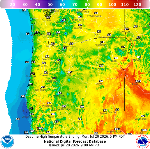
https://graphical.weather.gov/sectors/oregon.php
 https://graphical.weather.gov/sectors/oregon.php
Oregon now has more than 60 active wildfires burning, along with two large fire complexes, and it’s only July.
Hot weather is in the forecast this week, with temperatures in the high 90s and reaching 100s. As you enjoy the sunshine, remember to drink plenty of water, apply sunscreen, and take breaks in the shade during the hottest part of the day. If you have pets, make sure they have plenty of fresh water and a cool place to rest. It is also a good time to check in on neighbors, family members, or friends who may need a little extra support during the heat. Have a safe and happy week!

East Evans Creek Fire – Jackson County
There are several highways and various roads being impacted by the fires burning locally and in the region.
We want to urge motorists in the area, as well as those planning to travel through the area, to look at www.tripcheck.com before they leave.
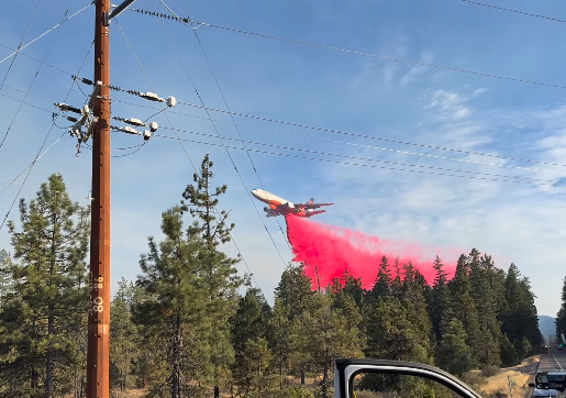
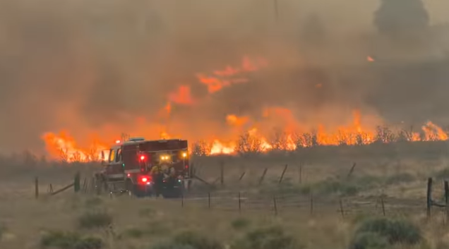
Slow down, turn on your headlights, remain alert for fire vehicles and apparatus, and keep and eye out for signage indicating increased firefighting activity.
Conditons remain hot and dry with fire spreading through dry grasses and herbaceous fuels. Reminder to visit tripcheck.com, and thank you in advance for keeping yourself and everyone safe.

East Evans Creek Fire – Jackson County –
East Evans Creek fire is now 15,015 acres.
Operations Section Chiefs Kyle Gibbons and Mark Corless provide a morning update on the East Evans Creek Fire for Monday, July 20, 2026. REEL: facebook.com/reel/27213945654954492/?s=single_unit
𝙀𝘼𝙎𝙏 𝙀𝙑𝘼𝙉𝙎 𝘾𝙍𝙀𝙀𝙆 𝙁𝙄𝙍𝙀 𝘼𝙈 𝙐𝙋𝘿𝘼𝙏𝙀: Firefighters complete line around active portion of Board Mountain spot fire, progress continues today


SAMS VALLEY, Ore. – Overnight, firefighters on the East Evans Creek Fire continued to make steady progress across the incident. Crews pushed mop-up operations deeper into the fire’s interior and strengthened control lines. Extensive structure preparation and protection measures have been completed around threatened communities.
Resources on the Board Mountain spot fire strengthened existing control lines, including the southwestern edge where the fire crossed the fireline late yesterday. Overnight, crews focused on the southern portion of the fire south of Boswell Mountain to reinforce the perimeter and limit additional spread. Operations today will continue to surge on the southern portion of the Board Mountain spot fire, focusing on improving the line, mop-up and felling trees to reduce overhead hazards. Structural resources remain positioned near homes in the Antioch, Jones Road, and Pomeroy areas, as well as in the Shady Cove, Trail, Long Branch, and Dry Creek communities, as part of a proactive structure protection strategy while supporting wildland operations. Structural resources bolstered suppression efforts and patrolled areas near homes, checking for hot spots.
Across the main fire, control lines held, and firefighters remained vigilant as dry vegetation and persistent heat continues to support elevated spotting potential. Crews also held the Canyon Creek spot fire within its existing footprint overnight and continued working adjacent to the fireline to secure the perimeter on the spot fire northwest of Hull Mountain. Firefighters will continue extending hose lays to support deeper mop-up operations, while structural crews maintain a presence in the Ramsey Canyon Road area and continue providing high-capacity pump support to increase water delivery for wildland operations. Crews today will again be available for repositioning to bolster other areas of the fire or to support initial attack with local agencies. Structure protection resources remain in place in the Shady Cove, Trail, Canyon Road, Dry Creek, and other nearby areas holding the lines.
An incident meteorologist is on scene monitoring conditions including cloud cover, which can delay the lift of the inversion. Although morning temperatures are cooler and isolated showers have been observed, winds are expected to pick up again in the afternoon, and temperatures may reach the mid- to high-90s. Dry fuels, steep terrain, and shifting winds remain factors that could challenge containment efforts later in the day, and spotting potential continues to be elevated. With strengthened lines, overnight cooling, and coordinated support across the incident, firefighters enter the day positioned to build on yesterday’s progress while remaining alert to potentially increased fire activity as conditions shift.
Aircraft today will work with ground resources to address hot spots and support firefighters as they work to tighten the southeast side of the Board Mountain spot fire, where crews and initial dozer line stopped forward movement overnight. Structural tenders will continue supporting water delivery to helicopter dip sites, as needed, to sustain aerial suppression operations.
Evacuations: There are evacuations in place in both Jackson and Douglas counties, issued by both counties’ Sheriff’s Offices and Emergency Management. Up-to-date evacuations are available here: https://readyjacksonco.com/…/emergency-information-hub…
Find your evacuation zone here: https://tinyurl.com/EastEvansCreekFireEvacMap
Road/Land Closures: Traffic is closed to the public on East Evans Creek Road at Meadows Road. The BLM has issued a road closure for West Fork Evans Creek Road and Rock Creek Road. Please avoid the fire area to allow firefighters and heavy equipment to operate safely. Road closure information is available on https://tripcheck.com/
A closure order for BLM-administered lands near the East Evans Creek Fire is in place. Public entry, including hunting, hiking, and camping, is prohibited. More information about the closure, including a map, is available online at www.blm.gov/orwafire
Smoke Impacts: Smoke from the East Evans Creek Fire may settle into valleys and other low-lying areas, reducing visibility and impacting air quality in nearby communities. Smoke conditions can change throughout the day as winds shift. Individuals sensitive to smoke should take appropriate precautions. For current air quality information and smoke forecasts, visit: https://fire.airnow.gov/
Temporary Flight Restriction (TFR): A “TFR” is in place for the fire area daily (24 hours) until further notice. Complete information is available at https://tfr.faa.gov/tfr3/?page=detail_6_4915
Flying a drone near or around a wildfire is illegal, compromises the safety of both pilots and firefighters, and interferes with firefighting efforts.
Cause: The fire started on Friday, July 10th at 2:41 p.m. after a car crashed into a power pole, sparking dry vegetation in the area. The Jackson County Sheriff’s Office is currently investigating the cause of the crash.
𝙒𝘼𝙇𝘿𝙊 𝘼𝙉𝘿 𝙍𝙄𝘿𝙂𝙀 𝙑𝙄𝙎𝙏𝘼 𝙁𝙄𝙍𝙀𝙎 (Josephine County) 𝘼𝙈 𝙐𝙋𝘿𝘼𝙏𝙀: Firefighters gained significant ground overnight on both the Waldo and Ridge Vista fires, building on yesterday evening’s aggressive initial attack.
Overnight humidity recoveries gave crews favorable conditions to reinforce containment lines and make excellent headway ahead of another day of hot, dry weather.

The Waldo Fire has been remapped at just over 30 acres. The updated acreage reflects more accurate overnight mapping and does not indicate overnight fire growth. Firefighters completed dozer line and hose lay around the entire fire overnight, marking a major milestone in suppression efforts.
Today, crews will expand mop-up operations and improve existing containment lines. Resources assigned to the Waldo Fire include three 20-person hand crews, three Type 6 engines, two water tenders, one dozer, one faller module, which specializes in removing hazardous fire-weakened trees. Totaling to approximately 72 people assigned to the fire.
The Ridge Vista Fire remains at 15 acres. Firefighters completed line construction and hose lay around the entire fire overnight and have mopped up approximately 20 feet in from the perimeter. Today’s work will focus on extending mop-up farther into the interior while securing the fire’s edge and extinguishing remaining pockets of heat. Resources assigned to the Ridge Vista Fire include three 20-person hand crews, three Type 6 engines, one water tender, one dozer. Totaling to approximately 70 people assigned to the fire.
Today’s priorities are to keep both fires within their current footprints while crews continue in-depth mop-up. Firefighters will also be working around hazardous fire-weakened trees, known as snags, which create additional challenges and require extra caution. Although a few areas received light raindrops overnight and humidity increased, fuels remain critically dry, and another warm, dry day is expected. Crews will continue securing the fire perimeter while building on the gains made overnight. The official cause of both the Waldo and Ridge Vista fires remains under investigation.
ODF Southwest Oregon District – 𝙋𝙐𝘽𝙇𝙄𝘾 𝙐𝙎𝙀 𝙍𝙀𝙎𝙏𝙍𝙄𝘾𝙏𝙄𝙊𝙉𝙎 𝘿𝙐𝙍𝙄𝙉𝙂 𝙁𝙄𝙍𝙀 𝙎𝙀𝘼𝙎𝙊𝙉
All Oregon Department of Forestry (ODF) districts are in fire season. This means that to reduce the risk of human-caused wildfires, fire restrictions may be in place where you live or at a destination you plan to visit or recreate.
Fatal Boating Incident at Diamond Lake, Divers Recover Body
DIAMOND LAKE, Ore. – On Saturday, July 18, 2026, at approximately 2:17 p.m., the Douglas County Sheriff’s Office responded to Diamond Lake following a report of a person who had fallen overboard from a pontoon boat and disappeared beneath the water.

The victim was identified as 71-year-old William Harry Bailey of Bethalto, Illinois, who was at Diamond Lake with family members for a reunion. Earlier in the day, the family rented a pontoon boat to spend time on the lake.
Deputies learned that Bailey and his sister moved to the bow of the pontoon boat to take a photograh. As they stood at the front of the boat, the bow dipped into the water, causing the stern to rise. Both Bailey and his sister lost their balance and fell into the lake.
Witnesses report Bailey pushed his sister out of the way to prevent her from falling in front of the boat. In doing so, Bailey fell directly in front of the moving pontoon, which passed over him. Bailey briefly resurfaced before going back underwater.
Family members immediately began searching for Bailey and called 911. Deputies, fire personnel and other emergency responders searched the area of the last known point he was seen but were unable to immediately locate him.
Divers from the Douglas County Sheriff’s Office responded and were able to locate and recover Bailey’s body from the lake. The Douglas County Medical Examiner’s Office was notified.
The Douglas County Sheriff’s Office extends its deepest condolences to Mr. Bailey’s family and friends during this difficult time.
Assisting agencies included Diamond Lake Resort, Central Douglas Fire & Rescue, Oregon State Police, Umpqua Valley Ambulance, REACH Air Medical Services and the Oregon State Marine Board.
Recovery of Human Remains — CASE NUMBER: 26-18588
DETAILS: On Thursday, July 16, 2026, around 12:15pm, a member of the Josephine County Search & Rescue (SAR) team was checking along Reuben Mountain beyond the Grave Creek Bridge. Based on observations along the roadside, they suspected human remains were in the area.
Due to lack of cell phone service in the area, the SAR member began driving back towards Merlin to make phone contact with investigators. They came upon Troopers from the Oregon State Police and a Deputy from the Sheriff’s Office at the Galice Resort and relayed their observations.
Troopers and the Deputy responded to the reported area and traversed down the steep, rugged terrain where a deceased person was located.
Detectives from the Oregon State Police, Grants Pass Police Department, Josephine County Sheriff’s Office and District Attorney’s Office then responded to the scene with a rope team from Josephine County SAR.
The rope team was able to successfully recover the deceased person, whom Investigators believe to be Randall “Randy” Hecker; however, confirmation will still need to be completed during a pending autopsy with the Oregon State Medical Examiner’s Office.
Next of kin have been notified by Investigators. Our deepest condolences go out to the family and friends of Randy Hecker during this difficult time.
The Sheriff’s Office would like to thank the participating agencies and the public for their assistance in searching for Randy Hecker. A special thank you goes out to a very dedicated SAR member who made this discovery and the SAR rope team that were successful in recovering Hecker in such treacherous conditions. The Josephine County Search and Rescue team has one paid Deputy and numerous volunteers from the community who donate their time, skills and ability to serving Josephine County.
ORIGINAL Release: Summer Lane Attempted Murder Josephine Co. Sheriff’s Office 
DETAILS: On July 7, 2026, at 9:43 am, Deputies from the Josephine County Sheriff’s Office responded to a residence in the 900 block of Summer Lane in Grants Pass for a report of a missing person with suspicious circumstances. Upon the initial investigation, it was determined that Randall “Randy” Hecker was missing from his residence and perhaps in danger.
Detectives from the Josephine County Sheriff’s Office, Oregon State Police and Grants Pass Police Department responded to the scene and began their investigation. Investigators identified the suspect in this case as Israel Wytcherley who resides near the victim’s residence.
Wytcherley was located and contacted by investigators at a separate location within the city of Grants Pass. Wytcherley was arrested and lodged in the Josephine County Jail on the above listed charges.
While this case is still under investigation, several details are not available for public release. Investigators are asking for the public’s assistance in locating Randy Hecker who has not been seen since the incident occurred on July 7th. Hecker is a 67-year-old white male who is 5’8″ and approximately 185 pounds. Hecker was last seen wearing blue/grey shorts, a light blue t-shirt and a backpack style sprayer similar to the one below. The backpack sprayer has not been located and is of interest.
Investigators discovered Wytcherley’s vehicle, a grey 2016 Chevy Silverado, was in the Galice area on the morning of July 7th, 2026. If anyone recalls seeing this vehicle on the morning of July 7th in the Merlin or Galice area, we ask that you contact the Sheriff’s Office.
Wycherley was originally arrested and lodged on the above charges. After further investigation, the charges were updated and a Josepine County Grand Jury indicted Wycherley on charges of Murder in the 2nd Degree and Unlawful Use of a Weapon.
Fatal Crash – Highway 140 – Jackson County
JACKSON COUNTY– On Saturday, July 18, 2026, at 7:05 p.m., the Oregon State Police responded to a single-vehicle motorcycle crash on Highway 140 near milepost 6 in Jackson County.
The preliminary investigation indicated a black Yamaha motorcycle, operated by Brian Jay Moore (54) of Eagle Point, was traveling westbound on Hwy. 140 near milepost 6 when the motorcycle left the roadway for an unknown reason and struck the guardrail.
The operator of the Yamaha (Moore) was declared deceased at the scene.
Witnesses reported the motorcycle was being ridden at high speeds immediately prior to the crash.
The highway was impacted for approximately three hours during the on-scene investigation.
OSP was assisted by the Jackson County Sheriff’s Office, Jackson County Fire, and the Oregon Department of Transportation.
Mosquito pool in Jackson County tests positive for West Nile virus
Disease’s detection in insects collected at Eagle Point trap is first of 2026
| What you should know:Mosquitoes in Jackson County have tested positive for West Nile virus. Residents should protect themselves against mosquitoes, which can spread West Nile to people. Use insect repellants, eliminate standing water where mosquitoes can breed, and wear long-sleeved shirts and pants when outdoors. |
West Nile virus (WNv) has been detected in a mosquito pool collected July 15 in Eagle Point, marking the first time in 2026 that the virus has been detected.
July, August and September are considered peak months for WNv activity in Jackson County. The mosquitoes were collected by the Jackson County Vector Control District as part of a routine surveillance program and DNA testing.
Mosquito pools are traps that hold up to 50 insects. County vector control districts around the state use the pools to collect mosquitoes so they can be tested for mosquito-borne diseases that affect humans and animals, such as birds and horses.
Residents are urged to take basic precautions against mosquitoes since WNv is spread to humans through the bites of infected mosquitoes. People should consult their health care providers if they experience any flu-like symptoms, especially in people older than 50 with underlying health conditions, such as high blood pressure and diabetes. Health care providers can contact the Jackson County Health Department for information on WNv testing.
The virus also affects wildlife and domesticated and farm animals. Horse owners should get their horses vaccinated for WNv. Horses with neurologic disease should be examined by a veterinarian. WNv testing is available at Oregon State University.
OHA and the Jackson County Vector Control District suggest these steps to protect against mosquitoes:
- Eliminate or treat sources of standing water around your home.
- Avoid outdoor activities at dusk and dawn when mosquitoes are most active.
- Use repellants containing DEET, oil of lemon/eucalyptus, or Picardin (always follow label directions).
- Wear long-sleeved shirts and pants when outdoors.
- Ensure that screen doors and windows are in good condition and fit tightly.
West Nile virus is detected every year in Oregon, although mostly in mosquito pools. In 2023, the virus was found in 70 mosquito pools, four horses and 17 people; in 2024, there were 21 West Nile-positive mosquito pools, but no human or animal infections; in 2025, 11 mosquito pools, two horses and two people—both of the human infections were acquired outside Oregon—were infected.
Additional information about West Nile virus:
- OHA website: http://public.health.oregon.gov/DiseasesConditions/DiseasesAZ/WestNileVirus/Pages/survey.aspx
- U.S. Centers for Disease Control and Prevention: http://www.cdc.gov/ncidod/dvbid/westnile/index.html
Medford City Manager Recruitment Underway
The City of Medford is seeking its next City Manager following Interim City Manager John Vial’s retirement at the conclusion of his contract in November.
Reporting directly to the Mayor and City Council, the City Manager serves as the City’s Chief Executive Officer and is responsible for leading all municipal operations. The position translates Council priorities into action, oversees the implementation of strategic initiatives, and ensures the efficient delivery of services to more than 90,000 residents.
Some of the key priorities for the next City Manager include:
- Continuing implementation of the Medford 2040 Vision and Council goals while aligning organizational resources and priorities.
- Leading downtown revitalization efforts, including Creekside Quarter, conference center development, housing opportunities, and business attraction initiatives.
- Supporting infrastructure investments, such as the Regional Water Reclamation Facility upgrade, the South Stage Road Interchange, and Transportation System Plan implementation.
- Building strong relationships throughout the community and region, serving as a visible, approachable leader who brings people together around common goals.
This is an opportunity for a strategic, relationship-focused leader who can build trust, align people around common goals, and guide a growing community through a period of progress and investment.
To view the recruitment brochure, click here. To learn more or apply, click here.
The Crater Lake Trolley season has officially commenced, and reservations are now open for guided, interactive tours around Oregon’s sole national park, Crater Lake.

Each tour accommodates up to 18 individuals, with the option for an additional six to eight walk-up guests. Ticket prices are set at $44 for adults, with discounts available for seniors, military personnel, and children, while those aged six and under can ride for free.
Group rates may also be offered. There are six tours scheduled daily, each lasting two hours, operating seven days a week from 10 a.m. to 3 p.m.
Guests are encouraged to arrive one hour prior to their scheduled time for check-in and boarding. The interactive nature of the tour includes a knowledgeable guide who provides insights into the park’s history, making it suitable for all ages. The trolley makes approximately six stops at scenic overlooks, allowing guests to take selfies, capture family portraits, or explore the surroundings.
According to TripAdvisor, these trolley tours are rated as the top attraction at the park, boasting an impressive 4.6-star rating based on 149 reviews.
40 Modular Homes to Be Built in Phoenix to Replace Homes Lost in Almeda Fire
Oregon Housing and Community Services selected five projects to build 117 affordable homes using factory-produced housing methods across the state.
AGE+ and Blazer Modular Construction plan to use the funding to build 40 fully accessible, affordable homes for older adults in Phoenix. The project, Phoenix Commons, will replace housing lost in the Almeda Fire. The modular construction will reduce per-unit costs and cut the construction schedule by several months.
The initiative comes from House Bill 3145 passed in the 2025 Legislative Session. It will fund up to five factory-produced housing projects with Local Innovation and Fast Track set-aside funds totaling $25 million. Factory-produced housing, like modular homes, offers an alternative to traditional construction and can produce homes faster and at lower costs.
 ACCESS is proud to announce the NEW location of the Talent Food Pantry at the 𝗧𝗮𝗹𝗲𝗻𝘁 𝗛𝗲𝗮𝗹𝘁𝗵 𝗖𝗲𝗻𝘁𝗲𝗿, located at 49 Talent Ave. in Talent.
Residents in Medford will soon receive energy generated by Oregon’s first floating solar panels through the state’s Community Solar Program.
More than 1,700 panels on floating platforms atop a Medford Irrigation District reservoir will generate power intended to cut costs for the district, the city and about 60 homes in Jackson County. Kyle Petrocine, program manager at the Energy Trust of Oregon, one of the administrators of Oregon’s Community Solar Program, said people can subscribe online to community solar projects across the state.
Customers pay for a subscription and receive credits on their utility bills, lowering overall costs. Petrocine said low-income subscribers can get discounted subscription rates and save up to 40% on their power bills. He said several similar projects are being considered in the Rogue Valley and other parts of Oregon.
A new 800 kW Community Solar Project is coming to Central Point, Oregon, in partnership with BEF and the Medford Irrigation District.
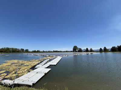
This unique project is one of Oregon’s first floating solar installations, featuring 1,776 solar panels on a reservoir in the Medford Irrigation District. By covering about 1.8 acres of water, the project will:
- Generate local, renewable energy for the community
- Improve water quality by shading the reservoir and reducing algae growth
- Reduce water loss from evaporation
60 residential subscriptions will be available for households in the Medford area, giving local families the chance to save on energy costs while supporting innovation in clean energy.
The project is expected to begin operation in Summer 2026.
Be part of this exciting milestone for Oregon — reserve your spot today and power your home with clean, local solar energy.
Medford Irrigation District Community Solar Subscription Example:
- Subscription Size: 5 kW
- Expected 1st year subscription generation: 7,545 kWh
- Expected Bill Credit: $782
- Expected Subscription Fee: $717
Expected First-year Net Savings: $65
Who’s Eligible?
To be eligible for the MID Community Solar Project Subscription, you must:
- Live within the Medford Irrigation District territory.
- Be a customer of Pacific Power.
Low-Income Subscribers
10% of the project’s energy is reserved for low-income households = low-income households can subscribe!
If you qualify, you’ll get special benefits and protections as a subscriber. You’ll have:
- no upfront costs
- no termination fees
- discounts on your subscription, and
- guaranteed savings on your energy bill.
Community solar is a large solar system that members of the community can join to share the benefits of the solar energy that’s generated. This is great for people who don’t want to install their own rooftop solar or who rent or live in apartments or condominiums. The energy generated by the Medford Irrigation District goes to the utility energy grid, and the value of that energy is shared by all subscribers in the form of credits on your utility bill. So you can feel good about supporting clean, renewable energy without paying the upfront costs of your own rooftop solar panels.
City of Roseburg Government — Wondering where to get the facts about City projects, plans, decisions, events and upcoming meetings?
𝗙𝗲𝗮𝘁𝘂𝗿𝗲𝗱 𝗙𝗼𝗼𝗱 𝗣𝗮𝗻𝘁𝗿𝘆: 𝗦𝗮𝗹𝘃𝗮𝘁𝗶𝗼𝗻 𝗔𝗿𝗺𝘆 𝗣𝗮𝗻𝘁𝗿𝘆 


Southern Oregon PBS Still on The Air Despite Federal Funding Loss

Rogue Valley Humane Society
Our Community Food Bank exists to help folks who need an extra helping hand during a difficult month to feed their pets. Our program has a limited budget and so we rely on generous members of our community to donate some of these goods to continue to help assist our community. In 2023 we fed an average of 700 pets a month!
This equates to approximately 70 – 40lb bags of food each month! Many pets have benefited from the community’s generosity, and we can’t thank you enough for your kindness.
CSO Case 24-4928 PROSPECT, Ore. – Jackson County Sheriff’s Office (JCSO) detectives and Search and Rescue (SAR) personnel continue to search for a woman missing out of Prospect, Ore. since September 2024.
Deenah Padgett, 69, was reported missing on Sunday, September 8, 2024. She was last seen camping in the Prospect area on September 4, 2024.
She is described as a white woman with brownish-red, partially gray hair, standing 4’8” tall and weighing 90-100 lbs. JCSO detectives and SAR personnel have searched the area extensively and are looking for the public’s help. If you see Deenah or know her whereabouts, immediately call ECSO Dispatch at (541) 776-7206 and reference case 24-4928.
If you have any information that might help the investigation, call Detective Friend at (541) 864-8774.
The Jackson County Sheriff’s Office (JCSO) is asking for help identifying the owner a motorhome. It could be associated with a missing person from the Prospect area. JCSO says 68-year-old Deenah Padgett has been missing since August 30 from Prospect, described as a white woman, 4’ 8” tall, weighing approximately 95 pounds with brownish red/greying hair. JCSO issued an advisory this weekend asking anyone with information about the owner of the pictured motor home or Padgett’s whereabouts to call Emergency Communications of Southern Oregon (ECSO) dispatch non-emergency phone number at 541-776-7206.
David Grubbs’ Murder Investigation Remains Active
The Ashland Police Department’s investigation into the murder of David Grubbs on November 19, 2011 remains open and active. Recently two new detectives have been assigned to look into new leads that have come in.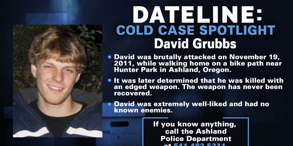 This case remains important to David’s family, the community, and the Ashland Police Department. As detectives continue to pursue these new leads, anyone with additional information is encouraged to reach out to the Ashland Police Department at 541-488-2211. The reward for information leading to an arrest on this case remains at over $21,000.
Taking Another Look at What Happened to Fauna Frey
Fauna was grieving the recent death of her brother, Dallas, when she set off from Eugene in June of 2020 heading to Grants Pass on what her family believes was both a healing trip and a mission to deliver gifts, silver coins inherited from Dallas, to a few friends. But somewhere between motel check-ins and checkouts, something went terribly wrong. Her Jeep was found months later. She was never seen again. http://bit.ly/4l63Dle

We will start resharing podcasts and articles. For starters here is a story from Danielle Denham that appeared in the June 29, 2025 edition of That Oregon Life. Ms Denham worked closely with us to insure that the facts she presented were accurate. Check out the nine episodes of the podcast Nowhere to be Found, a comprehensive, in-depth, sensitive treatment of the details surrounding Fauna’s disappearance. Hear from Fauna’s father, John, and her friends. Posted in spring of 2022, Amanda Popineau shares Fauna’s journey and the mystery that surrounds it. Go to Nowhere to be Found Season Two: Episode One “Under A Half-Moon.”
https://podcasts.apple.com/kg/podcast/s2e1-under-a-halfmoon/id1532686678?i=1000512098162
We want to remind people that Fauna’s father is offering a huge reward for information that brings Fauna home. Please if you have any information no matter how big or small let us know by calling the anonymous tip line or emailing. Tipline- 541-359-5638 Email – Helpfindfaunafrey@gmail.com FOLLOW on FACEBOOK GROUP: https://www.facebook.com/groups/341658526970132
Fauna Frey Vanished Without A Trace In Josephine County
 It’s been more than five years since the disappearance of a Lane County Woman, who was last seen in Grants Pass. Back in June of 2020, Fauna Frey disappeared. Police said the 45-year-old left her home in Dexter to drive to Grants Pass to visit her brother’s friend after her brother had recently passed away. The last place she was seen was at the Big 5 in Grants Pass. Investigators said her car was found in the Galice area months later. The circumstances of Fauna’s disappearance remain unclear and her case is currently classified as missing. Her case remains unsolved. Fauna’s disappearance has been featured on multiple investigative podcasts, including Nowhere to be Found, Here One Minute, Gone the Next, and Detective Perspective, each trying to fill the silence left by law enforcement. New listeners continue to discover her story, hoping a fresh set of eyes or a single loose memory might be the key to finding Fauna.
Have Information on Fauna Frey? Please Speak Up!
If you know anything, no matter how small, please contact:
- Josephine County Sheriff’s Office
- Tip line: (541) 359-5638
- Email: FindFaunaFrey@gmail.com
Currrently there is a $50,000 CASH REWARD for information leading to the location of Fauna Frey. LARGE CASH REWARDS are being offered for any other relevant information, such as any objects that could be identified as Fauna’s, i.e. her wallet, keys, or Indian/Buffalo .999 silver bullion coins. Find Fauna Frey Facebook Group: https://www.facebook.com/groups/341658526970132
You can find food in your community at this link
Our network of food banks and pantries provides free food and groceries across Oregon. No proof of income or documentation required.
https://www.oregonfoodbank.org/
If you can’t make it to a food location, someone else can pick up food for you.You will just need to print and fill out the Authorized Representative form at https://lnkd.in/dsskUpkQ, and have them take it with them to the food sites. You can find step-by-step instructions at https://lnkd.in/dVBRxn-A.
Worried about recent changes or losing assistance?
Here are resources that can help: 211Info: Dial 2-1-1 or visit the211Info food webpagefor information and referrals to more than 1,500 food resources across Oregon. Oregon Food Bank: Use the Oregon Food Bank’s Food Finder Map to find over 100 food pantries, free food markets or hot meal programs near you. Aging and Disability Resource Connection of Oregon (ADRC): Call 855-673-2372 or visit theADRC food webpage to find local meal programs and food boxes in your area.

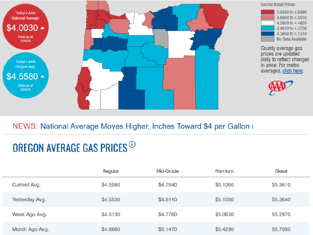
7/20/2026 — Gas Prices in Oregon Today
A fire that was sparked by someone shooting at an exploding target on their property west of Redmond led to Level 3 “Go Now” evacuations Sunday afternoon. It was the second time in three days Redmond firefighters had to scramble to save homes.
The Oak Fire started around 2:30 p.m. in the area if Hwy 126 and Oak Lane. Multiple agencies responded, including air support. Redmond Fire and Rescue said callers reported trees on fire and that structures were threatened. Forward progress was reported stopped around 6:30 p.m.
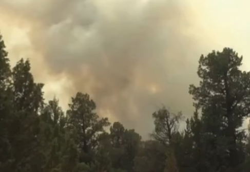
The fire was raised to a 3-alarm as multiple agencies responded, including support from helicopters. No structures were lost, Redmond Fire said.
“Fire investigators determined that the property owner was shooting at an exploding target,” Redmond Fire said in a press release. “The exploding target was impacted by the round from a .223 rifle round, when the target exploded the fire quickly began.”
Redmond Fire noted that shooting on private property may not be restricted, but those responsible can be held liable for fires that start because of it. The property owner in this case was cited for reckless endangering and reckless burning.
Level 2 and 3 evacuations were ordered, but have since been lifted.
On Friday, a fire in Redmond’s Dry Canyon prompted evacuations. Redmond Fire said no homes burned, but an outbuilding and ADU were damaged.
Emergency Conflagration Act invoked for Akawa Butte and Brewer fires in Deschutes and Jefferson counties
Oregon State Fire Marshal
SALEM, Ore. – On Saturday morning, the Emergency Conflagration Act was invoked for the Akawa Butte and Brewer fires in Deschutes and Jefferson counties. The Oregon State Fire Marshal is assigning its Red Incident Management Team and several task forces to the fires to work alongside its wildland partners to protect nearby communities and critical infrastructure.
Hot, dry weather and strong, shifting winds created difficult firefighting conditions across Central Oregon Friday. The fires have grown significantly, threatening nearby communities. The Deschutes and Jefferson County sheriff’s offices have levels 1, 2, and 3 evacuation notices in place. Those looking for evacuation information should follow their local sheriff’s office.
Conditions will continue to be hot and dry on Saturday. The wind will be light in the morning but is expected to increase in the afternoon. Fire managers expect challenging, wind-driven fire activity later in the day.
“The conditions we’re seeing across Oregon have challenged firefighters for the past week and the current forecast isn’t providing much relief,” State Fire Marshal Mariana Ruiz-Temple said. “I’m urging every Oregonian to be wildfire aware and to sign up for their county’s emergency alerts. Know the evacuation levels and follow them if they are issued.”
The Oregon State Fire Marshal Red Incident Management Team will be in unified command with the Oregon Department of Forestry’s Team 2.
This is the fifth time the Emergency Conflagration Act has been invoked in 2026. The Oregon State Fire Marshal is posting updates on incidents it has resources assigned to on osfminfo.org. Oregonians can sign up for emergency alerts at oralert.gov.
Oregon adds California & Washington fire service resources as wildfire activity strains statewide capacity
With Oregon’s fire protection resources heavily committed to wildfires across the state, the Oregon State Fire Marshal is bringing in five task forces from California and two task forces from Washington to focus on protecting communities and critical infrastructure as the state faces extreme fire conditions.
Earlier this week thunderstorms moved through the region, dropping thousands of lightning strikes and sparking numerous wildfires. These additional firefighters and equipment will support fires the state fire marshal has resources assigned to and will be available for any emerging incidents.
The resources were mobilized through the Emergency Management Assistance Compact in coordination with the Oregon Department of Emergency Management.
“The Oregon fire service is doing extraordinary work across the state, but the number of active incidents is placing a significant demand on the system,” State Fire Marshal Mariana Ruiz‑Temple said. “Bringing in resources from other states is a common practice that supports the entire wildfire response system.”
The California resources will be assigned according to incident priorities and may support community defense, structure triage, protection of critical infrastructure, and other missions aligned with their qualifications. The task forces from Washington are working alongside Oregon crews in Wheeler County on the Rowe Creek Complex.
The Oregon Department of Forestry, tribal, and federal wildland agencies will continue managing wildland suppression operations within their respective jurisdictions. The Oregon State Fire Marshal resources, including those arriving from California and Washington, are focused on reinforcing local fire service capacity and community protection efforts.
“Oregon, California, and Washington have a long history of helping one another during emergencies,” Ruiz-Temple said. “Oregon firefighters supported California communities in 2025 during the Los Angeles wildfires, and we are grateful that our neighboring states are able to answer Oregon’s request for help.”
The Oregon State Fire Marshal has resources assigned to four conflagrations and one Immediate Response incident. For more information about the agency’s mobilizations and updates, visit https://osfminfo.org.
Oregon Department of Foresty deploys additional Complex Incident Management Team to manage more central Oregon wildfires
Oregon Dept. of Forestry
PRINEVILLE, Ore. – The Oregon Department of Forestry (ODF) is deploying its Complex Incident Management Team 3 (CIMT) to manage the Brewer and Box Springs wildfires in the Prineville and Sisters area. This is the third and last ODF-staffed team the department has available. The deployment is necessary due to the unusual early season “resistance to control” nature of these lightening caused fires in central Oregon.
The Brewer fire started Wednesday and grew to estimated 14,000 acres today; on Thursday it was at 3,000 acres. It is currently managed by ODF CIMT 2, but Team 2 also has the Pilot and Akawa fires. So, ODF CIMT 3 will take over the Brewer fire and the Box Springs fire. Box Springs was only 40 acres this morning but has grown rapidly. It is burning in timber and grass. ODF firefighters describe some of the terrain as steep nasty canyons and draws which make it difficult to battle.
ODF fire managers stress patience and safety as resources are stretched thin and firefighters have been putting in long days and nights. All local resources are committed but additional air and ground firefighting resources have been ordered through partnerships with other states. However, it may take a while to fulfill all the requests since the Northwest region has multiple large fires asking for additional resources.
The fires managed by both ODF CIMTs in central Oregon have evacuation orders that are issued by county sheriff’s offices, to see the latest and to set up alerts from the counties go to: https://centraloregonfire.org
Fire Restrictions: BLM Urges Public Vigilance as AI Cameras Enhance Wildfire Detection
Statewide fire restrictions remain in effect for all Bureau of Land Management public lands throughout Oregon and Washington, and many local regions have additional restrictions in place. BLM leaders encourage all visitors to be aware of all active restrictions and closures as warmer weather continues across the Pacific Northwest.
As the region faces heightened fire danger, emergency managers are leveraging advanced ALERTWest AI-powered camera networks to detect new smoke ignitions in real time. These public-facing cameras scan regional landscapes using artificial intelligence to spot visual anomalies, allowing both emergency crews and community members to monitor active fire behavior and smoke plumes in real time.
“Technology is helping us detect fires sooner than ever before, but preventing human-caused fires still depends on the public,” said Josh O’Connor, Northwest Geographic Area Fire Chief for the U.S. Wildland Fire Service. “Following local restrictions remains one of the most effective ways people can protect their communities and public lands.”
Restrictions vary based on local fire danger, weather conditions and fuel moisture. Visitors must continue to research their destinations in advance, as local restrictions govern when visitors can use power tools, what kinds of stoves or campfires are allowed, and what type of safety equipment to have on hand. The following items remain strictly prohibited on all BLM lands in Oregon and Washington:
- Fireworks and sky lanterns
- Exploding or metallic targets
- Tracer or incendiary devices
- Steel component ammunition (core or jacket)
“Our communities and public lands are much safer when we work together,” said Kim Prill, BLM Oregon/Washington Acting State Director. “Please continue to monitor local restrictions and take every precaution to prevent human-caused wildfires as we approach the peak of fire season in the Pacific Northwest.”
Officials warn that individuals responsible for starting wildfires face up to $100,000 in fines, 12 months in prison, and liability for all firefighting suppression costs.
For more information on seasonal fire restrictions and fire closures, please see www.blm.gov/orwafire.
Almost 87 percent of Oregon is currently experiencing at least a Moderate Drought, despite recent rainfall.
According to NOAA, the Pacific Northwest has recorded its highest temperatures in the past five years since record-keeping began 130 years ago. The insufficient snowpack accumulated during winter is expected to negatively impact river levels as the region transitions from summer to fall.
Governor Kotek has issued drought declarations for nineteen counties in Oregon, while requests from Curry and Union counties are still under consideration.
Controversial Oregon animal rights petition might not have enough valid signatures to make ballot
A controversial initiative petition to ban killing or harming animals in Oregon with almost no exceptions may not qualify for the November ballot.

The petition failed the first round of the signature verification process, a spokesperson for the secretary of state’s office told the Capital Chronicle. However, it could still reach the ballot if it passes a second, larger review.
Framed as an anti-animal cruelty petition, Initiative Petition 28 is an effort led by Portland-based vegan advocates to expand the state’s animal cruelty laws to include hunting, fishing, breeding, farming and research. Essentially, it would ban killing or injuring animals in all cases except for self-defense or veterinary care.
It’s highly unpopular among Oregonians across the political spectrum, but petitioners submitted 142,784 signatures to the Oregon Secretary of State’s office earlier this month — more than the 117,173 required to qualify for the ballot.
The Oregon Secretary of State’s Election Division must verify those signatures using statistical analysis across two random pools. The first round uses a smaller sample of 1,000 signatures, and examines if the signatures match each person’s voter registration records.
“In the first sample, 804 of the sampled 1,000 signatures were found to be valid,” said Connor Radnovich, a spokesperson for the Oregon Secretary of State’s Office. “Once the standard statistical formula was applied, it was determined that the petition did not have enough valid signatures to qualify for the ballot.”
The signature verification team has moved on to a second, larger sample. The secretary of state has until Aug. 2 to complete the verification process.
Before submitting signatures, the lead petitioners in a newsletter said they had already conducted their own signature verification process, removing 8,000 signatures from their original collection that were duplicates or from people who weren’t registered to vote.
If the petition doesn’t make the ballot, there would be no statewide citizen initiative on the general election ballot, Radnovich said. (SOURCE)
A black bear yearling that wandered into a southwest Eugene neighborhood was euthanized after wildlife officials determined it was severely distressed and possibly suffering from rabies.

Residents in the Fox Hollow area reported the bear showed up earlier in the morning and wouldn’t leave. They said the bear was covered in ticks and appeared to be in distress.
Residents called the Oregon Department of Fish and Wildlife, but it took several hours for crews to arrive. Wildlife officials were able to wrangle the bear into a portable kennel and began transporting it to their vet.
During transport, the bear collapsed in the kennel and was drooling heavily. Crews decided to euthanize the bear due to its condition. ODFW officials believe the bear may have been suffering from rabies and will conduct a necropsy to confirm.
ODFW officials are emphasizing that people should not attempt to help distressed wildlife themselves and should always call experts, especially when an animal is displaying unusual behavior.
L. L. Stub Stewart and Rooster Rock State Parks will host OMSI Star Parties this summer

— L.L. Stub Stewart and Rooster Rock State Parks will celebrate the night sky with free stargazing parties in July, August and September.
The parks are partnering with OMSI and Rose City Astronomers to host an OMSI Star Party 2026, which includes a presentation at dusk and stargazing from 9 to 11 p.m. Telescopes will be provided by volunteers, and visitors are welcome to bring their own. Depending on the weather, stargazers will search out stars, the moon, and planets.
“We love helping people experience the park in a different way. After dark, everything feels calmer, quieter, and a little more magical,” shared Park Ranger Jeremy Williams at L. L. Stub Stewart State Park.
These events are free. Parking in the day-use areas requires a $10 parking permit per vehicle or you can use an annual parking pass if you have one.
Visitors are encouraged to bring their own chairs, blankets, warm clothing, snacks and water. Bug repellent is always a good idea. Please use red flashlights to avoid interfering with the dark sky viewing. You can also cover your flashlight or smartphone with red electrical tape.
Star maps will be provided along with recommended astronomy apps that visitors can load on their phones if interested.
Visitors should arrive early to familiarize themselves with the area and park only in designated spaces. Overnight camping is not permitted in day-use areas, though campground reservations are available at stateparks.oregon.gov.
On the scheduled day for OMSI Star Parties, visitors should visit the OMSI website for possible weather-related cancellations. The long-range forecast looks promising for excellent viewing.
“Whether you come to Rooster Rock to count Perseids or simply to spend a peaceful evening under the stars, the meteor shower is a wonderful excuse to slow down, look up, and experience the Gorge in a whole new light”, said Park Ranger Elika Paki at Rooster Rock. “And if you lose track of how many shooting stars you’ve seen, don’t worry, that just means you’re doing it right.”
All events begin at dusk. We recommend arriving early to accommodate parking. Parks will close at 11:45 p.m.
Perseid Meteor Shower Watch | Wednesday, August 12
- L. L. Stub Stewart State Park
- Rooster Rock State Park
Equinox Celebration | Saturday, September 12
- L. L. Stub Stewart State Park
You can find additional details about the event, parking logistics, whether pets are allowed, and how to request accessibility accommodations on the L.L. Stub Stewart State Park and Rooster Rock State Park event pages, and the OMSI event page.
Oregon State Parks often hosts stargazing events across the state. More opportunities can be found on Oregon State Parks’ event page.
Regional earthquake experts say more coordination, investment needed to prepare for ‘Big One’
Plans to ensure critical transportation, water and fuels corridors exist after a devastating regionwide earthquake need more urgent attention, experts said.

If the “Big One” — the anticipated massive Cascadia Subduction Zone earthquake — hit today, Oregonians west of the Cascades would be luckiest to find themselves at the recently-retrofitted state Capitol in Salem or on the roof of the new terminal at the Portland International Airport.
The comment from Tom Wharton, an engineer at the Port of Portland, drew laughs from an audience Thursday at the 13th annual National Conference on Earthquake Engineering in Portland, but it wasn’t entirely a joke. Jonna Papaefthimiou, state resilience officer in Gov. Tina Kotek’s office, said few of the 4,000 buildings the state owns would survive. Just five would likely remain standing and be immediately usable in the weeks and months after, she said.
The Port of Portland and the governor’s office are among the members of the region-wide multi-agency Cascadia Lifelines Program housed at Oregon State University, operating as a think tank for stakeholders who meet twice annually to discuss preparation for what seismologists project will be a 7.4 or greater magnitude earthquake in the Northwest in the next 50 years.
The Cascadia Subduction Zone quake occurs off the coasts of Oregon, Washington and California every 500 years and was last recorded in 1700. It could cause Northwest coastlines to lower and retreat, spur widespread flooding and landslides and displace millions of people.
The experts discussed progress: Renovations at the Portland airport and state Capitol that made the buildings more likely to withstand earthquakes, a plan to ensure Washington County residents have access to water sourced from beyond Portland’s system and Kotek’s 2025 executive order mandating large state-owned buildings be retrofitted during the next 35 years and new ones be built to a worst-case-scenario earthquake code.
But the experts also discussed policies that they say should be enacted urgently.
If coastal U.S. Route 101 isn’t retrofitted before the Big One hits and shuts down for any extended period following the quake, “then you’ve lost those coastal communities, and you’re not going to get those back,” said Mike Olsen, an Oregon State University civil engineering professor and the director of the Cascadia Lifelines Program.
The highway is also already under frequent threats of coastal landslides and flooding.
“We don’t need to wait for the earthquake to cause a lot of damage to it. It’s already under a lot of pressure,” he said.
Race to retrofit — In coastal areas that will be most heavily impacted, and that are heavily reliant on grid power from the Bonneville Power Administration, policies that promote community microgrids and battery storage will be key to post-quake recovery, said Leon Kempner, a BPA engineer.
BPA controls most of the Northwest electricity distribution grid. In some coastal areas, such as Lincoln City, it is the source of nearly all power.
Kempner said the agency is racing to retrofit the grid to withstand earthquakes, but it didn’t start implementing seismic code into projects until the 1980s, and it lacks resources to move as quickly as needed.
He also suggested that the Oregon and Washington state legislatures should require BPA and all regional utilities to regularly report to state officials on what they are doing to prepare for the Big One to increase awareness, transparency about planning gaps and potential for collaboration.
Wharton, who explained that much of the state would rely on the airport and the port’s four Willamette and Columbia river terminals to receive recovery aid, said the Port of Portland needs nearly $500 million to upgrade a runway that can survive the quake and handle large Federal Emergency Management Agency aircraft, and other aircraft, landing for support or evacuation.
Port officials will meet with Kotek’s office in the next few weeks to discuss some potential budget requests, he and Papaefthimiou said. Some funding could also come from requesting an advance on annual maintenance dollars from the Federal Aviation Administration or grants from FEMA, “as long as FEMA still exists,” Wharton said.
A recent study by the National Institute of Building Sciences found that the, for now, roughly $450 million investment would have a net $7 billion savings benefit for the state as it tries to recover and rebuild after the quake, he said. But none of that matters if roads and bridges are unusable or nonexistent.
Critical corridors — The Oregon Department of Transportation has identified $40 million worth of bridge deficiencies that, if left unaddressed, leave them vulnerable to the quake, said Yumei Wang, a civil engineering and infrastructure resilience and risk expert from Portland State University.
Olsen and other experts also called for more investment in preparing a disaster response workforce for the state and the region, which would require months of emergency attention and years of rebuilding. Everyone agreed that municipal governments, state leaders, and all regional infrastructure stakeholders need to be more regularly talking and planning together, now.
Mike Britch, an engineering and construction manager at Tualatin Valley Water District, is overseeing a $1.6 billion water infrastructure project to shift the half of Tualatin that relies on water from the Portland Water Bureau to water sourced from the Joint Water Commission that also supplies water to the cities of Hillsboro, Forest Grove and Beaverton.
Part of the project involved building a 2,000 foot “micro tunnel” under the Tualatin River to transport drinking water. Above it, the Roy Rogers Road bridge over the river would not survive the Big One, Britch said, leaving people south of the bridge stranded and unable to get to any area hospitals.
“If I could create a policy and make people do things, I would say I want the state to identify some of these really critical corridors,” he said. “We need some sort of policy to address that.” (SOURCE)
Oregon farmers reliant on irrigation have faced a challenging start to the season, with little improvement in conditions as the months progress.
Many are experiencing reduced water availability, with certain fields in Central Oregon facing unprecedented water restrictions. In Southern Oregon, growers are being incentivized to leave their fields unplanted, and there is a growing concern that water regulators may need to impose further restrictions before the end of the growing season.
Stream flows in rivers throughout most of Oregon’s basins are significantly below average for this time of year. The state’s snowpack, which typically serves as a natural reservoir, was disappointingly low this past winter, coinciding with some of the warmest winter months on record. In various areas of the Cascades, the limited snow that did accumulate is melting weeks earlier than expected.
Public invited to comment on plan to possibly triple logging in eastern Oregon national forests
The U.S. Forest Service’s proposed revisions to the Blue Mountain Forest Plan would allow more logging and taking older trees in the name of wildfire prevention
Officials at the U.S. Forest Service are proposing new management plans for eastern Oregon’s Blue Mountains that include potentially tripling the amount of logging across 5.5 million acres in the next decade.

The Forest Service published a draft of proposed changes to the 35-year-old Blue Mountain Forest Plan last week. It would allow more logging, mining and grazing across four national forests spread across eastern Oregon, as well as parts of southeast Washington: the Malheur, Ochoco, Wallowa-Whitman and Umatilla National Forests.
The public has until Sept. 30 to submit comments on the 350-page draft proposal.Submit comments on the revised Blue Mountain Forest Plan here.
The draft plan describes increases in logging and animal grazing as important to local economies and to preventing wildfire.
It predicts everything from habitat conservation to forest carbon storage would improve over the long term if more logging is allowed because strategically logging and grazing parts of the forest would prevent wildfire, which officials characterize as the biggest threat to habitat and forest loss.
Environmental advocates disagree with the framing.
The Blue Mountains encompass Oregon’s largest protected wilderness areas. Conservation groups have expressed concern and outrage over the draft management plan, which they say could exacerbate area drought and water quality issues, wildfire risks and impact habitat for elk, wolverine, wolves, moose, owls and salmon.
“This plan seeks to open up and pillage one of the wildest places left in the U.S.,” Lauren Anderson, a climate forests manager at the nonprofit Oregon Wild, said in a statement. “The Trump administration is already taking a hatchet to protections for water, wildlife and the public’s voice. This plan is that philosophy in action, putting at risk the very values that make the Blue Mountains special.”
Bev Law, a forest scientist and professor emerita at Oregon State University who has studied extensively the potential forest carbon storage in Oregon forests, found that protected wilderness areas in the Blue Mountains contain the second highest proportion of above-ground carbon stocks in all of Oregon’s protected wilderness areas.
Nick Smith, a spokesperson for the American Forest Resource Council, a trade association representing the timber industry, said in a statement that the group is still reviewing the proposed updates but that change is overdue.
“These national forests face some of the highest wildfire, insect and disease risks in the West. At the same time, the region is steadily losing the sawmills, logging contractors and the skilled workforce needed to carry out active forest management and provide markets for the material that needs to come out of the woods,” he said.
The draft Blue Mountain Management Plan proposal also includes rescinding a 32-year-old rule called the Eastside Screens that prohibits logging trees that are 21 inches in diameter or larger on six eastern Oregon and Washington national forests. Forest Service officials attempted to rescind the rule during the first Trump administration, but conservation groups sued and it was blocked by a federal judge.
Forest Service officials have argued that some younger trees that grow fast should be able to be removed even if they are more than 21 inches in diameter, because they are crowding out other tree species that take longer to grow but are important to the forest ecosystems.
The proposal also assumes Congress will soon rescind the 25-year-old Roadless Rule, which prohibits road construction, logging and mining on roughly 60 million acres of public land, including about 2 million acres of forests in Oregon. That alone would increase the amount of land classified as open for logging in the Blue Mountains by 17%, according to the draft.
Most of the increased logging would take place in the Malheur National Forest, followed by the Wallowa-Whitman and then Umatilla national forests. (SOURCE)
The Oregon Division of Financial Regulation has issued a warning regarding a newly identified fraud ring that enrolls individuals in life insurance policies without their awareness or consent.
This fraudulent activity primarily targets older adults and has been reported across several states, including Oregon. The scheme involves licensed insurance agents who initiate contact with victims through multiple telemarketing calls, during which personal information is solicited. This information is subsequently passed on to the participating insurance agents, who then reach out to the victims to gather any additional details necessary to finalize an application for a life insurance policy.
These applications are submitted without the victims’ knowledge, resulting in the issuance of one or more policies for which the agents receive commissions, despite the fact that the premiums have not yet been paid. The fraud typically comes to light when the insurance company seeks the initial premium payment.
The Division of Financial Regulation’s consumer advocates are available to assist with inquiries or to facilitate the filing of complaints. They can be contacted at 1-888-877-4894 or via email at DFR.InsuranceHelp@dcbs.oregon.gov for insurance-related assistance, and dfr.financialserviceshelp@dcbs.oregon.gov for help with financial services.
Check out Oregon State Parks with your library card
Borrow an Oregon State Parks parking permit for free at 82 libraries statewide.

– Oregon Parks and Recreation Department (ORPD) and the State Library of Oregon are partnering to offer free state parks parking permits to Oregon public libraries. There are currently 200 parking permits available at 82 libraries across the state.
“Oregon’s state parks are for everyone,” said OPRD deputy director JR Collier. “As we assess ways to manage our budget responsibly, we also want to uplift equitable access to our parks.”
Each participating library received up to four parking permits. These are the physical hang tags you check out from the library and put in your car. The permit covers parking in all Oregon State Parks day-use areas for one vehicle. Go to the Oregon State Parks website to find participating libraries. All you need to participate is your library card.
“Libraries help make life more affordable for Oregonians. This program leverages the existing borrowing system to help connects folks of all income levels with the beauty and splendor of Oregon’s State Parks,” said Wendy Cornelisen, State Librarian.
Both OPRD and the State Library contributed 100 parking permits to the program to distribute to libraries. The agencies determined how many passes each library would receive based on interest from the library, its proximity to a park charging a day use fee, and the size of the population it serves. The State Library purchased permits with Library Services and Technology Act funds from the federal Institute of Museum and Library Services.
OPRD first distributed parking permits to 28 libraries as part of a year-long pilot program starting in August 2024. Those passes were checked out more than 2,100 times. At the pilot’s conclusion, OPRD evaluated how to best move the program forward in the context of its changing fees. In 2027, OPRD and the State Library will continue to explore options for an expanded long-term program that will serve even more libraries and people in Oregon. Learn more about the OPRD Library Pass Program.
Oregon Department of Veterans’ Affairs
No veteran should be without a place to call home, and the Oregon Department of Veterans’ Affairs is committed to ending veteran homelessness in our state. The new ODVA Houseless Veterans Program collaborates with federal, state, county, and Tribal agencies, veteran services offices, and community homeless service providers to meet the urgent and unique needs of Oregon’s diverse veteran communities challenged with housing stability. In addition to advocating for Oregon veterans experiencing or at risk for houselessness, the program provides direct service to veterans and their families seeking federal and state veterans’ benefits, including access to local VA health care, documentation of service, as well as other available state benefits, and local homeless services organizations and low-income assistance programs. If you or a veteran you know is dealing with homelessness, contact the ODVA Houseless Veterans Coordinator today at houselessvets@odva.oregon.gov or visit https://ow.ly/V4EH50VnL93 to learn more.
Staying Informed During a Communications Outage: Best Practices for the Public
Disasters can damage critical infrastructure, leading to temporary outages in cell service, internet, and power. When communication systems go down, it’s vital to be prepared with alternate ways to get emergency information and stay connected. Here’s how you can prepare and respond:
Have a Battery-Powered or Hand-Crank Emergency Weather Radio
- Why it matters: Emergency radios can receive Emergency Alert System (EAS) broadcasts via AM/FM or NOAA Weather Radio frequencies—even when cell towers and the internet are down.
- Note: Emergency radios do not receive Wireless Emergency Alerts (WEA) like cell phones do. Tip: Pre-tune your radio to your local emergency broadcast station (e.g., OPB in Oregon or NOAA frequencies).
Turn On WEA Alerts on Your Phone
- Make sure Wireless Emergency Alerts (WEA) are enabled in your phone’s settings. These alerts include evacuation orders, severe weather warnings, and other urgent notifications.
- WEA messages are sent through cell towers—if cell service is out, WEA alerts will not be delivered. This is why having backup methods like a radio is essential.
Charge Everything in Advance and Have Backup Power
- Charge phones, power banks, laptops, and rechargeable flashlights before fire weather conditions worsen.
- Consider solar-powered chargers or car chargers as backups.
- If you are sheltering in place, a generator (solar or gas powered) is helpful.
Know Your Evacuation Routes in Advance
- Save printed or downloaded evacuation maps in case you can’t access GPS or navigation apps.
- Most mapping services (like Google Maps or Apple Maps) offer the ability to “Make maps available offline.” Download your area in advance so you can navigate even if cell towers or internet access are down.
- When in doubt, call 511 or visit the TripCheck.com website if you have cell service.
- Don’t wait for a notification—if you feel unsafe, evacuate early.
Print or Write Down Critical Contacts and Info
- Phone numbers of family, neighbors, and local emergency contacts.
- Address of evacuation shelters, veterinary services (for pets/livestock), and medical facilities.
- Your own emergency plan, including meeting locations.
- Have copies of vital documents in your go-bag and take video of your property (inside and out) for insurance claims later.
If Calling 9-1-1 Over Wi-Fi or Satellite, Check Your Location Settings
If you call 9-1-1 using Wi-Fi calling or a satellite-connected phone (like an iPhone or Android), your location might not be automatically visible to dispatch. Instead, it may rely on the emergency address saved in your phone’s settings.
- Update this emergency address when you travel or relocate—especially in evacuation zones or rural areas.
- Most importantly, always tell the dispatcher exactly where you are—include your address, landmarks, road names, or mile markers to help first responders reach you quickly.
Sign Up for Alerts Before There’s an Outage
- Register for OR-Alert and your county’s local alert system.
- Follow your local emergency management officials’ and bookmark resources like: wildfire.oregon.gov.
Prepare for Alert Delays or Gaps
- Know the three levels of evacuation:
- Level 1 – Be Ready
- Level 2 – Be Set
- Level 3 – GO NOW
- If you hear a siren, see a neighbor evacuating, or witness fire behavior increasing—take action even if you haven’t received an alert.
Be Your Own Info Network
- Check on neighbors, especially seniors or those with disabilities.
- Post printed signs with updates for those passing by.
In rural areas, community bulletin boards or fire stations may serve as local information points. Support and Restoration in Progress To help maintain emergency communications during this incident, OEM deployed eight Starlink terminals under the guidance of ESF 2 and the Statewide Interoperability Coordinator (SWIC). A Communications Technician (Jeff Perkins) was also deployed to assess connectivity needs on the ground. These Starlink terminals have been providing service to the Lake County Emergency Operations Center (EOC), Oregon State Police (OSP), Warner Creek Correctional Facility, and will soon support the town of Lakeview, the Bureau of Land Management (BLM), and the Lakeview Ranger Station. OEM’s Regional Coordinator (Stacey) is also on-site supporting the Lake County EOC. Coordination has been strong across local, state, and private sector partners. *** Update: As of 7/10/25 at 1:47 PM, fiber service has been restored.
Reconnect When Service Returns
- Once communications are restored, check official websites:
- Oregon.gov/oem
- Your county emergency management page
- TripCheck.com for road conditions
- Share verified info—not rumors—on social media or community pages.
Prepare for Delays in Restoration
- Communication may come back in phases. Damage to fiber lines or cell towers can take time to repair.
- Continue using backup methods and stay alert for updates via radio or in-person notices.
Final Tip:
In an emergency, CALL 9-1-1 to report life-threatening danger, not for general information. Use local non-emergency numbers or go to physical information points if needed. You can find more tips for preparing in OEM’s Be2Weeks Ready toolkit.

Oregon’s Missing Persons
Many times you’ll see postings without case numbers or police contact. There is rarely a nefarious reason why (the nefarious ones are pretty obvious). Usually the loved one tried to call to report their missing person and they are either refused or told to wait a day or two by people who are unaware of SB 351 and the laws that they are bound to when answering the phone. Many people don’t bother calling LE if their loved one is homeless or in transition because they believe LE won’t care. The biggest myth is the 24 hour rule.

In Oregon we don’t have those rules and an officer or person answering the phone is not allowed to decide. The law decides. We have Senate Bill 351 and it states that the police CANNOT refuse a request for any reason and they must begin working on it within 12 hours. The person making the report does not have to be related to missing person either. Here is SB 351 written by families of the missing here in Oregon in conjunction with Oregon law enforcement officers. This should be common knowledge, please make it this way. https://olis.oregonlegislature.gov/…/SB351/Introduced
Find the mental health support you need

Click to see all resources https://oregonhealthnews.oregon.gov/find-the-mental-health-support-you-need/?utm_medium=email&utm_source=govdelivery

 Oregon State Police are reminding parents and students of the SafeOregon hotline. It takes reports of potential threats against students and schools. The tips can be made anonymously. They can include safety threats, fights, drugs, weapons on campus, cyberbullying and students considering self-harm or suicide. A technician reviews the reports and assigns them either to police or school administrators. Tips can be made by phone, text, email or on the website https://www.safeoregon.com
  Call us at 5 41-363-7503 Or email us at Info@RogueValleyMagazine.com